

community. Integrating remotely sensed thermal data with other datasets and
modeling will allow questions and applications with ever increasing complexity to
be addressed. The experimental LSD product and the case studies described above
are good examples of the increased complexity in which SST data are being
applied, and this trend is expected to continue.
Aside from addressing more complex questions, integration and modeling have
two distinct advantages for reef managers. First, they allow users and stakeholders
to ‘‘see’’ where and how the data are used, exposing the linkages and assumptions
in the models. Outputs can be adjusted or re-cast with alternate views, data and
management scenarios. Such transparency is a keystone of modern marine reserve
design and is especially important when decisions are made with incomplete or
imperfect data, as is frequently the case (Fernandes et al. 2005; Causey 2010).
Secondly, the education and outreach potential of models to stakeholders and the
wider community cannot be underestimated. Reef managers are often unpopular
with the community because management decisions inevitably do not suit all
interests. Model outputs that bring stakeholders together, or successfully predict
future events (e.g., bleaching, algal blooms, disease), allowing stakeholders to
adapt, gives reef managers credibility and helps them build trust and partnerships
that might otherwise be impossible (Keller and Causey 2005).
At a workshop on satellite monitoring of coral reefs in a changing climate (Nim
and Skirving 2010), a focus group of key scientists and reef managers identified a
number of new integrated remote sensing products that would benefit future science and management. Those products incorporating a significant link to thermal
applications included the ability to: track and predict changes in climate oscillations (e.g., Pacific Decadal Oscillations); identify and monitor thermal fronts for
(a)
(b)
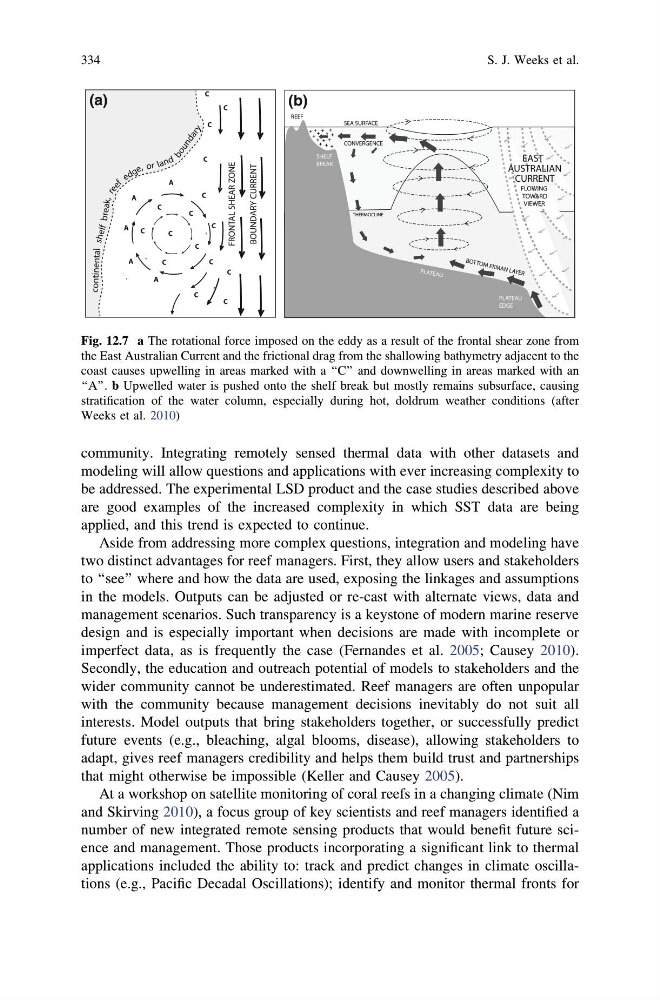
Fig. 12.7 a The rotational force imposed on the eddy as a result of the frontal shear zone from
the East Australian Current and the frictional drag from the shallowing bathymetry adjacent to the
coast causes upwelling in areas marked with a ‘‘C’’ and downwelling in areas marked with an
‘‘A’’. b Upwelled water is pushed onto the shelf break but mostly remains subsurface, causing
stratification of the water column, especially during hot, doldrum weather conditions (after
Weeks et al. 2010)
334
S. J. Weeks et al.
modeling will allow questions and applications with ever increasing complexity to
be addressed. The experimental LSD product and the case studies described above
are good examples of the increased complexity in which SST data are being
applied, and this trend is expected to continue.
Aside from addressing more complex questions, integration and modeling have
two distinct advantages for reef managers. First, they allow users and stakeholders
to ‘‘see’’ where and how the data are used, exposing the linkages and assumptions
in the models. Outputs can be adjusted or re-cast with alternate views, data and
management scenarios. Such transparency is a keystone of modern marine reserve
design and is especially important when decisions are made with incomplete or
imperfect data, as is frequently the case (Fernandes et al. 2005; Causey 2010).
Secondly, the education and outreach potential of models to stakeholders and the
wider community cannot be underestimated. Reef managers are often unpopular
with the community because management decisions inevitably do not suit all
interests. Model outputs that bring stakeholders together, or successfully predict
future events (e.g., bleaching, algal blooms, disease), allowing stakeholders to
adapt, gives reef managers credibility and helps them build trust and partnerships
that might otherwise be impossible (Keller and Causey 2005).
At a workshop on satellite monitoring of coral reefs in a changing climate (Nim
and Skirving 2010), a focus group of key scientists and reef managers identified a
number of new integrated remote sensing products that would benefit future science and management. Those products incorporating a significant link to thermal
applications included the ability to: track and predict changes in climate oscillations (e.g., Pacific Decadal Oscillations); identify and monitor thermal fronts for
(a)
(b)
Fig. 12.7 a The rotational force imposed on the eddy as a result of the frontal shear zone from
the East Australian Current and the frictional drag from the shallowing bathymetry adjacent to the
coast causes upwelling in areas marked with a ‘‘C’’ and downwelling in areas marked with an
‘‘A’’. b Upwelled water is pushed onto the shelf break but mostly remains subsurface, causing
stratification of the water column, especially during hot, doldrum weather conditions (after
Weeks et al. 2010)
334
S. J. Weeks et al.