

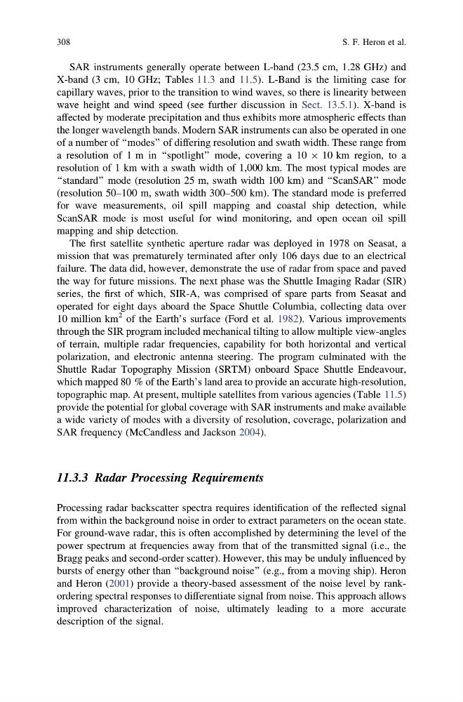
SAR instruments generally operate between L-band (23.5 cm, 1.28 GHz) and
X-band (3 cm, 10 GHz; Tables 11.3 and 11.5). L-Band is the limiting case for
capillary waves, prior to the transition to wind waves, so there is linearity between
wave height and wind speed (see further discussion in Sect. 13.5.1). X-band is
affected by moderate precipitation and thus exhibits more atmospheric effects than
the longer wavelength bands. Modern SAR instruments can also be operated in one
of a number of ‘‘modes’’ of differing resolution and swath width. These range from
a resolution of 1 m in ‘‘spotlight’’ mode, covering a 10 9 10 km region, to a
resolution of 1 km with a swath width of 1,000 km. The most typical modes are
‘‘standard’’ mode (resolution 25 m, swath width 100 km) and ‘‘ScanSAR’’ mode
(resolution 50–100 m, swath width 300–500 km). The standard mode is preferred
for wave measurements, oil spill mapping and coastal ship detection, while
ScanSAR mode is most useful for wind monitoring, and open ocean oil spill
mapping and ship detection.
The first satellite synthetic aperture radar was deployed in 1978 on Seasat, a
mission that was prematurely terminated after only 106 days due to an electrical
failure. The data did, however, demonstrate the use of radar from space and paved
the way for future missions. The next phase was the Shuttle Imaging Radar (SIR)
series, the first of which, SIR-A, was comprised of spare parts from Seasat and
operated for eight days aboard the Space Shuttle Columbia, collecting data over
10 million km
2 of the Earth’s surface (Ford et al. 1982). Various improvements
through the SIR program included mechanical tilting to allow multiple view-angles
of terrain, multiple radar frequencies, capability for both horizontal and vertical
polarization, and electronic antenna steering. The program culminated with the
Shuttle Radar Topography Mission (SRTM) onboard Space Shuttle Endeavour,
which mapped 80 % of the Earth’s land area to provide an accurate high-resolution,
topographic map. At present, multiple satellites from various agencies (Table 11.5)
provide the potential for global coverage with SAR instruments and make available
a wide variety of modes with a diversity of resolution, coverage, polarization and
SAR frequency (McCandless and Jackson 2004).
11.3.3 Radar Processing Requirements
Processing radar backscatter spectra requires identification of the reflected signal
from within the background noise in order to extract parameters on the ocean state.
For ground-wave radar, this is often accomplished by determining the level of the
power spectrum at frequencies away from that of the transmitted signal (i.e., the
Bragg peaks and second-order scatter). However, this may be unduly influenced by
bursts of energy other than ‘‘background noise’’ (e.g., from a moving ship). Heron
and Heron (2001) provide a theory-based assessment of the noise level by rankordering spectral responses to differentiate signal from noise. This approach allows
improved characterization of noise, ultimately leading to a more accurate
description of the signal.
308
S. F. Heron et al.
X-band (3 cm, 10 GHz; Tables 11.3 and 11.5). L-Band is the limiting case for
capillary waves, prior to the transition to wind waves, so there is linearity between
wave height and wind speed (see further discussion in Sect. 13.5.1). X-band is
affected by moderate precipitation and thus exhibits more atmospheric effects than
the longer wavelength bands. Modern SAR instruments can also be operated in one
of a number of ‘‘modes’’ of differing resolution and swath width. These range from
a resolution of 1 m in ‘‘spotlight’’ mode, covering a 10 9 10 km region, to a
resolution of 1 km with a swath width of 1,000 km. The most typical modes are
‘‘standard’’ mode (resolution 25 m, swath width 100 km) and ‘‘ScanSAR’’ mode
(resolution 50–100 m, swath width 300–500 km). The standard mode is preferred
for wave measurements, oil spill mapping and coastal ship detection, while
ScanSAR mode is most useful for wind monitoring, and open ocean oil spill
mapping and ship detection.
The first satellite synthetic aperture radar was deployed in 1978 on Seasat, a
mission that was prematurely terminated after only 106 days due to an electrical
failure. The data did, however, demonstrate the use of radar from space and paved
the way for future missions. The next phase was the Shuttle Imaging Radar (SIR)
series, the first of which, SIR-A, was comprised of spare parts from Seasat and
operated for eight days aboard the Space Shuttle Columbia, collecting data over
10 million km
2 of the Earth’s surface (Ford et al. 1982). Various improvements
through the SIR program included mechanical tilting to allow multiple view-angles
of terrain, multiple radar frequencies, capability for both horizontal and vertical
polarization, and electronic antenna steering. The program culminated with the
Shuttle Radar Topography Mission (SRTM) onboard Space Shuttle Endeavour,
which mapped 80 % of the Earth’s land area to provide an accurate high-resolution,
topographic map. At present, multiple satellites from various agencies (Table 11.5)
provide the potential for global coverage with SAR instruments and make available
a wide variety of modes with a diversity of resolution, coverage, polarization and
SAR frequency (McCandless and Jackson 2004).
11.3.3 Radar Processing Requirements
Processing radar backscatter spectra requires identification of the reflected signal
from within the background noise in order to extract parameters on the ocean state.
For ground-wave radar, this is often accomplished by determining the level of the
power spectrum at frequencies away from that of the transmitted signal (i.e., the
Bragg peaks and second-order scatter). However, this may be unduly influenced by
bursts of energy other than ‘‘background noise’’ (e.g., from a moving ship). Heron
and Heron (2001) provide a theory-based assessment of the noise level by rankordering spectral responses to differentiate signal from noise. This approach allows
improved characterization of noise, ultimately leading to a more accurate
description of the signal.
308
S. F. Heron et al.