

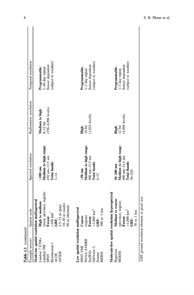
Table 1.1
(continued)
Example sensors
Spatial scale
Spectral resolution
Radiometric resolution
Temporal resolution
Moderate spatial resolution multispectral
Landsat 7 ETM+
Landsat TM
SPOT
Resourcesat-1
ALOS
ASTER
High to medium:
(local, province, region)
Extent:
[100
km
2
GRE:
2.5–15 m (pan)
10–30 m (multi)
90 m (thermal)
[100 nm
Medium to high range:
450 nm–12.5 um
Total bands:
3–14
Medium to high:
8–12 bit
(256–4,096 levels)
Programmable:
1–46 day repeat
Sensor dependent
(subject to weather)
Low spatial resolution multispectral
SPOT VMI
NOAA AVHRR
SeaWifs
OrbView-2
Seastar
MERIS
Coarse:
(region)
Extent:
[1,000
km
2
GRE:
300 m–1 km
[50 nm
Medium to high range:
400 nm–12.5 um
Total bands:
4–15
High:
10 bit
(1,024 levels)
Programmable:
1–3 day repeat
Sensor dependent
(subject to weather)
Moderate-low spatial resolution hyperspectral
Hyperion
MODIS
Medium to coarse:
(province, region)
Extent:
[1,000
km
2
GRE:
30 m–1 km
10–100 nm
Medium to high range:
400 nm–14.4 um
Total Bands:
36–220
High:
12 bit
(4,096 levels)
Programmable:
1–3 day repeat
Sensor dependent
(subject to weather)
GRE
ground resolution element or pixel size
8
S. R. Phinn et al.
(continued)
Example sensors
Spatial scale
Spectral resolution
Radiometric resolution
Temporal resolution
Moderate spatial resolution multispectral
Landsat 7 ETM+
Landsat TM
SPOT
Resourcesat-1
ALOS
ASTER
High to medium:
(local, province, region)
Extent:
[100
km
2
GRE:
2.5–15 m (pan)
10–30 m (multi)
90 m (thermal)
[100 nm
Medium to high range:
450 nm–12.5 um
Total bands:
3–14
Medium to high:
8–12 bit
(256–4,096 levels)
Programmable:
1–46 day repeat
Sensor dependent
(subject to weather)
Low spatial resolution multispectral
SPOT VMI
NOAA AVHRR
SeaWifs
OrbView-2
Seastar
MERIS
Coarse:
(region)
Extent:
[1,000
km
2
GRE:
300 m–1 km
[50 nm
Medium to high range:
400 nm–12.5 um
Total bands:
4–15
High:
10 bit
(1,024 levels)
Programmable:
1–3 day repeat
Sensor dependent
(subject to weather)
Moderate-low spatial resolution hyperspectral
Hyperion
MODIS
Medium to coarse:
(province, region)
Extent:
[1,000
km
2
GRE:
30 m–1 km
10–100 nm
Medium to high range:
400 nm–14.4 um
Total Bands:
36–220
High:
12 bit
(4,096 levels)
Programmable:
1–3 day repeat
Sensor dependent
(subject to weather)
GRE
ground resolution element or pixel size
8
S. R. Phinn et al.