

Without accurate topographic information, however, it can be difficult to reconcile
variations observed between video transects and seabed acoustic response in a
cold-water coral habitat (Dolan et al. 2008). In summary, despite the large coverage and the high resolution of the maps acquired using deep-towed SSS, the use
of this sensor alone is not an efficient approach for mapping cold-water corals due
to poor positioning accuracy, lack of topographic data, and operational challenges
related to this type of survey.
Multi-beam sonar is a more recent system used for mapping cold-water coral
habitats. Multi-beam systems have traditionally been hull-mounted on the mother
ship (Roberts et al. 2005; Dolan et al. 2008; Guinan et al. 2009) and more recently
on ROV (i.e., remotely operated vehicle; Foubert et al. 2011). Multi-beam systems
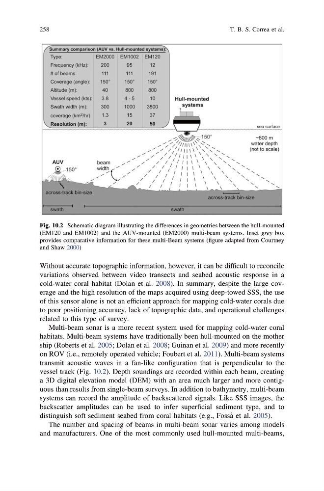
transmit acoustic waves in a fan-like configuration that is perpendicular to the
vessel track (Fig. 10.2). Depth soundings are recorded within each beam, creating
a 3D digital elevation model (DEM) with an area much larger and more contiguous than results from single-beam surveys. In addition to bathymetry, multi-beam
systems can record the amplitude of backscattered signals. Like SSS images, the
backscatter amplitudes can be used to infer superficial sediment type, and to
distinguish soft sediment seabed from coral habitats (e.g., Fosså et al. 2005).
The number and spacing of beams in multi-beam sonar varies among models
and manufacturers. One of the most commonly used hull-mounted multi-beams,
Fig. 10.2 Schematic diagram illustrating the differences in geometries between the hull-mounted
(EM120 and EM1002) and the AUV-mounted (EM2000) multi-beam systems. Inset grey box
provides comparative information for these multi-Beam systems (figure adapted from Courtney
and Shaw 2000)
258
T. B. S. Correa et al.
variations observed between video transects and seabed acoustic response in a
cold-water coral habitat (Dolan et al. 2008). In summary, despite the large coverage and the high resolution of the maps acquired using deep-towed SSS, the use
of this sensor alone is not an efficient approach for mapping cold-water corals due
to poor positioning accuracy, lack of topographic data, and operational challenges
related to this type of survey.
Multi-beam sonar is a more recent system used for mapping cold-water coral
habitats. Multi-beam systems have traditionally been hull-mounted on the mother
ship (Roberts et al. 2005; Dolan et al. 2008; Guinan et al. 2009) and more recently
on ROV (i.e., remotely operated vehicle; Foubert et al. 2011). Multi-beam systems
transmit acoustic waves in a fan-like configuration that is perpendicular to the
vessel track (Fig. 10.2). Depth soundings are recorded within each beam, creating
a 3D digital elevation model (DEM) with an area much larger and more contiguous than results from single-beam surveys. In addition to bathymetry, multi-beam
systems can record the amplitude of backscattered signals. Like SSS images, the
backscatter amplitudes can be used to infer superficial sediment type, and to
distinguish soft sediment seabed from coral habitats (e.g., Fosså et al. 2005).
The number and spacing of beams in multi-beam sonar varies among models
and manufacturers. One of the most commonly used hull-mounted multi-beams,
Fig. 10.2 Schematic diagram illustrating the differences in geometries between the hull-mounted
(EM120 and EM1002) and the AUV-mounted (EM2000) multi-beam systems. Inset grey box
provides comparative information for these multi-Beam systems (figure adapted from Courtney
and Shaw 2000)
258
T. B. S. Correa et al.