

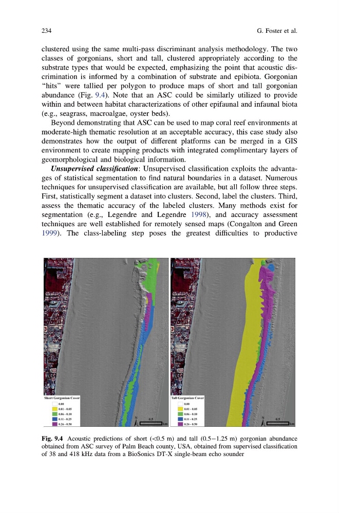
clustered using the same multi-pass discriminant analysis methodology. The two
classes of gorgonians, short and tall, clustered appropriately according to the
substrate types that would be expected, emphasizing the point that acoustic discrimination is informed by a combination of substrate and epibiota. Gorgonian
‘‘hits’’ were tallied per polygon to produce maps of short and tall gorgonian
abundance (Fig. 9.4). Note that an ASC could be similarly utilized to provide
within and between habitat characterizations of other epifaunal and infaunal biota
(e.g., seagrass, macroalgae, oyster beds).
Beyond demonstrating that ASC can be used to map coral reef environments at
moderate-high thematic resolution at an acceptable accuracy, this case study also
demonstrates how the output of different platforms can be merged in a GIS
environment to create mapping products with integrated complimentary layers of
geomorphological and biological information.
Unsupervised classification: Unsupervised classification exploits the advantages of statistical segmentation to find natural boundaries in a dataset. Numerous
techniques for unsupervised classification are available, but all follow three steps.
First, statistically segment a dataset into clusters. Second, label the clusters. Third,
assess the thematic accuracy of the labeled clusters. Many methods exist for
segmentation (e.g., Legendre and Legendre 1998), and accuracy assessment
techniques are well established for remotely sensed maps (Congalton and Green
1999). The class-labeling step poses the greatest difficulties to productive
Fig. 9.4 Acoustic predictions of short (\0.5 m) and tall (0.5-1.25 m) gorgonian abundance
obtained from ASC survey of Palm Beach county, USA, obtained from supervised classification
of 38 and 418 kHz data from a BioSonics DT-X single-beam echo sounder
234
G. Foster et al.
classes of gorgonians, short and tall, clustered appropriately according to the
substrate types that would be expected, emphasizing the point that acoustic discrimination is informed by a combination of substrate and epibiota. Gorgonian
‘‘hits’’ were tallied per polygon to produce maps of short and tall gorgonian
abundance (Fig. 9.4). Note that an ASC could be similarly utilized to provide
within and between habitat characterizations of other epifaunal and infaunal biota
(e.g., seagrass, macroalgae, oyster beds).
Beyond demonstrating that ASC can be used to map coral reef environments at
moderate-high thematic resolution at an acceptable accuracy, this case study also
demonstrates how the output of different platforms can be merged in a GIS
environment to create mapping products with integrated complimentary layers of
geomorphological and biological information.
Unsupervised classification: Unsupervised classification exploits the advantages of statistical segmentation to find natural boundaries in a dataset. Numerous
techniques for unsupervised classification are available, but all follow three steps.
First, statistically segment a dataset into clusters. Second, label the clusters. Third,
assess the thematic accuracy of the labeled clusters. Many methods exist for
segmentation (e.g., Legendre and Legendre 1998), and accuracy assessment
techniques are well established for remotely sensed maps (Congalton and Green
1999). The class-labeling step poses the greatest difficulties to productive
Fig. 9.4 Acoustic predictions of short (\0.5 m) and tall (0.5-1.25 m) gorgonian abundance
obtained from ASC survey of Palm Beach county, USA, obtained from supervised classification
of 38 and 418 kHz data from a BioSonics DT-X single-beam echo sounder
234
G. Foster et al.