

signal polarisation (Guenther 2007). And since the speed of light is different in air
and water, knowledge of the distance to the water surface improves the overall
ranging accuracy of the LiDAR system. In addition, specific LiDAR instruments,
for example the Optech SHOALS system, record the red wavelength water Raman
signal (647 nm). The water Raman signal derives from interactions between the
blue-green laser and H 2 O molecules that cause part of the energy to be backscattered while changing wavelength (Guenther et al. 1994). Recording the Raman
signal provides another means of identifying the water surface and can be used to
identify incorrect surface detections that may arise due to land reflection or the
presence of unexpected targets, such as birds.
As demonstrated by both SHOALS and the EAARL, one of the key advances in
the development of bathymetric LiDAR systems has been the ability to survey
across the littoral zone through the seamless acquisition of near-shore topography
and shallow bathymetry with a single system on a single survey (LaRocque and
West 1990; Irish and Lillycrop 1999; Guenther et al. 2000; Wozencraft 2003). As
discussed, this objective can now be achieved through use of single- or dual-laser
technology. Acquisition of terrestrial and bathymetric data using a single system
considerably reduces the cost and increases the utility of LiDAR.
While both the EAARL and a dual-wavelength LiDAR offer near-unbroken
profiles between seabed topography and terrestrial terrain, neither system can
acquire dependable bathymetric data in the near-shore or surf zone. When whitecaps are present, the laser does not penetrate the water column. Even when the
water surface is clear, if the depth is less than 2 m, systems that employ relatively
long transmitted pulse lengths ([10 ns) are not capable of separating the peak in
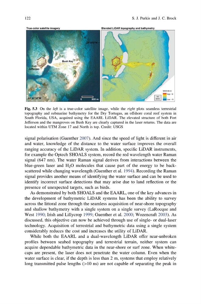
Fig. 5.3 On the left is a true-color satellite image, while the right plots seamless terrestrial
topography and submarine bathymetry for the Dry Tortugas, an offshore coral reef system in
South Florida, USA, acquired using the EAARL LiDAR. The elevated structure of both Fort
Jefferson and the mangroves on Bush Key are clearly captured in the laser returns. The data are
located within UTM Zone 17 and North is top. Credit: USGS
122
S. J. Purkis and J. C. Brock
and water, knowledge of the distance to the water surface improves the overall
ranging accuracy of the LiDAR system. In addition, specific LiDAR instruments,
for example the Optech SHOALS system, record the red wavelength water Raman
signal (647 nm). The water Raman signal derives from interactions between the
blue-green laser and H 2 O molecules that cause part of the energy to be backscattered while changing wavelength (Guenther et al. 1994). Recording the Raman
signal provides another means of identifying the water surface and can be used to
identify incorrect surface detections that may arise due to land reflection or the
presence of unexpected targets, such as birds.
As demonstrated by both SHOALS and the EAARL, one of the key advances in
the development of bathymetric LiDAR systems has been the ability to survey
across the littoral zone through the seamless acquisition of near-shore topography
and shallow bathymetry with a single system on a single survey (LaRocque and
West 1990; Irish and Lillycrop 1999; Guenther et al. 2000; Wozencraft 2003). As
discussed, this objective can now be achieved through use of single- or dual-laser
technology. Acquisition of terrestrial and bathymetric data using a single system
considerably reduces the cost and increases the utility of LiDAR.
While both the EAARL and a dual-wavelength LiDAR offer near-unbroken
profiles between seabed topography and terrestrial terrain, neither system can
acquire dependable bathymetric data in the near-shore or surf zone. When whitecaps are present, the laser does not penetrate the water column. Even when the
water surface is clear, if the depth is less than 2 m, systems that employ relatively
long transmitted pulse lengths ([10 ns) are not capable of separating the peak in
Fig. 5.3 On the left is a true-color satellite image, while the right plots seamless terrestrial
topography and submarine bathymetry for the Dry Tortugas, an offshore coral reef system in
South Florida, USA, acquired using the EAARL LiDAR. The elevated structure of both Fort
Jefferson and the mangroves on Bush Key are clearly captured in the laser returns. The data are
located within UTM Zone 17 and North is top. Credit: USGS
122
S. J. Purkis and J. C. Brock