

Remote Sensor Data” (Anderson et al. 1976) the classification design in this study
has been determined at a mixed USGS Level I/II based on the consideration of
spectral and spatial resolution of Landsat image. With visual interpretation and
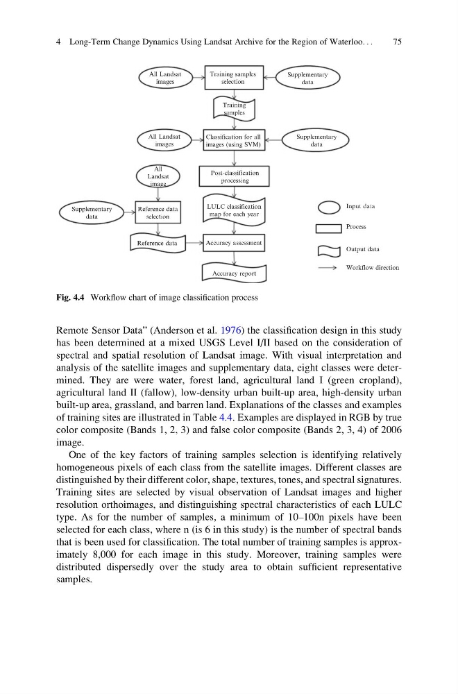
analysis of the satellite images and supplementary data, eight classes were determined. They are were water, forest land, agricultural land I (green cropland),
agricultural land II (fallow), low-density urban built-up area, high-density urban
built-up area, grassland, and barren land. Explanations of the classes and examples
of training sites are illustrated in Table 4.4. Examples are displayed in RGB by true
color composite (Bands 1, 2, 3) and false color composite (Bands 2, 3, 4) of 2006
image.
One of the key factors of training samples selection is identifying relatively
homogeneous pixels of each class from the satellite images. Different classes are
distinguished by their different color, shape, textures, tones, and spectral signatures.
Training sites are selected by visual observation of Landsat images and higher
resolution orthoimages, and distinguishing spectral characteristics of each LULC
type. As for the number of samples, a minimum of 10–100n pixels have been
selected for each class, where n (is 6 in this study) is the number of spectral bands
that is been used for classification. The total number of training samples is approximately 8,000 for each image in this study. Moreover, training samples were
distributed dispersedly over the study area to obtain sufficient representative
samples.
Supplementary
data
Reference data
Reference data
selection
All
Landsat
image
All Landsat
images
All Landsat
images
Training samples
selection
Training
samples
Classification for all
images (using SVM)
Post-classification
processing
LULC classification
map for each year
Accuracy assessment
Accuracy report
Workflow direction
Output data
Input data
Process
Supplementary
data
Supplementary
data
Fig. 4.4 Workflow chart of image classification process
4 Long-Term Change Dynamics Using Landsat Archive for the Region of Waterloo. . .
75
has been determined at a mixed USGS Level I/II based on the consideration of
spectral and spatial resolution of Landsat image. With visual interpretation and
analysis of the satellite images and supplementary data, eight classes were determined. They are were water, forest land, agricultural land I (green cropland),
agricultural land II (fallow), low-density urban built-up area, high-density urban
built-up area, grassland, and barren land. Explanations of the classes and examples
of training sites are illustrated in Table 4.4. Examples are displayed in RGB by true
color composite (Bands 1, 2, 3) and false color composite (Bands 2, 3, 4) of 2006
image.
One of the key factors of training samples selection is identifying relatively
homogeneous pixels of each class from the satellite images. Different classes are
distinguished by their different color, shape, textures, tones, and spectral signatures.
Training sites are selected by visual observation of Landsat images and higher
resolution orthoimages, and distinguishing spectral characteristics of each LULC
type. As for the number of samples, a minimum of 10–100n pixels have been
selected for each class, where n (is 6 in this study) is the number of spectral bands
that is been used for classification. The total number of training samples is approximately 8,000 for each image in this study. Moreover, training samples were
distributed dispersedly over the study area to obtain sufficient representative
samples.
Supplementary
data
Reference data
Reference data
selection
All
Landsat
image
All Landsat
images
All Landsat
images
Training samples
selection
Training
samples
Classification for all
images (using SVM)
Post-classification
processing
LULC classification
map for each year
Accuracy assessment
Accuracy report
Workflow direction
Output data
Input data
Process
Supplementary
data
Supplementary
data
Fig. 4.4 Workflow chart of image classification process
4 Long-Term Change Dynamics Using Landsat Archive for the Region of Waterloo. . .
75