

3.3.4 Citadel Information System
A virtual model of the citadel was created based on image data processing (Meyer
et al. 2007). Terrestrial, aerial and satellite data has been used. All 3D constructions
were created in Photomodeler software and supplemented and edited in AutoCAD
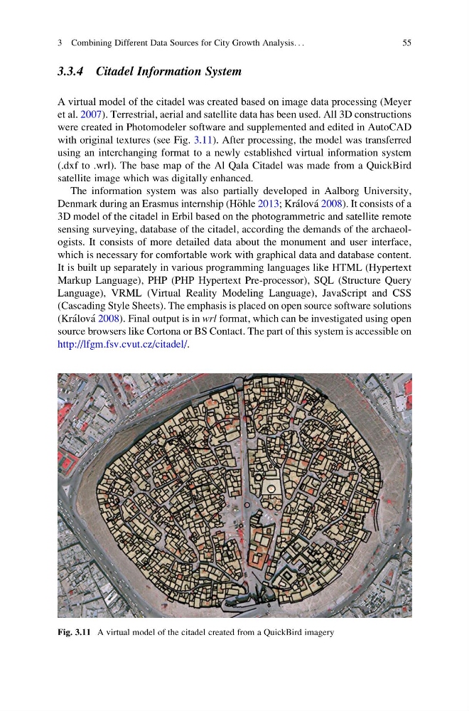
with original textures (see Fig. 3.11). After processing, the model was transferred
using an interchanging format to a newly established virtual information system
(.dxf to .wrl). The base map of the Al Qala Citadel was made from a QuickBird
satellite image which was digitally enhanced.
The information system was also partially developed in Aalborg University,
Denmark during an Erasmus internship (H€ ohle 2013; Kra ´lova ´ 2008). It consists of a
3D model of the citadel in Erbil based on the photogrammetric and satellite remote
sensing surveying, database of the citadel, according the demands of the archaeologists. It consists of more detailed data about the monument and user interface,
which is necessary for comfortable work with graphical data and database content.
It is built up separately in various programming languages like HTML (Hypertext
Markup Language), PHP (PHP Hypertext Pre-processor), SQL (Structure Query
Language), VRML (Virtual Reality Modeling Language), JavaScript and CSS
(Cascading Style Sheets). The emphasis is placed on open source software solutions
(Kra ´lova ´ 2008). Final output is in wrl format, which can be investigated using open
source browsers like Cortona or BS Contact. The part of this system is accessible on
http://lfgm.fsv.cvut.cz/citadel/.
Fig. 3.11 A virtual model of the citadel created from a QuickBird imagery
3 Combining Different Data Sources for City Growth Analysis. . .
55
A virtual model of the citadel was created based on image data processing (Meyer
et al. 2007). Terrestrial, aerial and satellite data has been used. All 3D constructions
were created in Photomodeler software and supplemented and edited in AutoCAD
with original textures (see Fig. 3.11). After processing, the model was transferred
using an interchanging format to a newly established virtual information system
(.dxf to .wrl). The base map of the Al Qala Citadel was made from a QuickBird
satellite image which was digitally enhanced.
The information system was also partially developed in Aalborg University,
Denmark during an Erasmus internship (H€ ohle 2013; Kra ´lova ´ 2008). It consists of a
3D model of the citadel in Erbil based on the photogrammetric and satellite remote
sensing surveying, database of the citadel, according the demands of the archaeologists. It consists of more detailed data about the monument and user interface,
which is necessary for comfortable work with graphical data and database content.
It is built up separately in various programming languages like HTML (Hypertext
Markup Language), PHP (PHP Hypertext Pre-processor), SQL (Structure Query
Language), VRML (Virtual Reality Modeling Language), JavaScript and CSS
(Cascading Style Sheets). The emphasis is placed on open source software solutions
(Kra ´lova ´ 2008). Final output is in wrl format, which can be investigated using open
source browsers like Cortona or BS Contact. The part of this system is accessible on
http://lfgm.fsv.cvut.cz/citadel/.
Fig. 3.11 A virtual model of the citadel created from a QuickBird imagery
3 Combining Different Data Sources for City Growth Analysis. . .
55