

hierarchical cluster analyses techniques are; the single linkage clustering method,
complete linkage clustering method, Ward’s clustering method, WPGMA
(weighted pair-group method using arithmetic average) and UPGMA (unweighted
pair-group method using arithmetic average) (Sneath and Sokal 1973; Romesburg
1989).
The calculated dendrogram is assessed by the CPCC (cophenetic correlation
coefficient) (Sneath and Sokal 1973). CPCC is the coefficient of correlation
between the similarity matrix (or the dissimilarity matrix) and cluster topology,
arrived at by calculating the data. If CPCC is near 1, the topology is a highly
reproducible result. Because UPGMA is simple and useful and shows the higher
CPCC (Farris 1969), it is considered a highly reproducible cluster analysis.
In the numerical vulnerability estimation, the shoreline is divided into
108 meshes. These shoreline meshes are called an Operational Taxonomic Unit
(OTU) and the intermediate node is called a Hypothetical Taxonomic Unit (HTU).
Here, the Pearson’s product moment correlation coefficient is used as the similarity.
UPGMA algorithm is expressed as follows:
i, j, k, l, m k , m l , n and N are natural numbers and S is a real symmetric square
matrix of order N.
1. Substitute n for N and calculate a similarity matrix S.
2. Select a taxonomic unit (TU) pair, i and j, with a maximum similarity value
S(i, j).
3. Replace a TU pair to HTU k. Substitute N-1 for N and update the similarity
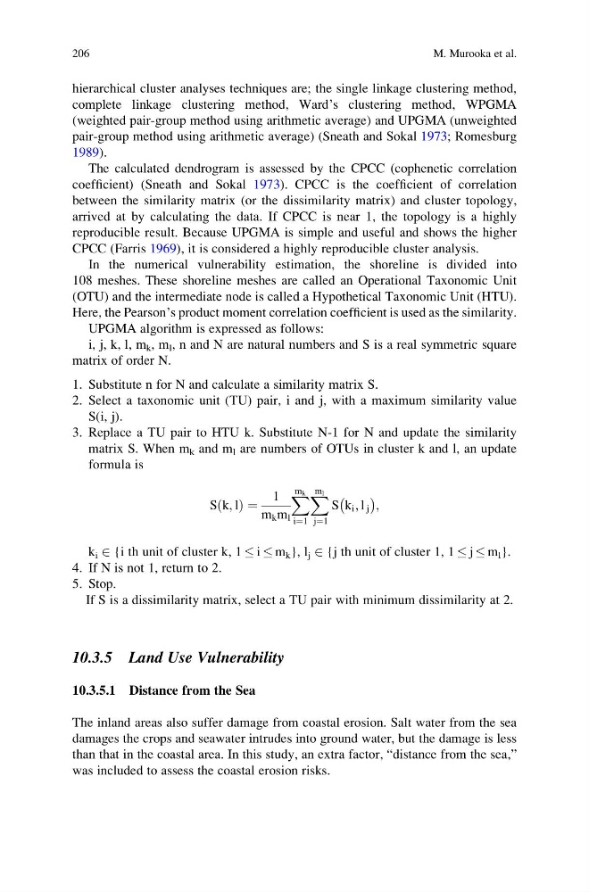
matrix S. When m k and m l are numbers of OTUs in cluster k and l, an update
formula is
S k; l
ð Þ ¼
1
m k m l
X m k
i¼1
X m l
j¼1
S k i ; l j
À
Á ;
k i 2 {i th unit of cluster k, 1 i m k }, l j 2 {j th unit of cluster 1, 1 j m l }.
4. If N is not 1, return to 2.
5. Stop.
If S is a dissimilarity matrix, select a TU pair with minimum dissimilarity at 2.
10.3.5 Land Use Vulnerability
10.3.5.1 Distance from the Sea
The inland areas also suffer damage from coastal erosion. Salt water from the sea
damages the crops and seawater intrudes into ground water, but the damage is less
than that in the coastal area. In this study, an extra factor, “distance from the sea,”
was included to assess the coastal erosion risks.
206
M. Murooka et al.
complete linkage clustering method, Ward’s clustering method, WPGMA
(weighted pair-group method using arithmetic average) and UPGMA (unweighted
pair-group method using arithmetic average) (Sneath and Sokal 1973; Romesburg
1989).
The calculated dendrogram is assessed by the CPCC (cophenetic correlation
coefficient) (Sneath and Sokal 1973). CPCC is the coefficient of correlation
between the similarity matrix (or the dissimilarity matrix) and cluster topology,
arrived at by calculating the data. If CPCC is near 1, the topology is a highly
reproducible result. Because UPGMA is simple and useful and shows the higher
CPCC (Farris 1969), it is considered a highly reproducible cluster analysis.
In the numerical vulnerability estimation, the shoreline is divided into
108 meshes. These shoreline meshes are called an Operational Taxonomic Unit
(OTU) and the intermediate node is called a Hypothetical Taxonomic Unit (HTU).
Here, the Pearson’s product moment correlation coefficient is used as the similarity.
UPGMA algorithm is expressed as follows:
i, j, k, l, m k , m l , n and N are natural numbers and S is a real symmetric square
matrix of order N.
1. Substitute n for N and calculate a similarity matrix S.
2. Select a taxonomic unit (TU) pair, i and j, with a maximum similarity value
S(i, j).
3. Replace a TU pair to HTU k. Substitute N-1 for N and update the similarity
matrix S. When m k and m l are numbers of OTUs in cluster k and l, an update
formula is
S k; l
ð Þ ¼
1
m k m l
X m k
i¼1
X m l
j¼1
S k i ; l j
À
Á ;
k i 2 {i th unit of cluster k, 1 i m k }, l j 2 {j th unit of cluster 1, 1 j m l }.
4. If N is not 1, return to 2.
5. Stop.
If S is a dissimilarity matrix, select a TU pair with minimum dissimilarity at 2.
10.3.5 Land Use Vulnerability
10.3.5.1 Distance from the Sea
The inland areas also suffer damage from coastal erosion. Salt water from the sea
damages the crops and seawater intrudes into ground water, but the damage is less
than that in the coastal area. In this study, an extra factor, “distance from the sea,”
was included to assess the coastal erosion risks.
206
M. Murooka et al.