

Aerial survey 2003 Color-positive photographs were acquired in three adjacent
flight strips oriented parallel to the main axis of the glacier tongue of Pasterze
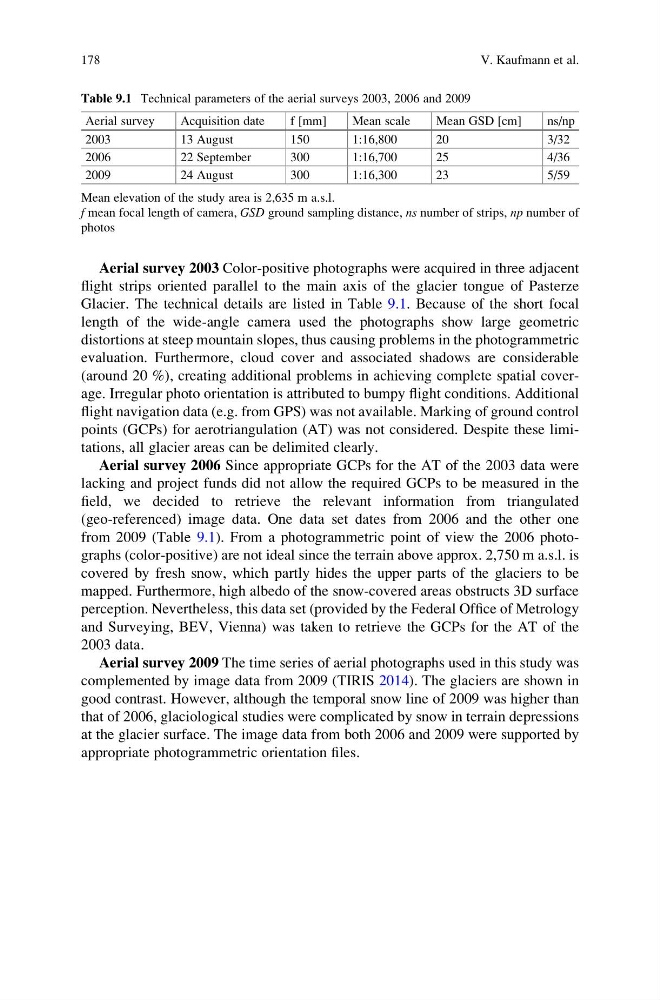
Glacier. The technical details are listed in Table 9.1. Because of the short focal
length of the wide-angle camera used the photographs show large geometric
distortions at steep mountain slopes, thus causing problems in the photogrammetric
evaluation. Furthermore, cloud cover and associated shadows are considerable
(around 20 %), creating additional problems in achieving complete spatial coverage. Irregular photo orientation is attributed to bumpy flight conditions. Additional
flight navigation data (e.g. from GPS) was not available. Marking of ground control
points (GCPs) for aerotriangulation (AT) was not considered. Despite these limitations, all glacier areas can be delimited clearly.
Aerial survey 2006 Since appropriate GCPs for the AT of the 2003 data were
lacking and project funds did not allow the required GCPs to be measured in the
field, we decided to retrieve the relevant information from triangulated
(geo-referenced) image data. One data set dates from 2006 and the other one
from 2009 (Table 9.1). From a photogrammetric point of view the 2006 photographs (color-positive) are not ideal since the terrain above approx. 2,750 m a.s.l. is
covered by fresh snow, which partly hides the upper parts of the glaciers to be
mapped. Furthermore, high albedo of the snow-covered areas obstructs 3D surface
perception. Nevertheless, this data set (provided by the Federal Office of Metrology
and Surveying, BEV, Vienna) was taken to retrieve the GCPs for the AT of the
2003 data.
Aerial survey 2009 The time series of aerial photographs used in this study was
complemented by image data from 2009 (TIRIS 2014). The glaciers are shown in
good contrast. However, although the temporal snow line of 2009 was higher than
that of 2006, glaciological studies were complicated by snow in terrain depressions
at the glacier surface. The image data from both 2006 and 2009 were supported by
appropriate photogrammetric orientation files.
Table 9.1 Technical parameters of the aerial surveys 2003, 2006 and 2009
Aerial survey
Acquisition date
f [mm]
Mean scale
Mean GSD [cm]
ns/np
2003
13 August
150
1:16,800
20
3/32
2006
22 September
300
1:16,700
25
4/36
2009
24 August
300
1:16,300
23
5/59
Mean elevation of the study area is 2,635 m a.s.l.
f mean focal length of camera, GSD ground sampling distance, ns number of strips, np number of
photos
178
V. Kaufmann et al.
flight strips oriented parallel to the main axis of the glacier tongue of Pasterze
Glacier. The technical details are listed in Table 9.1. Because of the short focal
length of the wide-angle camera used the photographs show large geometric
distortions at steep mountain slopes, thus causing problems in the photogrammetric
evaluation. Furthermore, cloud cover and associated shadows are considerable
(around 20 %), creating additional problems in achieving complete spatial coverage. Irregular photo orientation is attributed to bumpy flight conditions. Additional
flight navigation data (e.g. from GPS) was not available. Marking of ground control
points (GCPs) for aerotriangulation (AT) was not considered. Despite these limitations, all glacier areas can be delimited clearly.
Aerial survey 2006 Since appropriate GCPs for the AT of the 2003 data were
lacking and project funds did not allow the required GCPs to be measured in the
field, we decided to retrieve the relevant information from triangulated
(geo-referenced) image data. One data set dates from 2006 and the other one
from 2009 (Table 9.1). From a photogrammetric point of view the 2006 photographs (color-positive) are not ideal since the terrain above approx. 2,750 m a.s.l. is
covered by fresh snow, which partly hides the upper parts of the glaciers to be
mapped. Furthermore, high albedo of the snow-covered areas obstructs 3D surface
perception. Nevertheless, this data set (provided by the Federal Office of Metrology
and Surveying, BEV, Vienna) was taken to retrieve the GCPs for the AT of the
2003 data.
Aerial survey 2009 The time series of aerial photographs used in this study was
complemented by image data from 2009 (TIRIS 2014). The glaciers are shown in
good contrast. However, although the temporal snow line of 2009 was higher than
that of 2006, glaciological studies were complicated by snow in terrain depressions
at the glacier surface. The image data from both 2006 and 2009 were supported by
appropriate photogrammetric orientation files.
Table 9.1 Technical parameters of the aerial surveys 2003, 2006 and 2009
Aerial survey
Acquisition date
f [mm]
Mean scale
Mean GSD [cm]
ns/np
2003
13 August
150
1:16,800
20
3/32
2006
22 September
300
1:16,700
25
4/36
2009
24 August
300
1:16,300
23
5/59
Mean elevation of the study area is 2,635 m a.s.l.
f mean focal length of camera, GSD ground sampling distance, ns number of strips, np number of
photos
178
V. Kaufmann et al.