

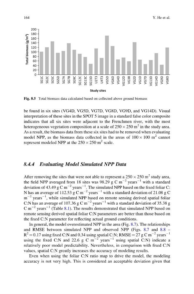
be found in six sites (VG4D, VG5D, VG7D, VG8D, VG9D, and VG14D). Visual
interpretation of these sites in the SPOT 5 image in a standard false color composite
indicates that all six sites were adjacent to the Frenchmen river, with the most
heterogeneous vegetation composition at a scale of 250 Â 250 m
2 in the study area.
As a result, the biomass data from these six sites had to be removed when evaluating
model NPP, as the biomass data collected in the areas of 100 Â 100 m
2 cannot
represent modeled NPP at the 250 Â 250 m
2 scale.
8.4.4 Evaluating Model Simulated NPP Data
After removing the sites that were not able to represent a 250 Â 250 m
2 study area,
the field NPP averaged from 18 sites was 98.29 g C m
À2 years
À1 with a standard
deviation of 43.49 g C m
À2 years
À1 . The simulated NPP based on the fixed foliar C:
N has an average of 112.53 g C m
À2 years
À1 with a standard deviation of 21.08 g C
m
À2 years
À1 , while simulated NPP based on remote sensing derived spatial foliar
C:N has an average of 107.36 g C m
À2 years
À1 with a standard deviation of 35.38 g
C m
À2 years
À1 (Table 8.1). The results demonstrated that simulated NPP based on
remote sensing derived spatial foliar C:N parameters are better than those based on
the fixed C:N parameter for reflecting actual ground conditions.
In general, the model overestimated NPP in the area (Fig. 8.7). The relationships
and RMSE between simulated NPP and observed NPP (Figs. 8.7 and 8.8 –
R
2
¼ 0.17 using fixed C:N and 0.34 using spatial C:N; RMSE ¼ 27 g C m
À2 years
À1
using the fixed C:N and 22.6 g C m
À2 years
À1 using spatial C:N) indicate a
relatively poor model predictability. Nevertheless, in comparison with fixed C:N
values, spatial C:N greatly increases the accuracy of modeling results.
Even when using the foliar C:N ratio map to drive the model, the modeling
accuracy is not very high. This is considered an acceptable deviation given that
200
180
160
140
120
100
80
60
40
20
0
SG1C
SG2C
SG5C
SG5D
SG7A
SG7B
SG9C
SG12C
SG13C
SG13D
U2T3
U4T3
VG5D
VG6D
Study sites
Total biomass (g/m
2
)
VG4D
VG12D
VG3B
VG2D
VG1D
VG7D
VG13D
VG14D
VG9D
VG8D
Fig. 8.5 Total biomass data calculated based on collected above ground biomass
164
Y. He et al.
interpretation of these sites in the SPOT 5 image in a standard false color composite
indicates that all six sites were adjacent to the Frenchmen river, with the most
heterogeneous vegetation composition at a scale of 250 Â 250 m
2 in the study area.
As a result, the biomass data from these six sites had to be removed when evaluating
model NPP, as the biomass data collected in the areas of 100 Â 100 m
2 cannot
represent modeled NPP at the 250 Â 250 m
2 scale.
8.4.4 Evaluating Model Simulated NPP Data
After removing the sites that were not able to represent a 250 Â 250 m
2 study area,
the field NPP averaged from 18 sites was 98.29 g C m
À2 years
À1 with a standard
deviation of 43.49 g C m
À2 years
À1 . The simulated NPP based on the fixed foliar C:
N has an average of 112.53 g C m
À2 years
À1 with a standard deviation of 21.08 g C
m
À2 years
À1 , while simulated NPP based on remote sensing derived spatial foliar
C:N has an average of 107.36 g C m
À2 years
À1 with a standard deviation of 35.38 g
C m
À2 years
À1 (Table 8.1). The results demonstrated that simulated NPP based on
remote sensing derived spatial foliar C:N parameters are better than those based on
the fixed C:N parameter for reflecting actual ground conditions.
In general, the model overestimated NPP in the area (Fig. 8.7). The relationships
and RMSE between simulated NPP and observed NPP (Figs. 8.7 and 8.8 –
R
2
¼ 0.17 using fixed C:N and 0.34 using spatial C:N; RMSE ¼ 27 g C m
À2 years
À1
using the fixed C:N and 22.6 g C m
À2 years
À1 using spatial C:N) indicate a
relatively poor model predictability. Nevertheless, in comparison with fixed C:N
values, spatial C:N greatly increases the accuracy of modeling results.
Even when using the foliar C:N ratio map to drive the model, the modeling
accuracy is not very high. This is considered an acceptable deviation given that
200
180
160
140
120
100
80
60
40
20
0
SG1C
SG2C
SG5C
SG5D
SG7A
SG7B
SG9C
SG12C
SG13C
SG13D
U2T3
U4T3
VG5D
VG6D
Study sites
Total biomass (g/m
2
)
VG4D
VG12D
VG3B
VG2D
VG1D
VG7D
VG13D
VG14D
VG9D
VG8D
Fig. 8.5 Total biomass data calculated based on collected above ground biomass
164
Y. He et al.