

6.2 Principle of SAR Imaging
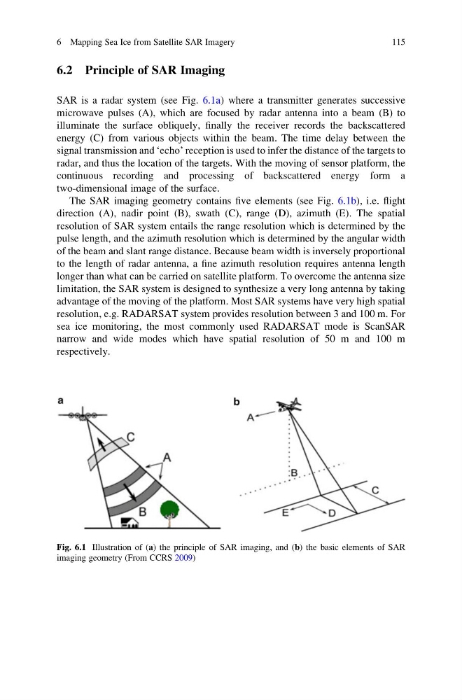
SAR is a radar system (see Fig. 6.1a) where a transmitter generates successive
microwave pulses (A), which are focused by radar antenna into a beam (B) to
illuminate the surface obliquely, finally the receiver records the backscattered
energy (C) from various objects within the beam. The time delay between the
signal transmission and ‘echo’ reception is used to infer the distance of the targets to
radar, and thus the location of the targets. With the moving of sensor platform, the
continuous recording and processing of backscattered energy form a
two-dimensional image of the surface.
The SAR imaging geometry contains five elements (see Fig. 6.1b), i.e. flight
direction (A), nadir point (B), swath (C), range (D), azimuth (E). The spatial
resolution of SAR system entails the range resolution which is determined by the
pulse length, and the azimuth resolution which is determined by the angular width
of the beam and slant range distance. Because beam width is inversely proportional
to the length of radar antenna, a fine azimuth resolution requires antenna length
longer than what can be carried on satellite platform. To overcome the antenna size
limitation, the SAR system is designed to synthesize a very long antenna by taking
advantage of the moving of the platform. Most SAR systems have very high spatial
resolution, e.g. RADARSAT system provides resolution between 3 and 100 m. For
sea ice monitoring, the most commonly used RADARSAT mode is ScanSAR
narrow and wide modes which have spatial resolution of 50 m and 100 m
respectively.
Fig. 6.1 Illustration of (a) the principle of SAR imaging, and (b) the basic elements of SAR
imaging geometry (From CCRS 2009)
6 Mapping Sea Ice from Satellite SAR Imagery
115
SAR is a radar system (see Fig. 6.1a) where a transmitter generates successive
microwave pulses (A), which are focused by radar antenna into a beam (B) to
illuminate the surface obliquely, finally the receiver records the backscattered
energy (C) from various objects within the beam. The time delay between the
signal transmission and ‘echo’ reception is used to infer the distance of the targets to
radar, and thus the location of the targets. With the moving of sensor platform, the
continuous recording and processing of backscattered energy form a
two-dimensional image of the surface.
The SAR imaging geometry contains five elements (see Fig. 6.1b), i.e. flight
direction (A), nadir point (B), swath (C), range (D), azimuth (E). The spatial
resolution of SAR system entails the range resolution which is determined by the
pulse length, and the azimuth resolution which is determined by the angular width
of the beam and slant range distance. Because beam width is inversely proportional
to the length of radar antenna, a fine azimuth resolution requires antenna length
longer than what can be carried on satellite platform. To overcome the antenna size
limitation, the SAR system is designed to synthesize a very long antenna by taking
advantage of the moving of the platform. Most SAR systems have very high spatial
resolution, e.g. RADARSAT system provides resolution between 3 and 100 m. For
sea ice monitoring, the most commonly used RADARSAT mode is ScanSAR
narrow and wide modes which have spatial resolution of 50 m and 100 m
respectively.
Fig. 6.1 Illustration of (a) the principle of SAR imaging, and (b) the basic elements of SAR
imaging geometry (From CCRS 2009)
6 Mapping Sea Ice from Satellite SAR Imagery
115