

68
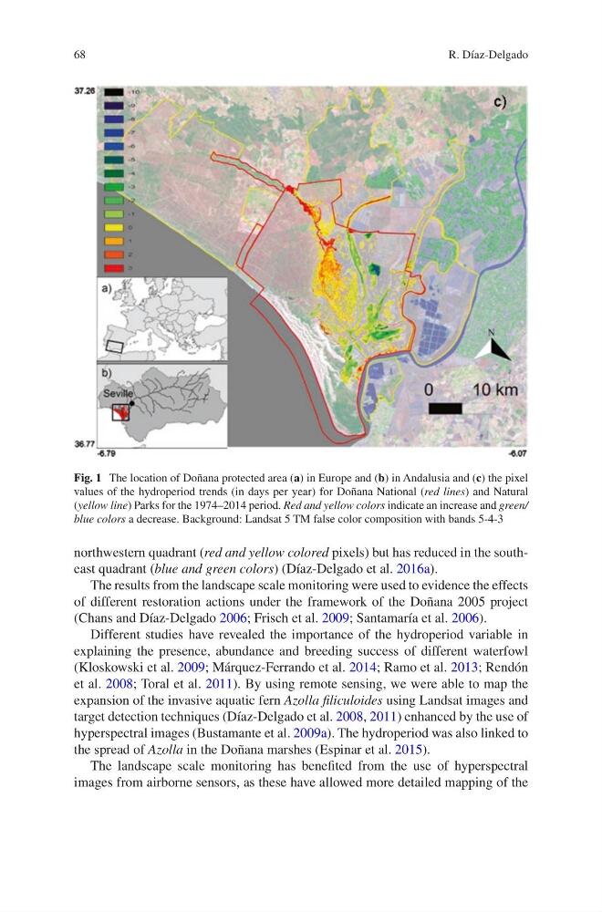
northwestern quadrant (red and yellow colored pixels) but has reduced in the southeast quadrant (blue and green colors) (Díaz-Delgado et al. 2016a).
The results from the landscape scale monitoring were used to evidence the effects
of different restoration actions under the framework of the Doñana 2005 project
(Chans and Díaz-Delgado 2006; Frisch et al. 2009; Santamaría et al. 2006).
Different studies have revealed the importance of the hydroperiod variable in
explaining the presence, abundance and breeding success of different waterfowl
(Kloskowski et al. 2009; Márquez-Ferrando et al. 2014; Ramo et al. 2013; Rendón
et al. 2008; Toral et al. 2011). By using remote sensing, we were able to map the
expansion of the invasive aquatic fern Azolla filiculoides using Landsat images and
target detection techniques (Díaz-Delgado et al. 2008, 2011) enhanced by the use of
hyperspectral images (Bustamante et al. 2009a). The hydroperiod was also linked to
the spread of Azolla in the Doñana marshes (Espinar et al. 2015).
The landscape scale monitoring has benefited from the use of hyperspectral
images from airborne sensors, as these have allowed more detailed mapping of the
Fig. 1 The location of Doñana protected area (a) in Europe and (b) in Andalusia and (c) the pixel
values of the hydroperiod trends (in days per year) for Doñana National (red lines) and Natural
(yellow line) Parks for the 1974–2014 period. Red and yellow colors indicate an increase and green/
blue colors a decrease. Background: Landsat 5 TM false color composition with bands 5-4-3
R. Díaz-Delgado
northwestern quadrant (red and yellow colored pixels) but has reduced in the southeast quadrant (blue and green colors) (Díaz-Delgado et al. 2016a).
The results from the landscape scale monitoring were used to evidence the effects
of different restoration actions under the framework of the Doñana 2005 project
(Chans and Díaz-Delgado 2006; Frisch et al. 2009; Santamaría et al. 2006).
Different studies have revealed the importance of the hydroperiod variable in
explaining the presence, abundance and breeding success of different waterfowl
(Kloskowski et al. 2009; Márquez-Ferrando et al. 2014; Ramo et al. 2013; Rendón
et al. 2008; Toral et al. 2011). By using remote sensing, we were able to map the
expansion of the invasive aquatic fern Azolla filiculoides using Landsat images and
target detection techniques (Díaz-Delgado et al. 2008, 2011) enhanced by the use of
hyperspectral images (Bustamante et al. 2009a). The hydroperiod was also linked to
the spread of Azolla in the Doñana marshes (Espinar et al. 2015).
The landscape scale monitoring has benefited from the use of hyperspectral
images from airborne sensors, as these have allowed more detailed mapping of the
Fig. 1 The location of Doñana protected area (a) in Europe and (b) in Andalusia and (c) the pixel
values of the hydroperiod trends (in days per year) for Doñana National (red lines) and Natural
(yellow line) Parks for the 1974–2014 period. Red and yellow colors indicate an increase and green/
blue colors a decrease. Background: Landsat 5 TM false color composition with bands 5-4-3
R. Díaz-Delgado