

226
would be a major challenge to survey and monitor these TCLs on a regular basis
unless new options for mapping and monitoring their state, condition and dynamics
were developed and implemented.
Determining the Distribution and Abundance of Tigers
Whilst the ecology of wild tigers has been studied in depth (Sanderson et al. 2006),
information on their present status is limited and scattered over a number of publications, with many in the grey literature. In a review conducted in support of this
study, 35 papers were identified that provided information relating specifically to
assessing tiger populations and their habitat, with these based largely on primary
data collection. Approximately half of these studies used capture-recapture methods
with a lesser proportion focusing on sign-based indices (such as tracks, visual estimates, scat DNA analysis; 25%), and satellite tracking (7%). Only one paper (Imam
et al. 2009) explicitly used remote sensing data to assess tiger habitat suitability in
the landscape. The review highlighted the general paucity of information, with only
a few local-scale studies, but also the varied and often inconsistent approaches for
estimating population distributions and sizes. Furthermore, many population estimates were found to be based on single-studies, typically field-based surveys, with
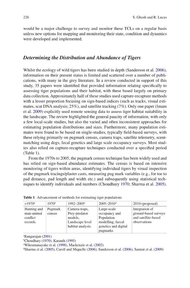
these relying primarily on pugmark census, camera traps, satellite telemetry, scentmatching using dogs, fecal genetics and large scale occupancy surveys. Most studies also relied on capture-recapture techniques conducted over a specified period
(Table 1).
From the 1970s to 2005, the pugmark census technique has been widely used and
has relied on sign-based abundance estimates. The census is based on intensive
monitoring of tigers within areas, identifying individual tigers by visual inspection
of the pugmark tracings/plaster casts, measuring pug mark variables (e.g., for toe to
pad distance, pad length and width etc.) and subsequently using statistical techniques to identify individuals and numbers (Choudhury 1970; Sharma et al. 2005).
Table 1 Advancement of methods for estimating tiger populations
>1970
a
1970
b
1992–2005
c
2005–2010
d
2010-(proposed)
Hunting and
man-animal
conflict
records.
Pugmark
census
Camera-traps,
Prey-predator
models,
Landscape level
habitat analysis.
Large-scale
occupancy and
Population
modelling, faecal
genetics and digital
pugmarks
Integration of
ground-based surveys
and satellite-based
observations
a
Rangarajan (2001)
b
Choudhary (1970), Karanth (1995)
c
Wikramanayake et al. (1998), Mackenzie et al. (2002)
d
Sharma et al. (2005), Caroll and Miquelle (2006), Sanderson et al. (2006), Samrat et al. (2009)
S. Ghosh and R. Lucas
would be a major challenge to survey and monitor these TCLs on a regular basis
unless new options for mapping and monitoring their state, condition and dynamics
were developed and implemented.
Determining the Distribution and Abundance of Tigers
Whilst the ecology of wild tigers has been studied in depth (Sanderson et al. 2006),
information on their present status is limited and scattered over a number of publications, with many in the grey literature. In a review conducted in support of this
study, 35 papers were identified that provided information relating specifically to
assessing tiger populations and their habitat, with these based largely on primary
data collection. Approximately half of these studies used capture-recapture methods
with a lesser proportion focusing on sign-based indices (such as tracks, visual estimates, scat DNA analysis; 25%), and satellite tracking (7%). Only one paper (Imam
et al. 2009) explicitly used remote sensing data to assess tiger habitat suitability in
the landscape. The review highlighted the general paucity of information, with only
a few local-scale studies, but also the varied and often inconsistent approaches for
estimating population distributions and sizes. Furthermore, many population estimates were found to be based on single-studies, typically field-based surveys, with
these relying primarily on pugmark census, camera traps, satellite telemetry, scentmatching using dogs, fecal genetics and large scale occupancy surveys. Most studies also relied on capture-recapture techniques conducted over a specified period
(Table 1).
From the 1970s to 2005, the pugmark census technique has been widely used and
has relied on sign-based abundance estimates. The census is based on intensive
monitoring of tigers within areas, identifying individual tigers by visual inspection
of the pugmark tracings/plaster casts, measuring pug mark variables (e.g., for toe to
pad distance, pad length and width etc.) and subsequently using statistical techniques to identify individuals and numbers (Choudhury 1970; Sharma et al. 2005).
Table 1 Advancement of methods for estimating tiger populations
>1970
a
1970
b
1992–2005
c
2005–2010
d
2010-(proposed)
Hunting and
man-animal
conflict
records.
Pugmark
census
Camera-traps,
Prey-predator
models,
Landscape level
habitat analysis.
Large-scale
occupancy and
Population
modelling, faecal
genetics and digital
pugmarks
Integration of
ground-based surveys
and satellite-based
observations
a
Rangarajan (2001)
b
Choudhary (1970), Karanth (1995)
c
Wikramanayake et al. (1998), Mackenzie et al. (2002)
d
Sharma et al. (2005), Caroll and Miquelle (2006), Sanderson et al. (2006), Samrat et al. (2009)
S. Ghosh and R. Lucas