

178
This was conducted using ArcMap and ERDASimagine, which are both high
cost programmes, so this cannot reflect the feasibility of using open source software, such as QGIS, though this software is rapidly advancing to meet the needs of
users globally. For practical application, even at 62% accuracy, distribution and
temporal changes could be reliably identified provided that Ivy could be reliably
separated. Application of Object Based Image Analysis (OBIA), based on leaf morphology and positioning, has the potential to separate both Ivy and Laurel from R.
ponticum: this has increased vegetation classification accuracy in the literature
(Hernando et al. 2012).
Replicate flights, at other sites and at different times in the year, would quantify
the temporal and inter-site feasibility of either sharing site spectral data or conserving site-specific datasets for achieving the highest accuracy.
Limitations and Cost-Benefit Analysis
UAVs cannot be flown in winds >25 m/s nor in rain which limits their use during
winter months in the UK: this coincides with the optimal time for R. ponticum mapping (Anderson and Gaston 2013). Although aerial flights have a higher tolerance
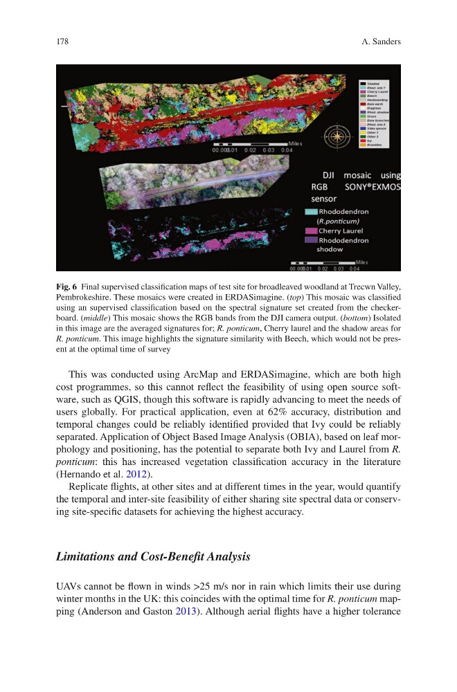
Fig. 6 Final supervised classification maps of test site for broadleaved woodland at Trecwn Valley,
Pembrokeshire. These mosaics were created in ERDASimagine. (top) This mosaic was classified
using an supervised classification based on the spectral signature set created from the checkerboard. (middle) This mosaic shows the RGB bands from the DJI camera output. (bottom) Isolated
in this image are the averaged signatures for; R. ponticum, Cherry laurel and the shadow areas for
R. ponticum. This image highlights the signature similarity with Beech, which would not be present at the optimal time of survey
A. Sanders
This was conducted using ArcMap and ERDASimagine, which are both high
cost programmes, so this cannot reflect the feasibility of using open source software, such as QGIS, though this software is rapidly advancing to meet the needs of
users globally. For practical application, even at 62% accuracy, distribution and
temporal changes could be reliably identified provided that Ivy could be reliably
separated. Application of Object Based Image Analysis (OBIA), based on leaf morphology and positioning, has the potential to separate both Ivy and Laurel from R.
ponticum: this has increased vegetation classification accuracy in the literature
(Hernando et al. 2012).
Replicate flights, at other sites and at different times in the year, would quantify
the temporal and inter-site feasibility of either sharing site spectral data or conserving site-specific datasets for achieving the highest accuracy.
Limitations and Cost-Benefit Analysis
UAVs cannot be flown in winds >25 m/s nor in rain which limits their use during
winter months in the UK: this coincides with the optimal time for R. ponticum mapping (Anderson and Gaston 2013). Although aerial flights have a higher tolerance
Fig. 6 Final supervised classification maps of test site for broadleaved woodland at Trecwn Valley,
Pembrokeshire. These mosaics were created in ERDASimagine. (top) This mosaic was classified
using an supervised classification based on the spectral signature set created from the checkerboard. (middle) This mosaic shows the RGB bands from the DJI camera output. (bottom) Isolated
in this image are the averaged signatures for; R. ponticum, Cherry laurel and the shadow areas for
R. ponticum. This image highlights the signature similarity with Beech, which would not be present at the optimal time of survey
A. Sanders