

147
Park management unit, University Department), who can be responsible for
supplying field data and generating the species cartography.
In order to achieve this mapping, we followed the structured design by Kerekes
and Baum (2005) to determine the viability of imaging spectroscopy applications.
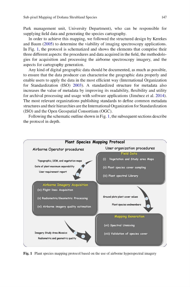
In Fig. 1, the protocol is schematized and shows the elements that comprise their
three different aspects: the procedures and data acquired in the field, the methodologies for acquisition and processing the airborne spectroscopy imagery, and the
aspects for cartography generation.
Any kind of digital geographic data should be documented, as much as possible,
to ensure that the data producer can characterise the geographic data properly and
enable users to apply the data in the most efficient way (International Organization
for Standardization (ISO) 2003). A standardized structure for metadata also
increases the value of metadata by improving its readability, flexibility and utility
for archival processing and usage with software applications (Jiménez et al. 2014).
The most relevant organizations publishing standards to define common metadata
structures and their hierarchies are the International Organization for Standardization
(ISO) and the Open Geospatial Consortium (OGC).
Following the schematic outline shown in Fig. 1, the subsequent sections describe
the protocol in depth.
Fig. 1 Plant species mapping protocol based on the use of airborne hyperspectral imagery
Sub-pixel Mapping of Doñana Shrubland Species
Park management unit, University Department), who can be responsible for
supplying field data and generating the species cartography.
In order to achieve this mapping, we followed the structured design by Kerekes
and Baum (2005) to determine the viability of imaging spectroscopy applications.
In Fig. 1, the protocol is schematized and shows the elements that comprise their
three different aspects: the procedures and data acquired in the field, the methodologies for acquisition and processing the airborne spectroscopy imagery, and the
aspects for cartography generation.
Any kind of digital geographic data should be documented, as much as possible,
to ensure that the data producer can characterise the geographic data properly and
enable users to apply the data in the most efficient way (International Organization
for Standardization (ISO) 2003). A standardized structure for metadata also
increases the value of metadata by improving its readability, flexibility and utility
for archival processing and usage with software applications (Jiménez et al. 2014).
The most relevant organizations publishing standards to define common metadata
structures and their hierarchies are the International Organization for Standardization
(ISO) and the Open Geospatial Consortium (OGC).
Following the schematic outline shown in Fig. 1, the subsequent sections describe
the protocol in depth.
Fig. 1 Plant species mapping protocol based on the use of airborne hyperspectral imagery
Sub-pixel Mapping of Doñana Shrubland Species