

98
Marian de Vries and Peter van Oosterom
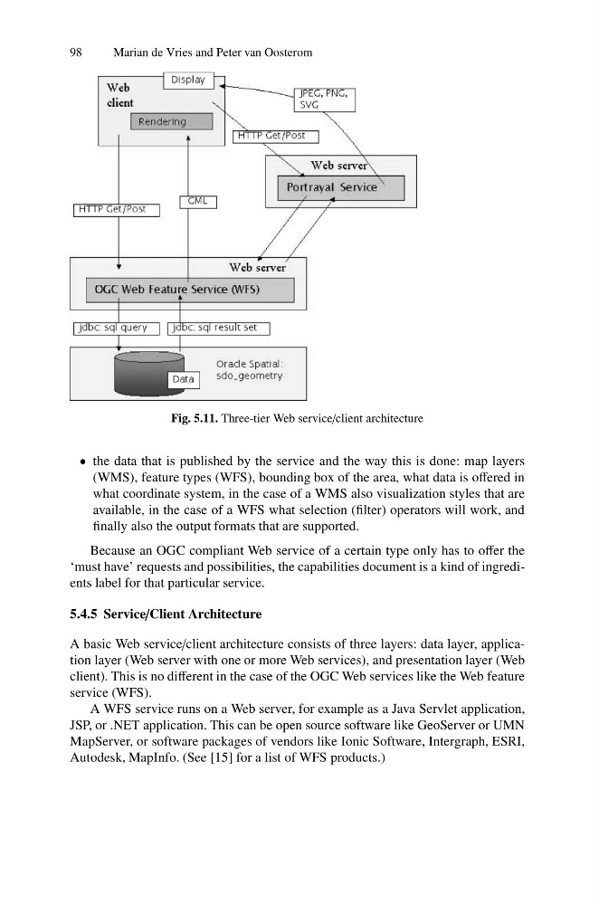
Fig. 5.11. Three-tier Web service/client architecture
• the data that is published by the service and the way this is done: map layers
(WMS), feature types (WFS), bounding box of the area, what data is offered in
what coordinate system, in the case of a WMS also visualization styles that are
available, in the case of a WFS what selection (filter) operators will work, and
finally also the output formats that are supported.
Because an OGC compliant Web service of a certain type only has to offer the
‘must have’ requests and possibilities, the capabilities document is a kind of ingredients label for that particular service.
5.4.5 Service/Client Architecture
A basic Web service/client architecture consists of three layers: data layer, application layer (Web server with one or more Web services), and presentation layer (Web
client). This is no different in the case of the OGC Web services like the Web feature
service (WFS).
A WFS service runs on a Web server, for example as a Java Servlet application,
JSP, or .NET application. This can be open source software like GeoServer or UMN
MapServer, or software packages of vendors like Ionic Software, Intergraph, ESRI,
Autodesk, MapInfo. (See [15] for a list of WFS products.)
Marian de Vries and Peter van Oosterom
Fig. 5.11. Three-tier Web service/client architecture
• the data that is published by the service and the way this is done: map layers
(WMS), feature types (WFS), bounding box of the area, what data is offered in
what coordinate system, in the case of a WMS also visualization styles that are
available, in the case of a WFS what selection (filter) operators will work, and
finally also the output formats that are supported.
Because an OGC compliant Web service of a certain type only has to offer the
‘must have’ requests and possibilities, the capabilities document is a kind of ingredients label for that particular service.
5.4.5 Service/Client Architecture
A basic Web service/client architecture consists of three layers: data layer, application layer (Web server with one or more Web services), and presentation layer (Web
client). This is no different in the case of the OGC Web services like the Web feature
service (WFS).
A WFS service runs on a Web server, for example as a Java Servlet application,
JSP, or .NET application. This can be open source software like GeoServer or UMN
MapServer, or software packages of vendors like Ionic Software, Intergraph, ESRI,
Autodesk, MapInfo. (See [15] for a list of WFS products.)