

72
Michela Bertolotto
Simplified
coastline
I sland
Road
Simplified
coastline
Simplified
road
(a)
(b)
(c)
Coastline
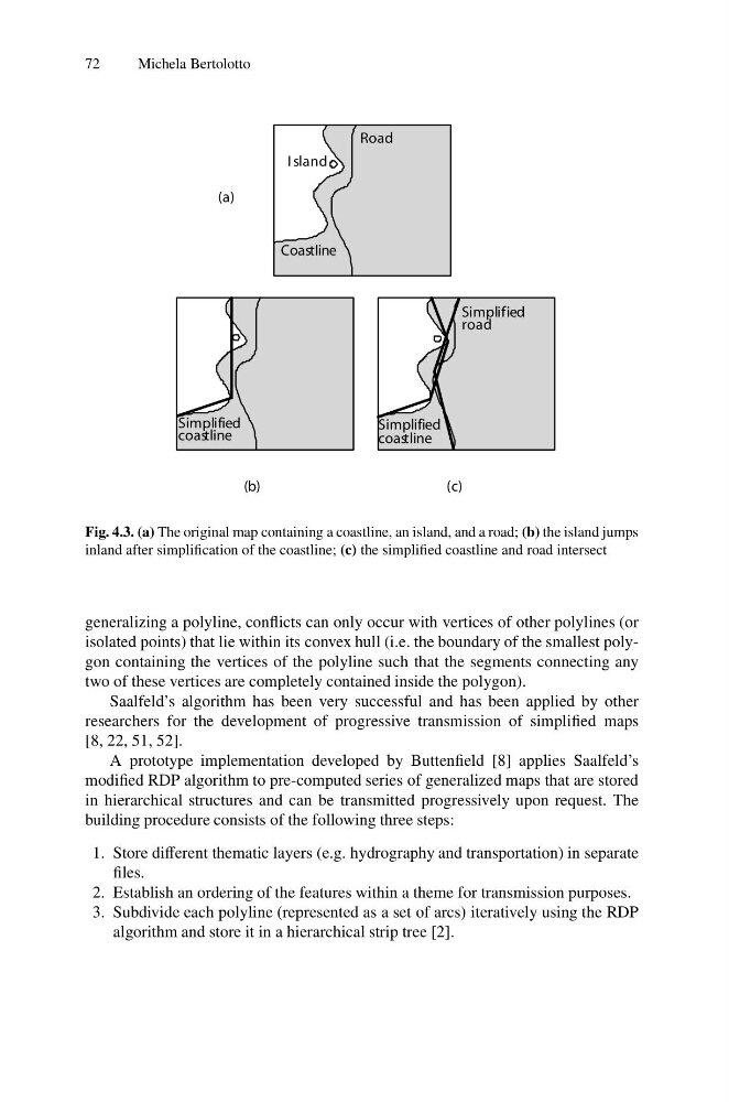
Fig. 4.3. (a) The original map containing a coastline, an island, and a road; (b) the island jumps
inland after simplification of the coastline; (c) the simplified coastline and road intersect
generalizing a polyline, conflicts can only occur with vertices of other polylines (or
isolated points) that lie within its convex hull (i.e. the boundary of the smallest polygon containing the vertices of the polyline such that the segments connecting any
two of these vertices are completely contained inside the polygon).
Saalfeld’s algorithm has been very successful and has been applied by other
researchers for the development of progressive transmission of simplified maps
[8, 22, 51, 52].
A prototype implementation developed by Buttenfield [8] applies Saalfeld’s
modified RDP algorithm to pre-computed series of generalized maps that are stored
in hierarchical structures and can be transmitted progressively upon request. The
building procedure consists of the following three steps:
1. Store different thematic layers (e.g. hydrography and transportation) in separate
files.
2. Establish an ordering of the features within a theme for transmission purposes.
3. Subdivide each polyline (represented as a set of arcs) iteratively using the RDP
algorithm and store it in a hierarchical strip tree [2].
Michela Bertolotto
Simplified
coastline
I sland
Road
Simplified
coastline
Simplified
road
(a)
(b)
(c)
Coastline
Fig. 4.3. (a) The original map containing a coastline, an island, and a road; (b) the island jumps
inland after simplification of the coastline; (c) the simplified coastline and road intersect
generalizing a polyline, conflicts can only occur with vertices of other polylines (or
isolated points) that lie within its convex hull (i.e. the boundary of the smallest polygon containing the vertices of the polyline such that the segments connecting any
two of these vertices are completely contained inside the polygon).
Saalfeld’s algorithm has been very successful and has been applied by other
researchers for the development of progressive transmission of simplified maps
[8, 22, 51, 52].
A prototype implementation developed by Buttenfield [8] applies Saalfeld’s
modified RDP algorithm to pre-computed series of generalized maps that are stored
in hierarchical structures and can be transmitted progressively upon request. The
building procedure consists of the following three steps:
1. Store different thematic layers (e.g. hydrography and transportation) in separate
files.
2. Establish an ordering of the features within a theme for transmission purposes.
3. Subdivide each polyline (represented as a set of arcs) iteratively using the RDP
algorithm and store it in a hierarchical strip tree [2].