

3 Out-of-core Multiresolution Terrain Modeling
53
010110
011100
011110
010100
011010
011000
011001
011011
010101
010111
011101
011111
010001
010000
010010
010011
100101
100111
100110
100100
101010
101000
101001
101011
101101
101111
101110
101100
100001
100010
100011
100000
110000
110010
110001
110011
111001
111010
111011
111000
110100
110110
110101
110111
111111
111110
111101
111100
000000
000001
000010
000011
001001
001010
001011
001000
001100
001110
001101
001111
000100
000110
000111
000101
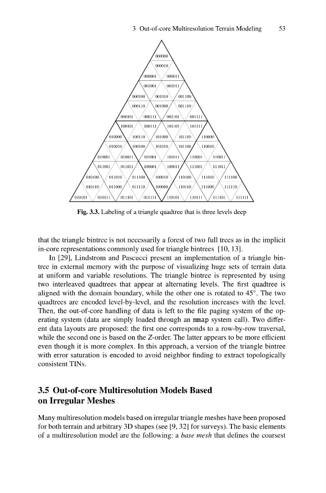
Fig. 3.3. Labeling of a triangle quadtree that is three levels deep
that the triangle bintree is not necessarily a forest of two full trees as in the implicit
in-core representations commonly used for triangle bintrees [10, 13].
In [29], Lindstrom and Pascucci present an implementation of a triangle bintree in external memory with the purpose of visualizing huge sets of terrain data
at uniform and variable resolutions. The triangle bintree is represented by using
two interleaved quadtrees that appear at alternating levels. The first quadtree is
aligned with the domain boundary, while the other one is rotated to 45
◦ . The two
quadtrees are encoded level-by-level, and the resolution increases with the level.
Then, the out-of-core handling of data is left to the file paging system of the operating system (data are simply loaded through an mmap system call). Two different data layouts are proposed: the first one corresponds to a row-by-row traversal,
while the second one is based on the Z-order. The latter appears to be more efficient
even though it is more complex. In this approach, a version of the triangle bintree
with error saturation is encoded to avoid neighbor finding to extract topologically
consistent TINs.
3.5 Out-of-core Multiresolution Models Based
on Irregular Meshes
Many multiresolution models based on irregular triangle meshes have been proposed
for both terrain and arbitrary 3D shapes (see [9, 32] for surveys). The basic elements
of a multiresolution model are the following: a base mesh that defines the coarsest
53
010110
011100
011110
010100
011010
011000
011001
011011
010101
010111
011101
011111
010001
010000
010010
010011
100101
100111
100110
100100
101010
101000
101001
101011
101101
101111
101110
101100
100001
100010
100011
100000
110000
110010
110001
110011
111001
111010
111011
111000
110100
110110
110101
110111
111111
111110
111101
111100
000000
000001
000010
000011
001001
001010
001011
001000
001100
001110
001101
001111
000100
000110
000111
000101
Fig. 3.3. Labeling of a triangle quadtree that is three levels deep
that the triangle bintree is not necessarily a forest of two full trees as in the implicit
in-core representations commonly used for triangle bintrees [10, 13].
In [29], Lindstrom and Pascucci present an implementation of a triangle bintree in external memory with the purpose of visualizing huge sets of terrain data
at uniform and variable resolutions. The triangle bintree is represented by using
two interleaved quadtrees that appear at alternating levels. The first quadtree is
aligned with the domain boundary, while the other one is rotated to 45
◦ . The two
quadtrees are encoded level-by-level, and the resolution increases with the level.
Then, the out-of-core handling of data is left to the file paging system of the operating system (data are simply loaded through an mmap system call). Two different data layouts are proposed: the first one corresponds to a row-by-row traversal,
while the second one is based on the Z-order. The latter appears to be more efficient
even though it is more complex. In this approach, a version of the triangle bintree
with error saturation is encoded to avoid neighbor finding to extract topologically
consistent TINs.
3.5 Out-of-core Multiresolution Models Based
on Irregular Meshes
Many multiresolution models based on irregular triangle meshes have been proposed
for both terrain and arbitrary 3D shapes (see [9, 32] for surveys). The basic elements
of a multiresolution model are the following: a base mesh that defines the coarsest