

12 Geographical Data Visualization on Mobile Devices
275
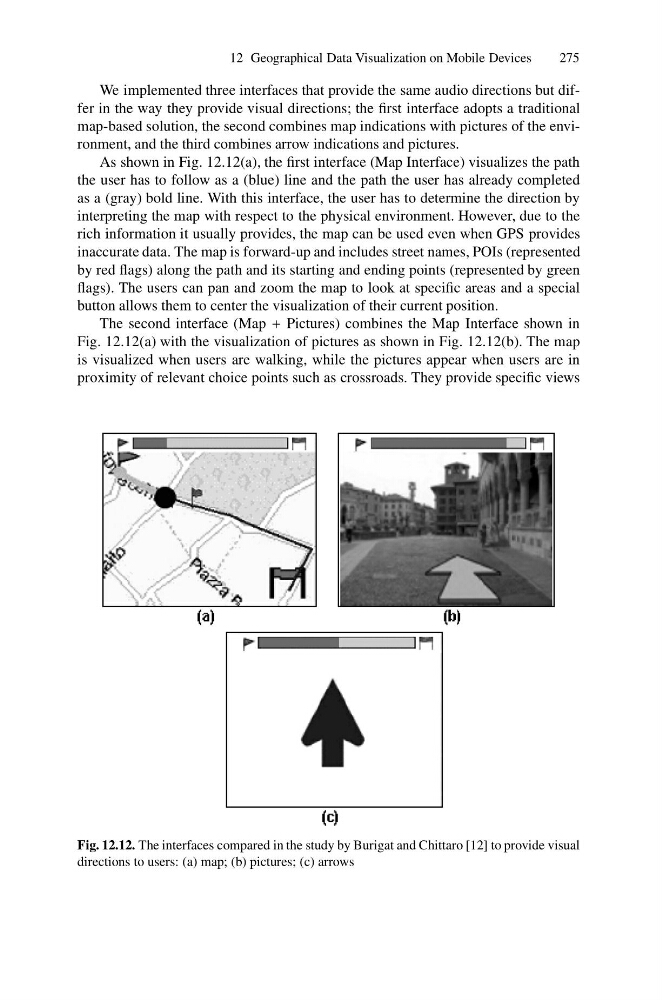
We implemented three interfaces that provide the same audio directions but differ in the way they provide visual directions; the first interface adopts a traditional
map-based solution, the second combines map indications with pictures of the environment, and the third combines arrow indications and pictures.
As shown in Fig. 12.12(a), the first interface (Map Interface) visualizes the path
the user has to follow as a (blue) line and the path the user has already completed
as a (gray) bold line. With this interface, the user has to determine the direction by
interpreting the map with respect to the physical environment. However, due to the
rich information it usually provides, the map can be used even when GPS provides
inaccurate data. The map is forward-up and includes street names, POIs (represented
by red flags) along the path and its starting and ending points (represented by green
flags). The users can pan and zoom the map to look at specific areas and a special
button allows them to center the visualization of their current position.
The second interface (Map + Pictures) combines the Map Interface shown in
Fig. 12.12(a) with the visualization of pictures as shown in Fig. 12.12(b). The map
is visualized when users are walking, while the pictures appear when users are in
proximity of relevant choice points such as crossroads. They provide specific views
Fig. 12.12. The interfaces compared in the study by Burigat and Chittaro [12] to provide visual
directions to users: (a) map; (b) pictures; (c) arrows
275
We implemented three interfaces that provide the same audio directions but differ in the way they provide visual directions; the first interface adopts a traditional
map-based solution, the second combines map indications with pictures of the environment, and the third combines arrow indications and pictures.
As shown in Fig. 12.12(a), the first interface (Map Interface) visualizes the path
the user has to follow as a (blue) line and the path the user has already completed
as a (gray) bold line. With this interface, the user has to determine the direction by
interpreting the map with respect to the physical environment. However, due to the
rich information it usually provides, the map can be used even when GPS provides
inaccurate data. The map is forward-up and includes street names, POIs (represented
by red flags) along the path and its starting and ending points (represented by green
flags). The users can pan and zoom the map to look at specific areas and a special
button allows them to center the visualization of their current position.
The second interface (Map + Pictures) combines the Map Interface shown in
Fig. 12.12(a) with the visualization of pictures as shown in Fig. 12.12(b). The map
is visualized when users are walking, while the pictures appear when users are in
proximity of relevant choice points such as crossroads. They provide specific views
Fig. 12.12. The interfaces compared in the study by Burigat and Chittaro [12] to provide visual
directions to users: (a) map; (b) pictures; (c) arrows