

12 Geographical Data Visualization on Mobile Devices
273
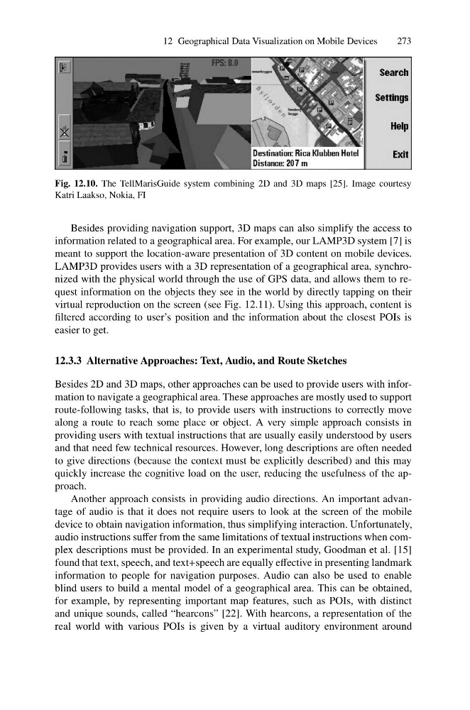
Fig. 12.10. The TellMarisGuide system combining 2D and 3D maps [25]. Image courtesy
Katri Laakso, Nokia, FI
Besides providing navigation support, 3D maps can also simplify the access to
information related to a geographical area. For example, our LAMP3D system [7] is
meant to support the location-aware presentation of 3D content on mobile devices.
LAMP3D provides users with a 3D representation of a geographical area, synchronized with the physical world through the use of GPS data, and allows them to request information on the objects they see in the world by directly tapping on their
virtual reproduction on the screen (see Fig. 12.11). Using this approach, content is
filtered according to user’s position and the information about the closest POIs is
easier to get.
12.3.3 Alternative Approaches: Text, Audio, and Route Sketches
Besides 2D and 3D maps, other approaches can be used to provide users with information to navigate a geographical area. These approaches are mostly used to support
route-following tasks, that is, to provide users with instructions to correctly move
along a route to reach some place or object. A very simple approach consists in
providing users with textual instructions that are usually easily understood by users
and that need few technical resources. However, long descriptions are often needed
to give directions (because the context must be explicitly described) and this may
quickly increase the cognitive load on the user, reducing the usefulness of the approach.
Another approach consists in providing audio directions. An important advantage of audio is that it does not require users to look at the screen of the mobile
device to obtain navigation information, thus simplifying interaction. Unfortunately,
audio instructions suffer from the same limitations of textual instructions when complex descriptions must be provided. In an experimental study, Goodman et al. [15]
found that text, speech, and text+speech are equally effective in presenting landmark
information to people for navigation purposes. Audio can also be used to enable
blind users to build a mental model of a geographical area. This can be obtained,
for example, by representing important map features, such as POIs, with distinct
and unique sounds, called “hearcons” [22]. With hearcons, a representation of the
real world with various POIs is given by a virtual auditory environment around
273
Fig. 12.10. The TellMarisGuide system combining 2D and 3D maps [25]. Image courtesy
Katri Laakso, Nokia, FI
Besides providing navigation support, 3D maps can also simplify the access to
information related to a geographical area. For example, our LAMP3D system [7] is
meant to support the location-aware presentation of 3D content on mobile devices.
LAMP3D provides users with a 3D representation of a geographical area, synchronized with the physical world through the use of GPS data, and allows them to request information on the objects they see in the world by directly tapping on their
virtual reproduction on the screen (see Fig. 12.11). Using this approach, content is
filtered according to user’s position and the information about the closest POIs is
easier to get.
12.3.3 Alternative Approaches: Text, Audio, and Route Sketches
Besides 2D and 3D maps, other approaches can be used to provide users with information to navigate a geographical area. These approaches are mostly used to support
route-following tasks, that is, to provide users with instructions to correctly move
along a route to reach some place or object. A very simple approach consists in
providing users with textual instructions that are usually easily understood by users
and that need few technical resources. However, long descriptions are often needed
to give directions (because the context must be explicitly described) and this may
quickly increase the cognitive load on the user, reducing the usefulness of the approach.
Another approach consists in providing audio directions. An important advantage of audio is that it does not require users to look at the screen of the mobile
device to obtain navigation information, thus simplifying interaction. Unfortunately,
audio instructions suffer from the same limitations of textual instructions when complex descriptions must be provided. In an experimental study, Goodman et al. [15]
found that text, speech, and text+speech are equally effective in presenting landmark
information to people for navigation purposes. Audio can also be used to enable
blind users to build a mental model of a geographical area. This can be obtained,
for example, by representing important map features, such as POIs, with distinct
and unique sounds, called “hearcons” [22]. With hearcons, a representation of the
real world with various POIs is given by a virtual auditory environment around