

12 Geographical Data Visualization on Mobile Devices
267
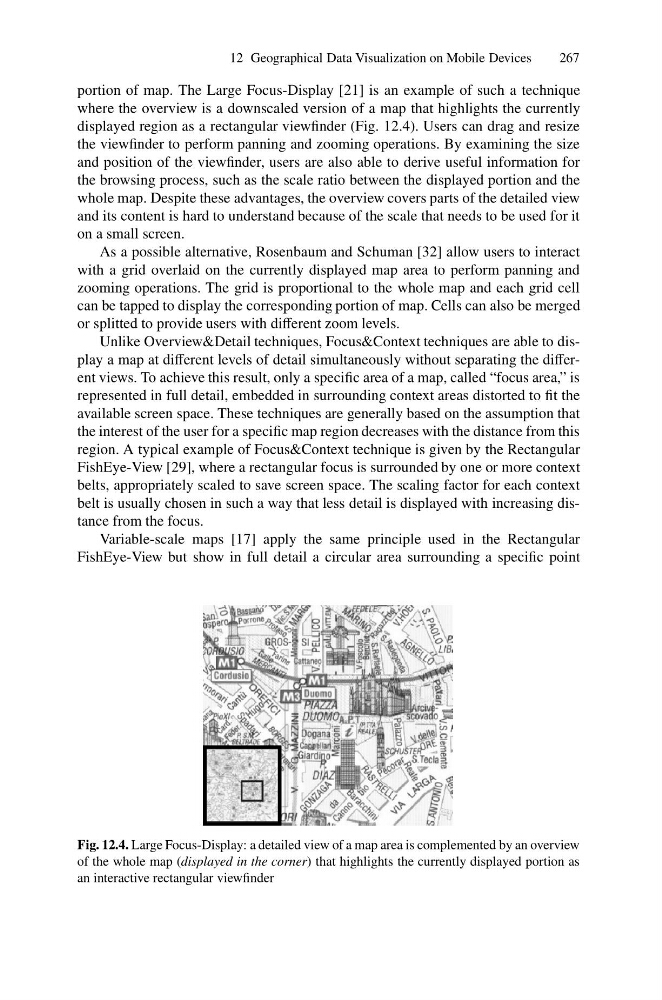
portion of map. The Large Focus-Display [21] is an example of such a technique
where the overview is a downscaled version of a map that highlights the currently
displayed region as a rectangular viewfinder (Fig. 12.4). Users can drag and resize
the viewfinder to perform panning and zooming operations. By examining the size
and position of the viewfinder, users are also able to derive useful information for
the browsing process, such as the scale ratio between the displayed portion and the
whole map. Despite these advantages, the overview covers parts of the detailed view
and its content is hard to understand because of the scale that needs to be used for it
on a small screen.
As a possible alternative, Rosenbaum and Schuman [32] allow users to interact
with a grid overlaid on the currently displayed map area to perform panning and
zooming operations. The grid is proportional to the whole map and each grid cell
can be tapped to display the corresponding portion of map. Cells can also be merged
or splitted to provide users with different zoom levels.
Unlike Overview&Detail techniques, Focus&Context techniques are able to display a map at different levels of detail simultaneously without separating the different views. To achieve this result, only a specific area of a map, called “focus area,” is
represented in full detail, embedded in surrounding context areas distorted to fit the
available screen space. These techniques are generally based on the assumption that
the interest of the user for a specific map region decreases with the distance from this
region. A typical example of Focus&Context technique is given by the Rectangular
FishEye-View [29], where a rectangular focus is surrounded by one or more context
belts, appropriately scaled to save screen space. The scaling factor for each context
belt is usually chosen in such a way that less detail is displayed with increasing distance from the focus.
Variable-scale maps [17] apply the same principle used in the Rectangular
FishEye-View but show in full detail a circular area surrounding a specific point
Fig. 12.4. Large Focus-Display: a detailed view of a map area is complemented by an overview
of the whole map (displayed in the corner) that highlights the currently displayed portion as
an interactive rectangular viewfinder
267
portion of map. The Large Focus-Display [21] is an example of such a technique
where the overview is a downscaled version of a map that highlights the currently
displayed region as a rectangular viewfinder (Fig. 12.4). Users can drag and resize
the viewfinder to perform panning and zooming operations. By examining the size
and position of the viewfinder, users are also able to derive useful information for
the browsing process, such as the scale ratio between the displayed portion and the
whole map. Despite these advantages, the overview covers parts of the detailed view
and its content is hard to understand because of the scale that needs to be used for it
on a small screen.
As a possible alternative, Rosenbaum and Schuman [32] allow users to interact
with a grid overlaid on the currently displayed map area to perform panning and
zooming operations. The grid is proportional to the whole map and each grid cell
can be tapped to display the corresponding portion of map. Cells can also be merged
or splitted to provide users with different zoom levels.
Unlike Overview&Detail techniques, Focus&Context techniques are able to display a map at different levels of detail simultaneously without separating the different views. To achieve this result, only a specific area of a map, called “focus area,” is
represented in full detail, embedded in surrounding context areas distorted to fit the
available screen space. These techniques are generally based on the assumption that
the interest of the user for a specific map region decreases with the distance from this
region. A typical example of Focus&Context technique is given by the Rectangular
FishEye-View [29], where a rectangular focus is surrounded by one or more context
belts, appropriately scaled to save screen space. The scaling factor for each context
belt is usually chosen in such a way that less detail is displayed with increasing distance from the focus.
Variable-scale maps [17] apply the same principle used in the Rectangular
FishEye-View but show in full detail a circular area surrounding a specific point
Fig. 12.4. Large Focus-Display: a detailed view of a map area is complemented by an overview
of the whole map (displayed in the corner) that highlights the currently displayed portion as
an interactive rectangular viewfinder