

236
Maria Calagna and Luigi V. Mancini
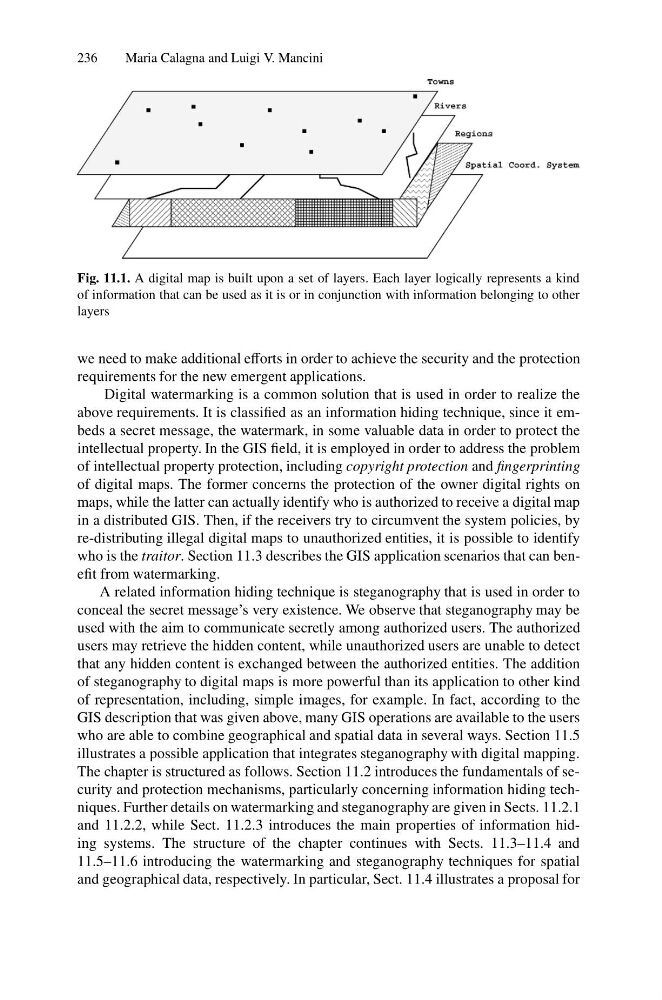
Fig. 11.1. A digital map is built upon a set of layers. Each layer logically represents a kind
of information that can be used as it is or in conjunction with information belonging to other
layers
we need to make additional efforts in order to achieve the security and the protection
requirements for the new emergent applications.
Digital watermarking is a common solution that is used in order to realize the
above requirements. It is classified as an information hiding technique, since it embeds a secret message, the watermark, in some valuable data in order to protect the
intellectual property. In the GIS field, it is employed in order to address the problem
of intellectual property protection, including copyright protection and fingerprinting
of digital maps. The former concerns the protection of the owner digital rights on
maps, while the latter can actually identify who is authorized to receive a digital map
in a distributed GIS. Then, if the receivers try to circumvent the system policies, by
re-distributing illegal digital maps to unauthorized entities, it is possible to identify
who is the traitor. Section 11.3 describes the GIS application scenarios that can benefit from watermarking.
A related information hiding technique is steganography that is used in order to
conceal the secret message’s very existence. We observe that steganography may be
used with the aim to communicate secretly among authorized users. The authorized
users may retrieve the hidden content, while unauthorized users are unable to detect
that any hidden content is exchanged between the authorized entities. The addition
of steganography to digital maps is more powerful than its application to other kind
of representation, including, simple images, for example. In fact, according to the
GIS description that was given above, many GIS operations are available to the users
who are able to combine geographical and spatial data in several ways. Section 11.5
illustrates a possible application that integrates steganography with digital mapping.
The chapter is structured as follows. Section 11.2 introduces the fundamentals of security and protection mechanisms, particularly concerning information hiding techniques. Further details on watermarking and steganography are given in Sects. 11.2.1
and 11.2.2, while Sect. 11.2.3 introduces the main properties of information hiding systems. The structure of the chapter continues with Sects. 11.3–11.4 and
11.5–11.6 introducing the watermarking and steganography techniques for spatial
and geographical data, respectively. In particular, Sect. 11.4 illustrates a proposal for
Maria Calagna and Luigi V. Mancini
Fig. 11.1. A digital map is built upon a set of layers. Each layer logically represents a kind
of information that can be used as it is or in conjunction with information belonging to other
layers
we need to make additional efforts in order to achieve the security and the protection
requirements for the new emergent applications.
Digital watermarking is a common solution that is used in order to realize the
above requirements. It is classified as an information hiding technique, since it embeds a secret message, the watermark, in some valuable data in order to protect the
intellectual property. In the GIS field, it is employed in order to address the problem
of intellectual property protection, including copyright protection and fingerprinting
of digital maps. The former concerns the protection of the owner digital rights on
maps, while the latter can actually identify who is authorized to receive a digital map
in a distributed GIS. Then, if the receivers try to circumvent the system policies, by
re-distributing illegal digital maps to unauthorized entities, it is possible to identify
who is the traitor. Section 11.3 describes the GIS application scenarios that can benefit from watermarking.
A related information hiding technique is steganography that is used in order to
conceal the secret message’s very existence. We observe that steganography may be
used with the aim to communicate secretly among authorized users. The authorized
users may retrieve the hidden content, while unauthorized users are unable to detect
that any hidden content is exchanged between the authorized entities. The addition
of steganography to digital maps is more powerful than its application to other kind
of representation, including, simple images, for example. In fact, according to the
GIS description that was given above, many GIS operations are available to the users
who are able to combine geographical and spatial data in several ways. Section 11.5
illustrates a possible application that integrates steganography with digital mapping.
The chapter is structured as follows. Section 11.2 introduces the fundamentals of security and protection mechanisms, particularly concerning information hiding techniques. Further details on watermarking and steganography are given in Sects. 11.2.1
and 11.2.2, while Sect. 11.2.3 introduces the main properties of information hiding systems. The structure of the chapter continues with Sects. 11.3–11.4 and
11.5–11.6 introducing the watermarking and steganography techniques for spatial
and geographical data, respectively. In particular, Sect. 11.4 illustrates a proposal for