

24
Carlo Combi, Sara Migliorini, Barbara Oliboni, and Alberto Belussi
In a GeoMTGM database, several field-based geographical properties can be
stored, so we need to identify each of them in a unique way. For this purpose, we
introduce a special complex node named “GeoField” node that represents a particular
geographical property and has an atomic node named “GeoFieldName,” representing
its unique name with respect to the considered GeoMTGM graph.
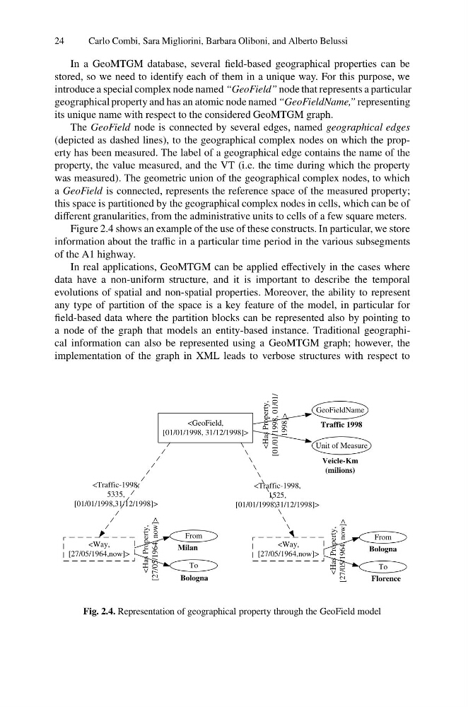
The GeoField node is connected by several edges, named geographical edges
(depicted as dashed lines), to the geographical complex nodes on which the property has been measured. The label of a geographical edge contains the name of the
property, the value measured, and the VT (i.e. the time during which the property
was measured). The geometric union of the geographical complex nodes, to which
a GeoField is connected, represents the reference space of the measured property;
this space is partitioned by the geographical complex nodes in cells, which can be of
different granularities, from the administrative units to cells of a few square meters.
Figure 2.4 shows an example of the use of these constructs. In particular, we store
information about the traffic in a particular time period in the various subsegments
of the A1 highway.
In real applications, GeoMTGM can be applied effectively in the cases where
data have a non-uniform structure, and it is important to describe the temporal
evolutions of spatial and non-spatial properties. Moreover, the ability to represent
any type of partition of the space is a key feature of the model, in particular for
field-based data where the partition blocks can be represented also by pointing to
a node of the graph that models an entity-based instance. Traditional geographical information can also be represented using a GeoMTGM graph; however, the
implementation of the graph in XML leads to verbose structures with respect to
GeoFieldName
From
To
Unit of Measure
Traffic 1998
Veicle-Km
(milions)
Milan
To
Bologna
Bologna
Florence
1998]>
From
[01/01/1998,31/12/1998]>
[01/01/1998,31/12/1998]>
Fig. 2.4. Representation of geographical property through the GeoField model
Carlo Combi, Sara Migliorini, Barbara Oliboni, and Alberto Belussi
In a GeoMTGM database, several field-based geographical properties can be
stored, so we need to identify each of them in a unique way. For this purpose, we
introduce a special complex node named “GeoField” node that represents a particular
geographical property and has an atomic node named “GeoFieldName,” representing
its unique name with respect to the considered GeoMTGM graph.
The GeoField node is connected by several edges, named geographical edges
(depicted as dashed lines), to the geographical complex nodes on which the property has been measured. The label of a geographical edge contains the name of the
property, the value measured, and the VT (i.e. the time during which the property
was measured). The geometric union of the geographical complex nodes, to which
a GeoField is connected, represents the reference space of the measured property;
this space is partitioned by the geographical complex nodes in cells, which can be of
different granularities, from the administrative units to cells of a few square meters.
Figure 2.4 shows an example of the use of these constructs. In particular, we store
information about the traffic in a particular time period in the various subsegments
of the A1 highway.
In real applications, GeoMTGM can be applied effectively in the cases where
data have a non-uniform structure, and it is important to describe the temporal
evolutions of spatial and non-spatial properties. Moreover, the ability to represent
any type of partition of the space is a key feature of the model, in particular for
field-based data where the partition blocks can be represented also by pointing to
a node of the graph that models an entity-based instance. Traditional geographical information can also be represented using a GeoMTGM graph; however, the
implementation of the graph in XML leads to verbose structures with respect to
GeoFieldName
From
To
Unit of Measure
Traffic 1998
Veicle-Km
(milions)
Milan
To
Bologna
Bologna
Florence
1998]>
From
[01/01/1998,31/12/1998]>
[01/01/1998,31/12/1998]>
Fig. 2.4. Representation of geographical property through the GeoField model