

22
Carlo Combi, Sara Migliorini, Barbara Oliboni, and Alberto Belussi
[11/02/2006,
12/02/2006]>
03/01/2006]>
Gravity
Tail
From
To
Closed
Tail
Where
Traffic
Telepass
Via Card
Operator
Piacenza sud
Parma
Yes
4 km
12/02/2006]>
Piacenza sud
trafic-2006-02-11.mpg
3
1
5
<
H
a
s
M
M
P
r
o
p
e
r
t
y
,
[
1
1
/
0
2
/
2
0
0
6
,
1
1
/
0
2
/
2
0
0
6
]
,
[
0
,i
n
f
i
n
i
t
y
]
>
From
To
Milan
Parma
One lane closed
1 km
03/01/2006]>
Line
<[x1,y1],[x2,y2]>
Point
Line
<[x'1,y'1],[x'2,y'2]>
12/02/2006]>
Point
Traffic
trafic-2006-02-17.mpg
< H a s M M P r o p e r ty ,
[ 1 7 /0 2 /2 0 0 6 , 1 7 /0 2 /2 0 0 6 ] ,
[ 0 ,i n f in it y ] >
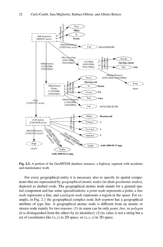
Fig. 2.3. A portion of the GeoMTGM database instance: a highway segment with accidents
and maintenance work
For every geographical entity it is necessary also to specify its spatial components that are represented by geographical atomic nodes (in short geoAtomic nodes),
depicted as dashed ovals. The geographical atomic node stands for a general spatial component and has some specializations: a point node represents a point, a line
node represents a line, and a polygon node represents a region in the space. For example, in Fig. 2.1 the geographical complex node Sub-segment has a geographical
attribute of type line. A geographical atomic node is different from an atomic or
stream node mainly for two reasons: (1) its name can be only point, line, or polygon
(it is distinguished from the others by its identifier); (2) its value is not a string but a
set of coordinates like (x, y) in 2D space, or (x, y, z) in 3D space.
Carlo Combi, Sara Migliorini, Barbara Oliboni, and Alberto Belussi
[11/02/2006,
12/02/2006]>
03/01/2006]>
Gravity
Tail
From
To
Closed
Tail
Where
Traffic
Telepass
Via Card
Operator
Piacenza sud
Parma
Yes
4 km
12/02/2006]>
Piacenza sud
trafic-2006-02-11.mpg
3
1
5
<
H
a
s
M
M
P
r
o
p
e
r
t
y
,
[
1
1
/
0
2
/
2
0
0
6
,
1
1
/
0
2
/
2
0
0
6
]
,
[
0
,i
n
f
i
n
i
t
y
]
>
From
To
Milan
Parma
One lane closed
1 km
03/01/2006]>
Line
<[x1,y1],[x2,y2]>
Point
Line
<[x'1,y'1],[x'2,y'2]>
12/02/2006]>
Point
Traffic
trafic-2006-02-17.mpg
< H a s M M P r o p e r ty ,
[ 1 7 /0 2 /2 0 0 6 , 1 7 /0 2 /2 0 0 6 ] ,
[ 0 ,i n f in it y ] >
Fig. 2.3. A portion of the GeoMTGM database instance: a highway segment with accidents
and maintenance work
For every geographical entity it is necessary also to specify its spatial components that are represented by geographical atomic nodes (in short geoAtomic nodes),
depicted as dashed ovals. The geographical atomic node stands for a general spatial component and has some specializations: a point node represents a point, a line
node represents a line, and a polygon node represents a region in the space. For example, in Fig. 2.1 the geographical complex node Sub-segment has a geographical
attribute of type line. A geographical atomic node is different from an atomic or
stream node mainly for two reasons: (1) its name can be only point, line, or polygon
(it is distinguished from the others by its identifier); (2) its value is not a string but a
set of coordinates like (x, y) in 2D space, or (x, y, z) in 3D space.