

8 Using Qualitative Information in Query Proc. over Multiresolution Maps
167
8.3.1 The Reference Spatial Data Model
We define a map schema as a set of feature types, object classes representing
real-world entities (e.g. lakes, rivers, etc.). Each feature type has some descriptive
attributes, including a feature identifier and a spatial attribute, having a given
dimension. We assume that values for the spatial attribute are modeled according
to the OGC simple feature geometric model [14], restricted to consider only connected objects. In such a model, the geometry of an object can be of type point (dimension 0, also denoted by P), line (dimension 1, also denoted by L), or polygon –
more generally called region (dimension 2, also denoted by R). A point describes a
single location in the coordinate space; a line represents a linear interpolation of an
ordered sequence of points; a polygon is defined as an ordered sequence of closed
lines defining the exterior and interior boundaries (holes) of an area. In the following, we denote with REG, LINE, and POINT the set of all the connected regions
(possibly with holes), lines, and points in R
2 , respectively. We denote with OBJ the
set REG ∪ LINE ∪ POINT .
Given a set of map schemas MS 1 , ..., MS n and a set of feature types f t 1 , ..., f t m ,
we assume that a feature type may belong to one or more map schemas, possibly with
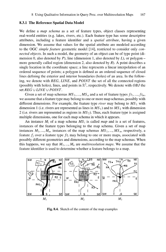
different dimensions. For example, the feature type river may belong to MS 1 with
dimension 1 (i.e. rivers are represented as lines in MS 1 ) and to MS 2 with dimension
2 (i.e. rivers are represented as regions in MS 2 ). Thus, each feature type is assigned
multiple dimensions, one for each map schema in which it appears.
An instance M i of a map schema MS i is called map and is a set of features,
instances of the feature types belonging to the map schema. Given a set of map
instances M 1 , ..., M n , instances of the map schemas MS 1 , ..., MS n , respectively, a
feature f j over a feature type f t i may belong to one or more maps, associated with
possibly different geometries and dimensions, according to the map schemas. When
this happens, we say that M 1 , ..., M n are multiresolution maps. We assume that the
feature identifier is used to determine whether a feature belongs to a map.
M 1
M 2
M 3
Fig. 8.4. Sketch of the content of the map examples
167
8.3.1 The Reference Spatial Data Model
We define a map schema as a set of feature types, object classes representing
real-world entities (e.g. lakes, rivers, etc.). Each feature type has some descriptive
attributes, including a feature identifier and a spatial attribute, having a given
dimension. We assume that values for the spatial attribute are modeled according
to the OGC simple feature geometric model [14], restricted to consider only connected objects. In such a model, the geometry of an object can be of type point (dimension 0, also denoted by P), line (dimension 1, also denoted by L), or polygon –
more generally called region (dimension 2, also denoted by R). A point describes a
single location in the coordinate space; a line represents a linear interpolation of an
ordered sequence of points; a polygon is defined as an ordered sequence of closed
lines defining the exterior and interior boundaries (holes) of an area. In the following, we denote with REG, LINE, and POINT the set of all the connected regions
(possibly with holes), lines, and points in R
2 , respectively. We denote with OBJ the
set REG ∪ LINE ∪ POINT .
Given a set of map schemas MS 1 , ..., MS n and a set of feature types f t 1 , ..., f t m ,
we assume that a feature type may belong to one or more map schemas, possibly with
different dimensions. For example, the feature type river may belong to MS 1 with
dimension 1 (i.e. rivers are represented as lines in MS 1 ) and to MS 2 with dimension
2 (i.e. rivers are represented as regions in MS 2 ). Thus, each feature type is assigned
multiple dimensions, one for each map schema in which it appears.
An instance M i of a map schema MS i is called map and is a set of features,
instances of the feature types belonging to the map schema. Given a set of map
instances M 1 , ..., M n , instances of the map schemas MS 1 , ..., MS n , respectively, a
feature f j over a feature type f t i may belong to one or more maps, associated with
possibly different geometries and dimensions, according to the map schemas. When
this happens, we say that M 1 , ..., M n are multiresolution maps. We assume that the
feature identifier is used to determine whether a feature belongs to a map.
M 1
M 2
M 3
Fig. 8.4. Sketch of the content of the map examples