

7 A Quality-enabled Spatial Integration System
139
NTDB-21e05 BDTQ-21ee201
Road
Road
roadL
vCommL
id
=
gid
Sescription
Street
Description =
entityname > Description
Highway
NbLanes
nbLanes
...
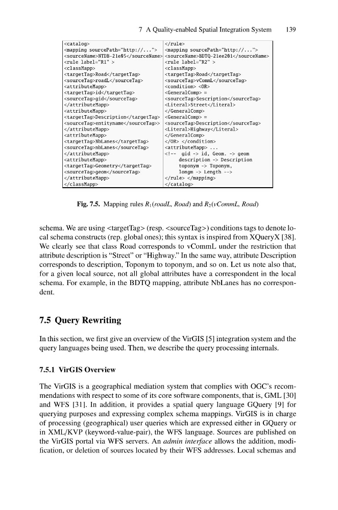
Fig. 7.5. Mapping rules R 1 (roadL, Road) and R 2 (vCommL, Road)
schema. We are using (resp. ) conditions tags to denote local schema constructs (rep. global ones); this syntax is inspired from XQueryX [38].
We clearly see that class Road corresponds to vCommL under the restriction that
attribute description is “Street” or “Highway.” In the same way, attribute Description
corresponds to description, Toponym to toponym, and so on. Let us note also that,
for a given local source, not all global attributes have a correspondent in the local
schema. For example, in the BDTQ mapping, attribute NbLanes has no correspondent.
7.5 Query Rewriting
In this section, we first give an overview of the VirGIS [5] integration system and the
query languages being used. Then, we describe the query processing internals.
7.5.1 VirGIS Overview
The VirGIS is a geographical mediation system that complies with OGC’s recommendations with respect to some of its core software components, that is, GML [30]
and WFS [31]. In addition, it provides a spatial query language GQuery [9] for
querying purposes and expressing complex schema mappings. VirGIS is in charge
of processing (geographical) user queries which are expressed either in GQuery or
in XML/KVP (keyword-value-pair), the WFS language. Sources are published on
the VirGIS portal via WFS servers. An admin interface allows the addition, modification, or deletion of sources located by their WFS addresses. Local schemas and
139
Fig. 7.5. Mapping rules R 1 (roadL, Road) and R 2 (vCommL, Road)
schema. We are using
We clearly see that class Road corresponds to vCommL under the restriction that
attribute description is “Street” or “Highway.” In the same way, attribute Description
corresponds to description, Toponym to toponym, and so on. Let us note also that,
for a given local source, not all global attributes have a correspondent in the local
schema. For example, in the BDTQ mapping, attribute NbLanes has no correspondent.
7.5 Query Rewriting
In this section, we first give an overview of the VirGIS [5] integration system and the
query languages being used. Then, we describe the query processing internals.
7.5.1 VirGIS Overview
The VirGIS is a geographical mediation system that complies with OGC’s recommendations with respect to some of its core software components, that is, GML [30]
and WFS [31]. In addition, it provides a spatial query language GQuery [9] for
querying purposes and expressing complex schema mappings. VirGIS is in charge
of processing (geographical) user queries which are expressed either in GQuery or
in XML/KVP (keyword-value-pair), the WFS language. Sources are published on
the VirGIS portal via WFS servers. An admin interface allows the addition, modification, or deletion of sources located by their WFS addresses. Local schemas and