

3 Thermal Infrared Remote Sensing and Sea Surface Temperature . . .
59
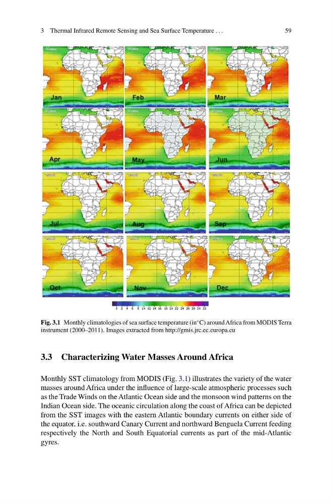
Fig. 3.1 Monthly climatologies of sea surface temperature (in
◦ C) around Africa from MODIS Terra
instrument (2000–2011). Images extracted from http://gmis.jrc.ec.europa.eu
3.3 Characterizing Water Masses Around Africa
Monthly SST climatology from MODIS (Fig. 3.1) illustrates the variety of the water
masses around Africa under the influence of large-scale atmospheric processes such
as the Trade Winds on the Atlantic Ocean side and the monsoon wind patterns on the
Indian Ocean side. The oceanic circulation along the coast of Africa can be depicted
from the SST images with the eastern Atlantic boundary currents on either side of
the equator, i.e. southward Canary Current and northward Benguela Current feeding
respectively the North and South Equatorial currents as part of the mid-Atlantic
gyres.
59
Fig. 3.1 Monthly climatologies of sea surface temperature (in
◦ C) around Africa from MODIS Terra
instrument (2000–2011). Images extracted from http://gmis.jrc.ec.europa.eu
3.3 Characterizing Water Masses Around Africa
Monthly SST climatology from MODIS (Fig. 3.1) illustrates the variety of the water
masses around Africa under the influence of large-scale atmospheric processes such
as the Trade Winds on the Atlantic Ocean side and the monsoon wind patterns on the
Indian Ocean side. The oceanic circulation along the coast of Africa can be depicted
from the SST images with the eastern Atlantic boundary currents on either side of
the equator, i.e. southward Canary Current and northward Benguela Current feeding
respectively the North and South Equatorial currents as part of the mid-Atlantic
gyres.