

380
M. Ahmed and V. Barale
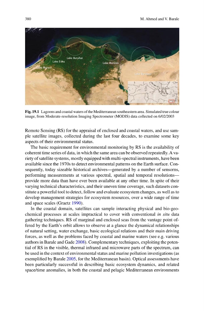
Fig. 19.1 Lagoons and coastal waters of the Mediterranean southeastern area. Simulated true colour
image, from Moderate-resolution Imaging Spectrometer (MODIS) data collected on 6/02/2003
Remote Sensing (RS) for the appraisal of enclosed and coastal waters, and use sample satellite images, collected during the last four decades, to examine some key
aspects of their environmental status.
The basic requirement for environmental monitoring by RS is the availability of
coherent time series of data, in which the same area can be observed repeatedly. A variety of satellite systems, mostly equipped with multi-spectral instruments, have been
available since the 1970s to detect environmental patterns on the Earth surface. Consequently, today sizeable historical archives—generated by a number of sensorns,
performing measurements at various spectral, spatial and temporal resolutions—
provide more data than have ever been available at any other time. In spite of their
varying technical characteristics, and their uneven time coverage, such datasets constitute a powerful tool to detect, follow and evaluate ecosystem changes, as well as to
develop management strategies for ecosystem resources, over a wide range of time
and space scales (Graetz 1990).
In the coastal domain, satellites can sample interacting physical and bio-geochemical processes at scales impractical to cover with conventional in situ data
gathering techniques. RS of marginal and enclosed seas from the vantage point offered by the Earth’s orbit allows to observe at a glance the dynamical relationships
of natural setting, water exchange, basic ecological relations and their main driving
forces, as well as the problems faced by coastal and marine waters (see e.g. various
authors in Barale and Gade 2008). Complementary techniques, exploiting the potential of RS in the visible, thermal infrared and microwave parts of the spectrum, can
be used in the context of environmental status and marine pollution investigations (as
exemplified by Barale 2005, for the Mediterranean basin). Optical assessments have
been particularly successful in describing basic ecosystem dynamics, and related
space/time anomalies, in both the coastal and pelagic Mediterranean environments
M. Ahmed and V. Barale
Fig. 19.1 Lagoons and coastal waters of the Mediterranean southeastern area. Simulated true colour
image, from Moderate-resolution Imaging Spectrometer (MODIS) data collected on 6/02/2003
Remote Sensing (RS) for the appraisal of enclosed and coastal waters, and use sample satellite images, collected during the last four decades, to examine some key
aspects of their environmental status.
The basic requirement for environmental monitoring by RS is the availability of
coherent time series of data, in which the same area can be observed repeatedly. A variety of satellite systems, mostly equipped with multi-spectral instruments, have been
available since the 1970s to detect environmental patterns on the Earth surface. Consequently, today sizeable historical archives—generated by a number of sensorns,
performing measurements at various spectral, spatial and temporal resolutions—
provide more data than have ever been available at any other time. In spite of their
varying technical characteristics, and their uneven time coverage, such datasets constitute a powerful tool to detect, follow and evaluate ecosystem changes, as well as to
develop management strategies for ecosystem resources, over a wide range of time
and space scales (Graetz 1990).
In the coastal domain, satellites can sample interacting physical and bio-geochemical processes at scales impractical to cover with conventional in situ data
gathering techniques. RS of marginal and enclosed seas from the vantage point offered by the Earth’s orbit allows to observe at a glance the dynamical relationships
of natural setting, water exchange, basic ecological relations and their main driving
forces, as well as the problems faced by coastal and marine waters (see e.g. various
authors in Barale and Gade 2008). Complementary techniques, exploiting the potential of RS in the visible, thermal infrared and microwave parts of the spectrum, can
be used in the context of environmental status and marine pollution investigations (as
exemplified by Barale 2005, for the Mediterranean basin). Optical assessments have
been particularly successful in describing basic ecosystem dynamics, and related
space/time anomalies, in both the coastal and pelagic Mediterranean environments