

14
V. Barale
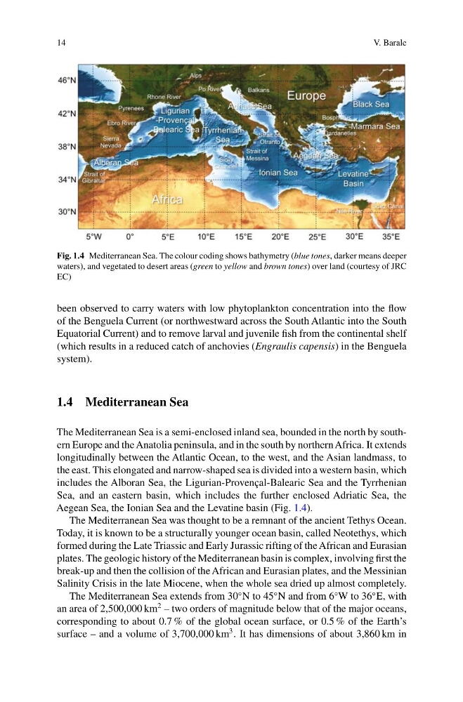
Fig. 1.4 Mediterranean Sea. The colour coding shows bathymetry (blue tones, darker means deeper
waters), and vegetated to desert areas (green to yellow and brown tones) over land (courtesy of JRC
EC)
been observed to carry waters with low phytoplankton concentration into the flow
of the Benguela Current (or northwestward across the South Atlantic into the South
Equatorial Current) and to remove larval and juvenile fish from the continental shelf
(which results in a reduced catch of anchovies (Engraulis capensis) in the Benguela
system).
1.4 Mediterranean Sea
The Mediterranean Sea is a semi-enclosed inland sea, bounded in the north by southern Europe and the Anatolia peninsula, and in the south by northern Africa. It extends
longitudinally between the Atlantic Ocean, to the west, and the Asian landmass, to
the east. This elongated and narrow-shaped sea is divided into a western basin, which
includes the Alboran Sea, the Ligurian-Provençal-Balearic Sea and the Tyrrhenian
Sea, and an eastern basin, which includes the further enclosed Adriatic Sea, the
Aegean Sea, the Ionian Sea and the Levatine basin (Fig. 1.4).
The Mediterranean Sea was thought to be a remnant of the ancient Tethys Ocean.
Today, it is known to be a structurally younger ocean basin, called Neotethys, which
formed during the Late Triassic and Early Jurassic rifting of the African and Eurasian
plates. The geologic history of the Mediterranean basin is complex, involving first the
break-up and then the collision of the African and Eurasian plates, and the Messinian
Salinity Crisis in the late Miocene, when the whole sea dried up almost completely.
The Mediterranean Sea extends from 30
◦ N to 45
◦ N and from 6
◦ W to 36
◦ E, with
an area of 2,500,000 km
2 – two orders of magnitude below that of the major oceans,
corresponding to about 0.7 % of the global ocean surface, or 0.5 % of the Earth’s
surface – and a volume of 3,700,000 km
3 . It has dimensions of about 3,860 km in
V. Barale
Fig. 1.4 Mediterranean Sea. The colour coding shows bathymetry (blue tones, darker means deeper
waters), and vegetated to desert areas (green to yellow and brown tones) over land (courtesy of JRC
EC)
been observed to carry waters with low phytoplankton concentration into the flow
of the Benguela Current (or northwestward across the South Atlantic into the South
Equatorial Current) and to remove larval and juvenile fish from the continental shelf
(which results in a reduced catch of anchovies (Engraulis capensis) in the Benguela
system).
1.4 Mediterranean Sea
The Mediterranean Sea is a semi-enclosed inland sea, bounded in the north by southern Europe and the Anatolia peninsula, and in the south by northern Africa. It extends
longitudinally between the Atlantic Ocean, to the west, and the Asian landmass, to
the east. This elongated and narrow-shaped sea is divided into a western basin, which
includes the Alboran Sea, the Ligurian-Provençal-Balearic Sea and the Tyrrhenian
Sea, and an eastern basin, which includes the further enclosed Adriatic Sea, the
Aegean Sea, the Ionian Sea and the Levatine basin (Fig. 1.4).
The Mediterranean Sea was thought to be a remnant of the ancient Tethys Ocean.
Today, it is known to be a structurally younger ocean basin, called Neotethys, which
formed during the Late Triassic and Early Jurassic rifting of the African and Eurasian
plates. The geologic history of the Mediterranean basin is complex, involving first the
break-up and then the collision of the African and Eurasian plates, and the Messinian
Salinity Crisis in the late Miocene, when the whole sea dried up almost completely.
The Mediterranean Sea extends from 30
◦ N to 45
◦ N and from 6
◦ W to 36
◦ E, with
an area of 2,500,000 km
2 – two orders of magnitude below that of the major oceans,
corresponding to about 0.7 % of the global ocean surface, or 0.5 % of the Earth’s
surface – and a volume of 3,700,000 km
3 . It has dimensions of about 3,860 km in