

266
J. M. Magalhaes et al.
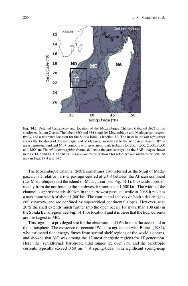
Fig. 14.1 Detailed bathymetry and location of the Mozambique Channel (labelled MC) in the
southwest Indian Ocean. The labels MO and MA stand for Mozambique and Madagascar, respectively, and a reference location for the Sofala Bank is labelled SB. The inset in the top-left corner
shows the locations of Mozambique and Madagascar in relation to the African continent. White
areas represent land and black contours with grey areas mark isobaths for 200, 1,000, 2,000, 3,000
and 4,000 m. The white rectangular frames delineate the area surveyed in the SAR images shown
in Figs. 14.2 and 14.3. The black rectangular frame is shown for reference and outlines the detailed
area in Figs. 14.4 and 14.5
The Mozambique Channel (MC), sometimes also referred as the Strait of Madagascar, is a relative narrow passage centred at 20
◦ S between the African continent
(i.e. Mozambique) and the island of Madagascar (see Fig. 14.1). It extends approximately from the northeast to the southwest for more than 1,500 km. The width of the
channel is approximately 400 km in the narrowest passage, while at 20
◦ S it reaches
a maximum width of about 1,000 km. The continental shelves on both sides are generally narrow, and are confined by supercritical continental slopes. However, near
20
◦ S the shelf extends much further into the open ocean, for more than 100 km (in
the Sofala Bank region, see Fig. 14.1 for location) and it is there that the tidal currents
are the largest in MC.
This region is a privileged site for the observation of IWs both in the ocean and in
the atmosphere. The existence of oceanic IWs is in agreement with Baines (1982),
who estimated tidal energy fluxes from several shelf regions of the world’s oceans,
and showed that MC was among the 12 most energetic regions for IT generation.
Here, the (semidiurnal) barotropic tidal ranges are over 7 m, and the barotropic
currents typically exceed 0.50 ms
−1 at spring-tides, with significant spring-neap
J. M. Magalhaes et al.
Fig. 14.1 Detailed bathymetry and location of the Mozambique Channel (labelled MC) in the
southwest Indian Ocean. The labels MO and MA stand for Mozambique and Madagascar, respectively, and a reference location for the Sofala Bank is labelled SB. The inset in the top-left corner
shows the locations of Mozambique and Madagascar in relation to the African continent. White
areas represent land and black contours with grey areas mark isobaths for 200, 1,000, 2,000, 3,000
and 4,000 m. The white rectangular frames delineate the area surveyed in the SAR images shown
in Figs. 14.2 and 14.3. The black rectangular frame is shown for reference and outlines the detailed
area in Figs. 14.4 and 14.5
The Mozambique Channel (MC), sometimes also referred as the Strait of Madagascar, is a relative narrow passage centred at 20
◦ S between the African continent
(i.e. Mozambique) and the island of Madagascar (see Fig. 14.1). It extends approximately from the northeast to the southwest for more than 1,500 km. The width of the
channel is approximately 400 km in the narrowest passage, while at 20
◦ S it reaches
a maximum width of about 1,000 km. The continental shelves on both sides are generally narrow, and are confined by supercritical continental slopes. However, near
20
◦ S the shelf extends much further into the open ocean, for more than 100 km (in
the Sofala Bank region, see Fig. 14.1 for location) and it is there that the tidal currents
are the largest in MC.
This region is a privileged site for the observation of IWs both in the ocean and in
the atmosphere. The existence of oceanic IWs is in agreement with Baines (1982),
who estimated tidal energy fluxes from several shelf regions of the world’s oceans,
and showed that MC was among the 12 most energetic regions for IT generation.
Here, the (semidiurnal) barotropic tidal ranges are over 7 m, and the barotropic
currents typically exceed 0.50 ms
−1 at spring-tides, with significant spring-neap