

170
H. Siegel et al.
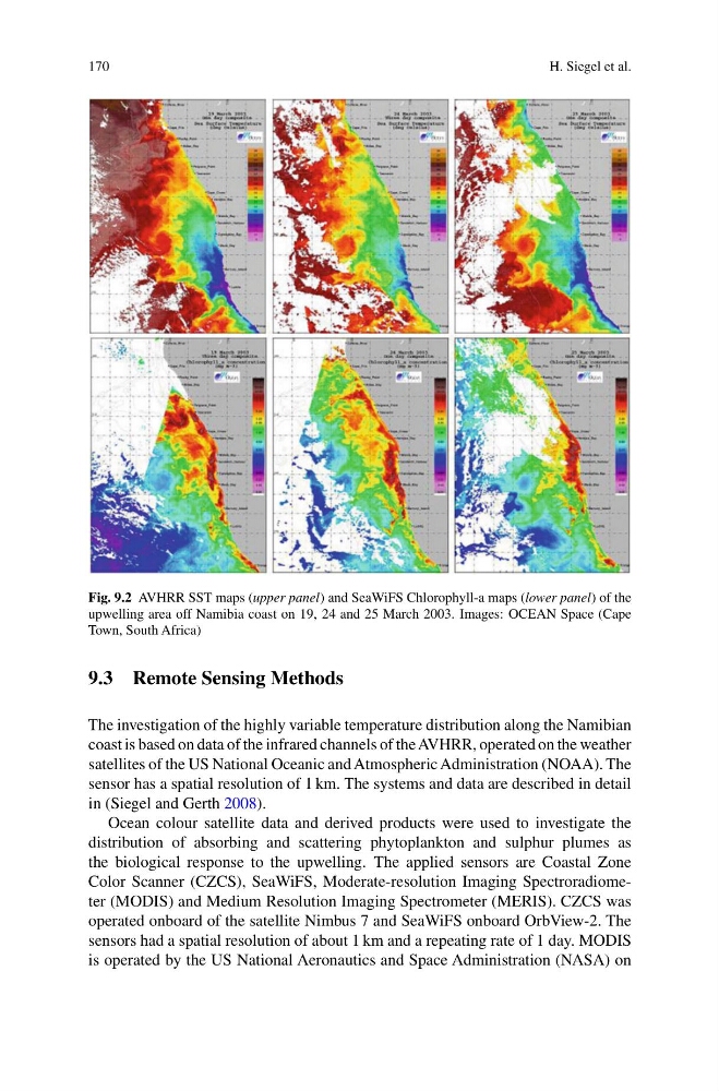
Fig. 9.2 AVHRR SST maps (upper panel) and SeaWiFS Chlorophyll-a maps (lower panel) of the
upwelling area off Namibia coast on 19, 24 and 25 March 2003. Images: OCEAN Space (Cape
Town, South Africa)
9.3 Remote Sensing Methods
The investigation of the highly variable temperature distribution along the Namibian
coast is based on data of the infrared channels of the AVHRR, operated on the weather
satellites of the US National Oceanic and Atmospheric Administration (NOAA). The
sensor has a spatial resolution of 1 km. The systems and data are described in detail
in (Siegel and Gerth 2008).
Ocean colour satellite data and derived products were used to investigate the
distribution of absorbing and scattering phytoplankton and sulphur plumes as
the biological response to the upwelling. The applied sensors are Coastal Zone
Color Scanner (CZCS), SeaWiFS, Moderate-resolution Imaging Spectroradiometer (MODIS) and Medium Resolution Imaging Spectrometer (MERIS). CZCS was
operated onboard of the satellite Nimbus 7 and SeaWiFS onboard OrbView-2. The
sensors had a spatial resolution of about 1 km and a repeating rate of 1 day. MODIS
is operated by the US National Aeronautics and Space Administration (NASA) on
H. Siegel et al.
Fig. 9.2 AVHRR SST maps (upper panel) and SeaWiFS Chlorophyll-a maps (lower panel) of the
upwelling area off Namibia coast on 19, 24 and 25 March 2003. Images: OCEAN Space (Cape
Town, South Africa)
9.3 Remote Sensing Methods
The investigation of the highly variable temperature distribution along the Namibian
coast is based on data of the infrared channels of the AVHRR, operated on the weather
satellites of the US National Oceanic and Atmospheric Administration (NOAA). The
sensor has a spatial resolution of 1 km. The systems and data are described in detail
in (Siegel and Gerth 2008).
Ocean colour satellite data and derived products were used to investigate the
distribution of absorbing and scattering phytoplankton and sulphur plumes as
the biological response to the upwelling. The applied sensors are Coastal Zone
Color Scanner (CZCS), SeaWiFS, Moderate-resolution Imaging Spectroradiometer (MODIS) and Medium Resolution Imaging Spectrometer (MERIS). CZCS was
operated onboard of the satellite Nimbus 7 and SeaWiFS onboard OrbView-2. The
sensors had a spatial resolution of about 1 km and a repeating rate of 1 day. MODIS
is operated by the US National Aeronautics and Space Administration (NASA) on