

98
L. G.-Weil et al.
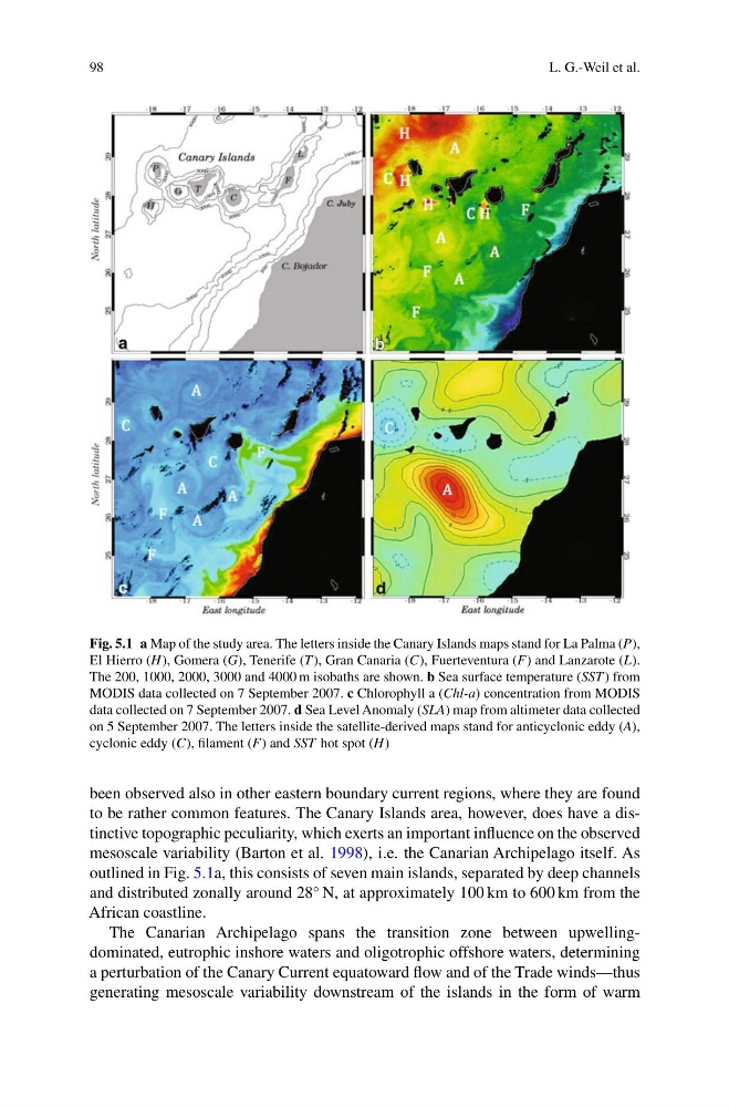
Fig. 5.1 a Map of the study area. The letters inside the Canary Islands maps stand for La Palma (P),
El Hierro (H), Gomera (G), Tenerife (T ), Gran Canaria (C), Fuerteventura (F) and Lanzarote (L).
The 200, 1000, 2000, 3000 and 4000 m isobaths are shown. b Sea surface temperature (SST ) from
MODIS data collected on 7 September 2007. c Chlorophyll a (Chl-a) concentration from MODIS
data collected on 7 September 2007. d Sea Level Anomaly (SLA) map from altimeter data collected
on 5 September 2007. The letters inside the satellite-derived maps stand for anticyclonic eddy (A),
cyclonic eddy (C), filament (F) and SST hot spot (H)
been observed also in other eastern boundary current regions, where they are found
to be rather common features. The Canary Islands area, however, does have a distinctive topographic peculiarity, which exerts an important influence on the observed
mesoscale variability (Barton et al. 1998), i.e. the Canarian Archipelago itself. As
outlined in Fig. 5.1a, this consists of seven main islands, separated by deep channels
and distributed zonally around 28
◦ N, at approximately 100 km to 600 km from the
African coastline.
The Canarian Archipelago spans the transition zone between upwellingdominated, eutrophic inshore waters and oligotrophic offshore waters, determining
a perturbation of the Canary Current equatoward flow and of the Trade winds—thus
generating mesoscale variability downstream of the islands in the form of warm
L. G.-Weil et al.
Fig. 5.1 a Map of the study area. The letters inside the Canary Islands maps stand for La Palma (P),
El Hierro (H), Gomera (G), Tenerife (T ), Gran Canaria (C), Fuerteventura (F) and Lanzarote (L).
The 200, 1000, 2000, 3000 and 4000 m isobaths are shown. b Sea surface temperature (SST ) from
MODIS data collected on 7 September 2007. c Chlorophyll a (Chl-a) concentration from MODIS
data collected on 7 September 2007. d Sea Level Anomaly (SLA) map from altimeter data collected
on 5 September 2007. The letters inside the satellite-derived maps stand for anticyclonic eddy (A),
cyclonic eddy (C), filament (F) and SST hot spot (H)
been observed also in other eastern boundary current regions, where they are found
to be rather common features. The Canary Islands area, however, does have a distinctive topographic peculiarity, which exerts an important influence on the observed
mesoscale variability (Barton et al. 1998), i.e. the Canarian Archipelago itself. As
outlined in Fig. 5.1a, this consists of seven main islands, separated by deep channels
and distributed zonally around 28
◦ N, at approximately 100 km to 600 km from the
African coastline.
The Canarian Archipelago spans the transition zone between upwellingdominated, eutrophic inshore waters and oligotrophic offshore waters, determining
a perturbation of the Canary Current equatoward flow and of the Trade winds—thus
generating mesoscale variability downstream of the islands in the form of warm