

300
P.L. Colin
US – Ultrasound Imaging
Ultrasound imaging, using equipment designed for medical use on humans, has
been used to sex and assess gonad condition of red hind, Epinephelus guttatus
(Whiteman et al. 2005 ) from a spawning aggregation, as well as striped bass, Morone
saxatilis (Will et al. 2002 ) . Such data collection is usually part of a study in which
fi sh are subsequently tagged and released (Nemeth 2005 ) .
UV – Underwater Visual Census
Numerous methods have been developed for Underwater Visual Censuses (UVC)
and UVC is conducted for many purposes. It is extremely important to apply an
appropriate methodology for UVC surveys for these to be meaningful, repeatable
and consistent. However, most standard UVC surveys of aggregations have a single,
total count transect (either permanent or random) run through the aggregation area.
While simple and an approach widely used for general surveys of reef fi sh diversity
and abundance, the data generated have only limited use for aggregations because
of the dynamic nature of aggregations in the short term over both time and within a
small area, the often large numbers of species involved and the critical importance
of timing of surveys. If single permanent transects are subdivided into segments,
much more information is produced (Fig. 9.5 ) especially if multiple transects are
used. “GPS Density Surveys”, considered previously, are useful in some (but not
all) cases (Fig. 9.1 ). If feasible, they provide the best survey information among
present techniques, and are discussed further below.
VR – Video Recording
Underwater video recording, like underwater photography, is an important means of
documenting behaviour of aggregating and spawning fi shes. If done in a consistent
and controlled manner, additional data can be derived from video recordings beyond
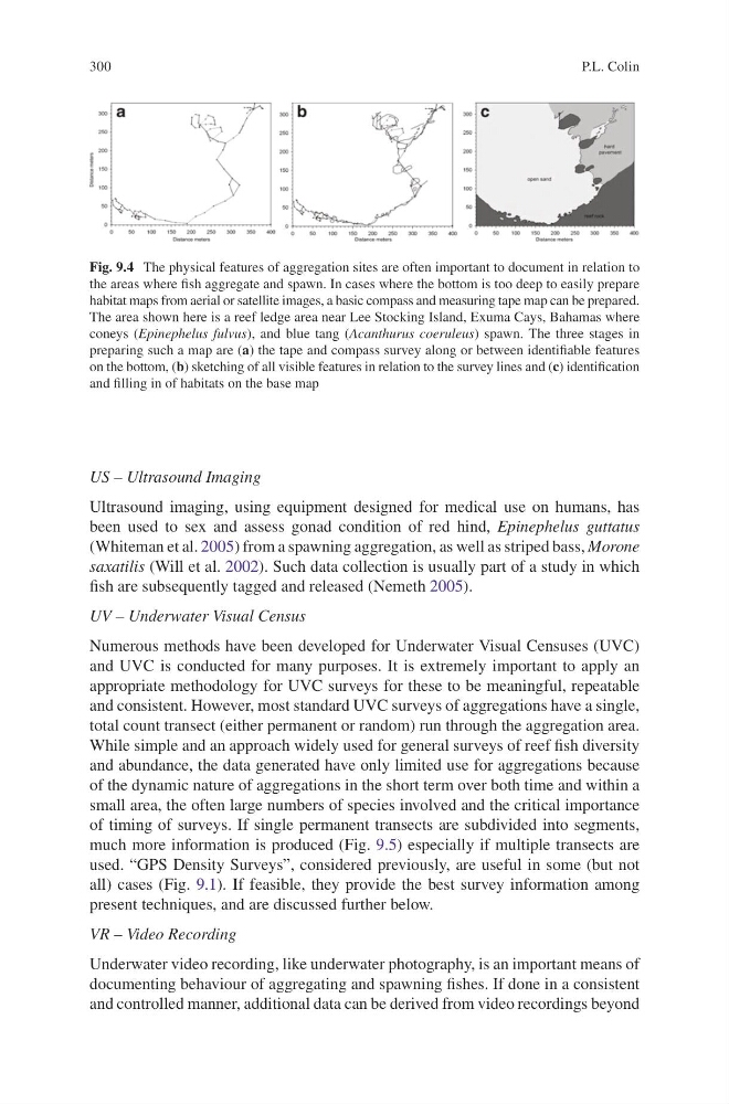
Fig. 9.4 The physical features of aggregation sites are often important to document in relation to
the areas where fi sh aggregate and spawn. In cases where the bottom is too deep to easily prepare
habitat maps from aerial or satellite images, a basic compass and measuring tape map can be prepared.
The area shown here is a reef ledge area near Lee Stocking Island, Exuma Cays, Bahamas where
coneys ( Epinephelus fulvus ), and blue tang ( Acanthurus coeruleus ) spawn. The three stages in
preparing such a map are ( a ) the tape and compass survey along or between identifi able features
on the bottom, ( b ) sketching of all visible features in relation to the survey lines and ( c ) identifi cation
and fi lling in of habitats on the base map
P.L. Colin
US – Ultrasound Imaging
Ultrasound imaging, using equipment designed for medical use on humans, has
been used to sex and assess gonad condition of red hind, Epinephelus guttatus
(Whiteman et al. 2005 ) from a spawning aggregation, as well as striped bass, Morone
saxatilis (Will et al. 2002 ) . Such data collection is usually part of a study in which
fi sh are subsequently tagged and released (Nemeth 2005 ) .
UV – Underwater Visual Census
Numerous methods have been developed for Underwater Visual Censuses (UVC)
and UVC is conducted for many purposes. It is extremely important to apply an
appropriate methodology for UVC surveys for these to be meaningful, repeatable
and consistent. However, most standard UVC surveys of aggregations have a single,
total count transect (either permanent or random) run through the aggregation area.
While simple and an approach widely used for general surveys of reef fi sh diversity
and abundance, the data generated have only limited use for aggregations because
of the dynamic nature of aggregations in the short term over both time and within a
small area, the often large numbers of species involved and the critical importance
of timing of surveys. If single permanent transects are subdivided into segments,
much more information is produced (Fig. 9.5 ) especially if multiple transects are
used. “GPS Density Surveys”, considered previously, are useful in some (but not
all) cases (Fig. 9.1 ). If feasible, they provide the best survey information among
present techniques, and are discussed further below.
VR – Video Recording
Underwater video recording, like underwater photography, is an important means of
documenting behaviour of aggregating and spawning fi shes. If done in a consistent
and controlled manner, additional data can be derived from video recordings beyond
Fig. 9.4 The physical features of aggregation sites are often important to document in relation to
the areas where fi sh aggregate and spawn. In cases where the bottom is too deep to easily prepare
habitat maps from aerial or satellite images, a basic compass and measuring tape map can be prepared.
The area shown here is a reef ledge area near Lee Stocking Island, Exuma Cays, Bahamas where
coneys ( Epinephelus fulvus ), and blue tang ( Acanthurus coeruleus ) spawn. The three stages in
preparing such a map are ( a ) the tape and compass survey along or between identifi able features
on the bottom, ( b ) sketching of all visible features in relation to the survey lines and ( c ) identifi cation
and fi lling in of habitats on the base map