

183
10 South Indian Trawl Fisheries – Assessing Their Governability
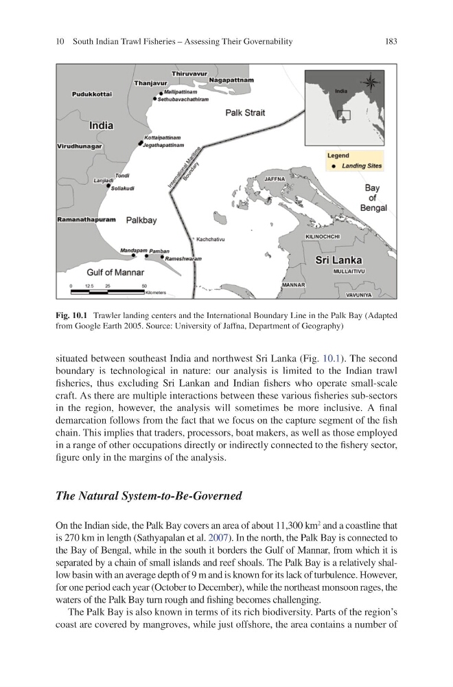
situated between southeast India and northwest Sri Lanka (Fig. 10.1 ). The second
boundary is technological in nature: our analysis is limited to the Indian trawl
fi sheries, thus excluding Sri Lankan and Indian fi shers who operate small-scale
craft. As there are multiple interactions between these various fi sheries sub-sectors
in the region, however, the analysis will sometimes be more inclusive. A fi nal
demarcation follows from the fact that we focus on the capture segment of the fi sh
chain. This implies that traders, processors, boat makers, as well as those employed
in a range of other occupations directly or indirectly connected to the fi shery sector,
fi gure only in the margins of the analysis.
The Natural System-to-Be-Governed
On the Indian side, the Palk Bay covers an area of about 11,300 km
2 and a coastline that
is 270 km in length (Sathyapalan et al. 2007 ) . In the north, the Palk Bay is connected to
the Bay of Bengal, while in the south it borders the Gulf of Mannar, from which it is
separated by a chain of small islands and reef shoals. The Palk Bay is a relatively shallow basin with an average depth of 9 m and is known for its lack of turbulence. However,
for one period each year (October to December), while the northeast monsoon rages, the
waters of the Palk Bay turn rough and fi shing becomes challenging.
The Palk Bay is also known in terms of its rich biodiversity. Parts of the region’s
coast are covered by mangroves, while just offshore, the area contains a number of
Fig. 10.1 Trawler landing centers and the International Boundary Line in the Palk Bay (Adapted
from Google Earth 2005. Source: University of Jaffna, Department of Geography)
10 South Indian Trawl Fisheries – Assessing Their Governability
situated between southeast India and northwest Sri Lanka (Fig. 10.1 ). The second
boundary is technological in nature: our analysis is limited to the Indian trawl
fi sheries, thus excluding Sri Lankan and Indian fi shers who operate small-scale
craft. As there are multiple interactions between these various fi sheries sub-sectors
in the region, however, the analysis will sometimes be more inclusive. A fi nal
demarcation follows from the fact that we focus on the capture segment of the fi sh
chain. This implies that traders, processors, boat makers, as well as those employed
in a range of other occupations directly or indirectly connected to the fi shery sector,
fi gure only in the margins of the analysis.
The Natural System-to-Be-Governed
On the Indian side, the Palk Bay covers an area of about 11,300 km
2 and a coastline that
is 270 km in length (Sathyapalan et al. 2007 ) . In the north, the Palk Bay is connected to
the Bay of Bengal, while in the south it borders the Gulf of Mannar, from which it is
separated by a chain of small islands and reef shoals. The Palk Bay is a relatively shallow basin with an average depth of 9 m and is known for its lack of turbulence. However,
for one period each year (October to December), while the northeast monsoon rages, the
waters of the Palk Bay turn rough and fi shing becomes challenging.
The Palk Bay is also known in terms of its rich biodiversity. Parts of the region’s
coast are covered by mangroves, while just offshore, the area contains a number of
Fig. 10.1 Trawler landing centers and the International Boundary Line in the Palk Bay (Adapted
from Google Earth 2005. Source: University of Jaffna, Department of Geography)