

Within the visible near-infrared wavelengths, the detection of areas affected by a
floating oil spill can make use of spectral differences between oil and water
[90]. With respect to satellite, airborne hyperspectral and thermal infrared data
have free-overcast collection and free-scheduling advantages. In particular, the
timeframe for collecting and processing the data is important for oil spill surveillance and monitoring; data should be available in real-time and permit easy
interpretation and use. Time is particularly critical for an oil spill occurring in
rivers as water current can rapidly spread the oil over a long area in a short time.
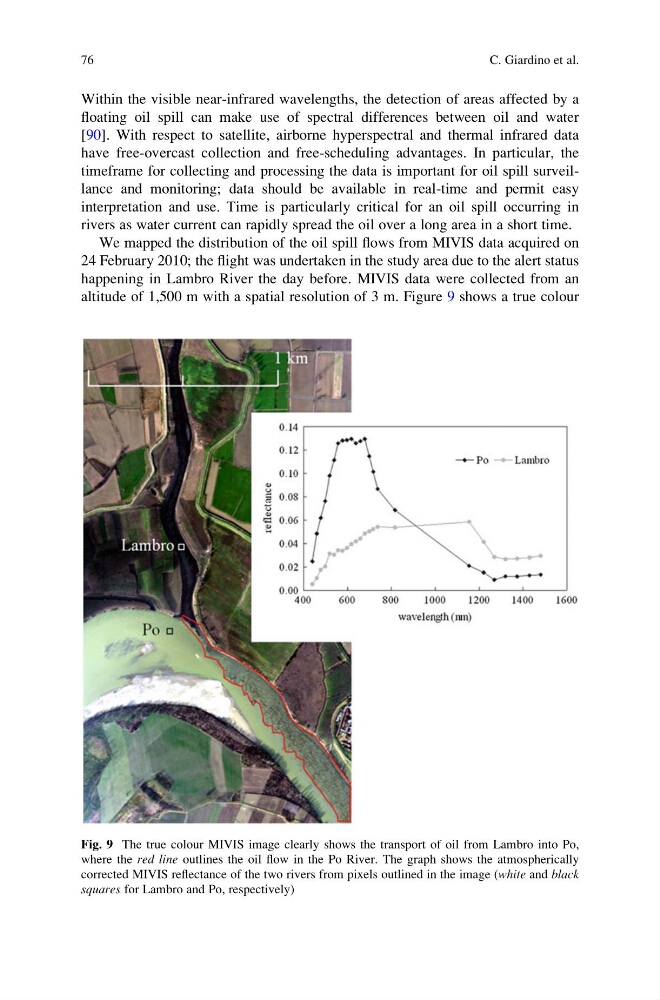
We mapped the distribution of the oil spill flows from MIVIS data acquired on
24 February 2010; the flight was undertaken in the study area due to the alert status
happening in Lambro River the day before. MIVIS data were collected from an
altitude of 1,500 m with a spatial resolution of 3 m. Figure 9 shows a true colour
Fig. 9 The true colour MIVIS image clearly shows the transport of oil from Lambro into Po,
where the red line outlines the oil flow in the Po River. The graph shows the atmospherically
corrected MIVIS reflectance of the two rivers from pixels outlined in the image (white and black
squares for Lambro and Po, respectively)
76
C. Giardino et al.
floating oil spill can make use of spectral differences between oil and water
[90]. With respect to satellite, airborne hyperspectral and thermal infrared data
have free-overcast collection and free-scheduling advantages. In particular, the
timeframe for collecting and processing the data is important for oil spill surveillance and monitoring; data should be available in real-time and permit easy
interpretation and use. Time is particularly critical for an oil spill occurring in
rivers as water current can rapidly spread the oil over a long area in a short time.
We mapped the distribution of the oil spill flows from MIVIS data acquired on
24 February 2010; the flight was undertaken in the study area due to the alert status
happening in Lambro River the day before. MIVIS data were collected from an
altitude of 1,500 m with a spatial resolution of 3 m. Figure 9 shows a true colour
Fig. 9 The true colour MIVIS image clearly shows the transport of oil from Lambro into Po,
where the red line outlines the oil flow in the Po River. The graph shows the atmospherically
corrected MIVIS reflectance of the two rivers from pixels outlined in the image (white and black
squares for Lambro and Po, respectively)
76
C. Giardino et al.