

represents a modern technology. In particular, since late 1990s airborne MIVIS
hyperspectral data have been mainly used in Italy to assess inland water quality [61].
The hyperspectral Multispectral Infrared Visible Imaging Spectrometer
(MIVIS) sensor [62, 63] is a Daedalus modular system composed of four imaging
spectrometers which simultaneously record radiation coming from the Earth in
102 spectral channels from the visible to thermal infrared red spectral range
(wavelengths ranging between 0.43 and 12.7 μm). MIVIS has been demonstrated
to be a powerful instrument for mapping purposes in many different natural
contexts, including lakes, lagoons and wetlands (e.g. [64, 65]). Results showed
the great potential of the MIVIS sensor to clarify complex dynamics between
primary producers [66], track their evolution [67], evidence complex patterns in
the distribution of submerged aquatic vegetation and SPM [68], map macrophyte
distribution and changes [67, 69, 70] and finally provide useful information to
ecologists and environmental managers.
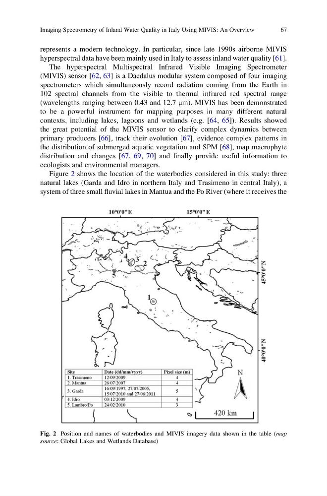
Figure 2 shows the location of the waterbodies considered in this study: three
natural lakes (Garda and Idro in northern Italy and Trasimeno in central Italy), a
system of three small fluvial lakes in Mantua and the Po River (where it receives the
Fig. 2 Position and names of waterbodies and MIVIS imagery data shown in the table (map
source: Global Lakes and Wetlands Database)
Imaging Spectrometry of Inland Water Quality in Italy Using MIVIS: An Overview
67
hyperspectral data have been mainly used in Italy to assess inland water quality [61].
The hyperspectral Multispectral Infrared Visible Imaging Spectrometer
(MIVIS) sensor [62, 63] is a Daedalus modular system composed of four imaging
spectrometers which simultaneously record radiation coming from the Earth in
102 spectral channels from the visible to thermal infrared red spectral range
(wavelengths ranging between 0.43 and 12.7 μm). MIVIS has been demonstrated
to be a powerful instrument for mapping purposes in many different natural
contexts, including lakes, lagoons and wetlands (e.g. [64, 65]). Results showed
the great potential of the MIVIS sensor to clarify complex dynamics between
primary producers [66], track their evolution [67], evidence complex patterns in
the distribution of submerged aquatic vegetation and SPM [68], map macrophyte
distribution and changes [67, 69, 70] and finally provide useful information to
ecologists and environmental managers.
Figure 2 shows the location of the waterbodies considered in this study: three
natural lakes (Garda and Idro in northern Italy and Trasimeno in central Italy), a
system of three small fluvial lakes in Mantua and the Po River (where it receives the
Fig. 2 Position and names of waterbodies and MIVIS imagery data shown in the table (map
source: Global Lakes and Wetlands Database)
Imaging Spectrometry of Inland Water Quality in Italy Using MIVIS: An Overview
67