

conditions, irrigation management, and studies of desertification, all of which are
especially important in arid and semiarid regions.
Soil moisture also plays a significant role in forecasting arid region droughts. In
dry regions of the world, like the Sahel, cloud formation and the rate and distribution of precipitation are partly controlled by the wetness of the soil [26]. The
wetness of the terrain influences how much energy it absorbs from the Sun,
which in turn affects atmospheric convection, cloud formation, and precipitation.
This relationship creates a feedback loop, where rainfall affects the chances of
additional precipitation in the days that follow. Thus, a positive feedback would
promote floods and drought.
Because microwave radiation is sensitive to soil moisture, microwave remote
sensors provide a unique capability for mapping soil moisture over large areas of
the Earth’s land surface [27]. Both active radars and passive microwave systems
can sense soil moisture. Microwave radiometers detect the brightness temperature,
which equals the product of the emissivity and the surface temperature of the soil.
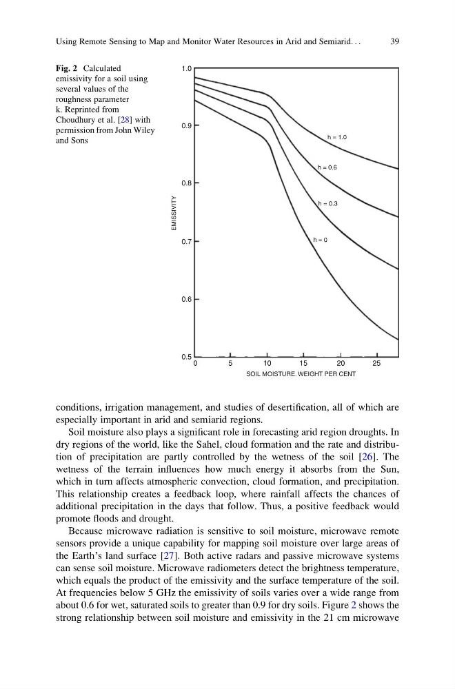
At frequencies below 5 GHz the emissivity of soils varies over a wide range from
about 0.6 for wet, saturated soils to greater than 0.9 for dry soils. Figure 2 shows the
strong relationship between soil moisture and emissivity in the 21 cm microwave
1.0
0.9
0.8
0.7
EMISSIVITY
0.6
0.5
0
5
10
15
20
25
SOIL MOISTURE. WEIGHT PER CENT
h = 1.0
h = 0.6
h = 0.3
h = 0
Fig. 2 Calculated
emissivity for a soil using
several values of the
roughness parameter
k. Reprinted from
Choudhury et al. [28] with
permission from John Wiley
and Sons
Using Remote Sensing to Map and Monitor Water Resources in Arid and Semiarid. . .
39
especially important in arid and semiarid regions.
Soil moisture also plays a significant role in forecasting arid region droughts. In
dry regions of the world, like the Sahel, cloud formation and the rate and distribution of precipitation are partly controlled by the wetness of the soil [26]. The
wetness of the terrain influences how much energy it absorbs from the Sun,
which in turn affects atmospheric convection, cloud formation, and precipitation.
This relationship creates a feedback loop, where rainfall affects the chances of
additional precipitation in the days that follow. Thus, a positive feedback would
promote floods and drought.
Because microwave radiation is sensitive to soil moisture, microwave remote
sensors provide a unique capability for mapping soil moisture over large areas of
the Earth’s land surface [27]. Both active radars and passive microwave systems
can sense soil moisture. Microwave radiometers detect the brightness temperature,
which equals the product of the emissivity and the surface temperature of the soil.
At frequencies below 5 GHz the emissivity of soils varies over a wide range from
about 0.6 for wet, saturated soils to greater than 0.9 for dry soils. Figure 2 shows the
strong relationship between soil moisture and emissivity in the 21 cm microwave
1.0
0.9
0.8
0.7
EMISSIVITY
0.6
0.5
0
5
10
15
20
25
SOIL MOISTURE. WEIGHT PER CENT
h = 1.0
h = 0.6
h = 0.3
h = 0
Fig. 2 Calculated
emissivity for a soil using
several values of the
roughness parameter
k. Reprinted from
Choudhury et al. [28] with
permission from John Wiley
and Sons
Using Remote Sensing to Map and Monitor Water Resources in Arid and Semiarid. . .
39