

Until recently, water use studies across the United States, and around the world,
have been done at relatively coarse spatial and temporal resolutions, primarily
because of data limitations. Temporal resolution has typically been annual or
decadal, and spatial resolution has been generally at the national scale for global
studies [9] and at the county or state scale for US studies [10]. However, water use
analyses at finer scales are desirable because of the high variability of water
availability in most regions [11, 12].
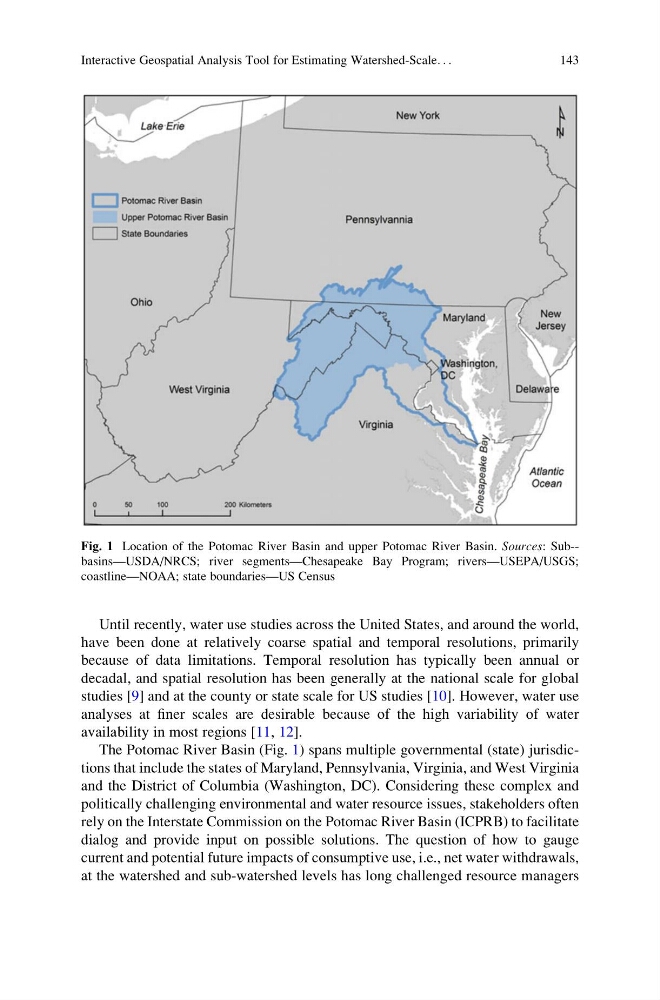
The Potomac River Basin (Fig. 1) spans multiple governmental (state) jurisdictions that include the states of Maryland, Pennsylvania, Virginia, and West Virginia
and the District of Columbia (Washington, DC). Considering these complex and
politically challenging environmental and water resource issues, stakeholders often
rely on the Interstate Commission on the Potomac River Basin (ICPRB) to facilitate
dialog and provide input on possible solutions. The question of how to gauge
current and potential future impacts of consumptive use, i.e., net water withdrawals,
at the watershed and sub-watershed levels has long challenged resource managers
Fig. 1 Location of the Potomac River Basin and upper Potomac River Basin. Sources: Sub-basins—USDA/NRCS; river segments—Chesapeake Bay Program; rivers—USEPA/USGS;
coastline—NOAA; state boundaries—US Census
Interactive Geospatial Analysis Tool for Estimating Watershed-Scale. . .
143
have been done at relatively coarse spatial and temporal resolutions, primarily
because of data limitations. Temporal resolution has typically been annual or
decadal, and spatial resolution has been generally at the national scale for global
studies [9] and at the county or state scale for US studies [10]. However, water use
analyses at finer scales are desirable because of the high variability of water
availability in most regions [11, 12].
The Potomac River Basin (Fig. 1) spans multiple governmental (state) jurisdictions that include the states of Maryland, Pennsylvania, Virginia, and West Virginia
and the District of Columbia (Washington, DC). Considering these complex and
politically challenging environmental and water resource issues, stakeholders often
rely on the Interstate Commission on the Potomac River Basin (ICPRB) to facilitate
dialog and provide input on possible solutions. The question of how to gauge
current and potential future impacts of consumptive use, i.e., net water withdrawals,
at the watershed and sub-watershed levels has long challenged resource managers
Fig. 1 Location of the Potomac River Basin and upper Potomac River Basin. Sources: Sub-basins—USDA/NRCS; river segments—Chesapeake Bay Program; rivers—USEPA/USGS;
coastline—NOAA; state boundaries—US Census
Interactive Geospatial Analysis Tool for Estimating Watershed-Scale. . .
143