

(SeaWiFS), and MODIS, to monitor oceans and coastal areas. Each sensor yielded
advances in sensor technology, and as noted earlier, they provide useful information on chlorophyll and other optically related variables using analytical and
semi-analytical algorithms. Their spatial resolutions, however, are suitable only for
large lakes (> 900, 1,100, and 400 ha, respectively). MODIS has been used
effectively for water quality studies on some of the Laurentian Great Lakes [77,
78]. Another important problem regarding inland lake applications of these sensors
is that their spectral bands were designed for marine waters. They lack a critically
important red-edge band needed for most inland water studies.
The next advancement for remote sensing of regional water quality of lakes will
come from the European Space Agency (ESA) Sentinel-2 satellites, which at the time
of this writing are scheduled for launch in April 2015 (Sentinel-2A) and approximately
one year later for Sentinel-2B. Although these satellites were designed primarily for
land observations, their improved spatial resolution (10, 20, and 60 m), spectral bands
(narrower green and red, red edge, and 3 NIR bands), and temporal coverage (every
3–5 days) will greatly enhance the capabilities to assess optically related water quality
characteristics (e.g., chlorophyll, CDOM, SS min ) in inland lakes. Landsat 8 and
Sentinel-2 have specific SWIR bands selected for atmospheric corrections and cloud
screening that will greatly enhance their use for routine monitoring.
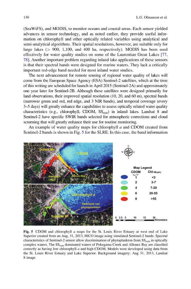
An example of water quality maps for chlorophyll a and CDOM created from
Sentinel-2 bands is shown in Fig. 5 for the SLRE. In this case, the band information
Fig. 5 CDOM and chlorophyll a maps for the St. Louis River Estuary at west end of Lake
Superior created from an Aug. 31, 2013, HICO image using simulated Sentinel-2 bands. Spectral
characteristics of Sentinel-2 sensor allow discrimination of phytoplankton from SS min in optically
complex waters. The SS min dominated waters of Pokegama Creek and Allouez Bay are classified
correctly as having low chlorophyll a and high CDOM. Models were developed using data from
the St. Louis River Estuary and Lake Superior. Background imagery: Aug 31, 2013, Landsat
8 image
130
L.G. Olmanson et al.
advances in sensor technology, and as noted earlier, they provide useful information on chlorophyll and other optically related variables using analytical and
semi-analytical algorithms. Their spatial resolutions, however, are suitable only for
large lakes (> 900, 1,100, and 400 ha, respectively). MODIS has been used
effectively for water quality studies on some of the Laurentian Great Lakes [77,
78]. Another important problem regarding inland lake applications of these sensors
is that their spectral bands were designed for marine waters. They lack a critically
important red-edge band needed for most inland water studies.
The next advancement for remote sensing of regional water quality of lakes will
come from the European Space Agency (ESA) Sentinel-2 satellites, which at the time
of this writing are scheduled for launch in April 2015 (Sentinel-2A) and approximately
one year later for Sentinel-2B. Although these satellites were designed primarily for
land observations, their improved spatial resolution (10, 20, and 60 m), spectral bands
(narrower green and red, red edge, and 3 NIR bands), and temporal coverage (every
3–5 days) will greatly enhance the capabilities to assess optically related water quality
characteristics (e.g., chlorophyll, CDOM, SS min ) in inland lakes. Landsat 8 and
Sentinel-2 have specific SWIR bands selected for atmospheric corrections and cloud
screening that will greatly enhance their use for routine monitoring.
An example of water quality maps for chlorophyll a and CDOM created from
Sentinel-2 bands is shown in Fig. 5 for the SLRE. In this case, the band information
Fig. 5 CDOM and chlorophyll a maps for the St. Louis River Estuary at west end of Lake
Superior created from an Aug. 31, 2013, HICO image using simulated Sentinel-2 bands. Spectral
characteristics of Sentinel-2 sensor allow discrimination of phytoplankton from SS min in optically
complex waters. The SS min dominated waters of Pokegama Creek and Allouez Bay are classified
correctly as having low chlorophyll a and high CDOM. Models were developed using data from
the St. Louis River Estuary and Lake Superior. Background imagery: Aug 31, 2013, Landsat
8 image
130
L.G. Olmanson et al.