

6
1.2 Healthy Rivers
Because rivers are ecosystems, throughout this book I refer to the physical environment of a river as the river corridor, rather than just the channel. A river corridor
includes the main channel and secondary channels, where these are present; the
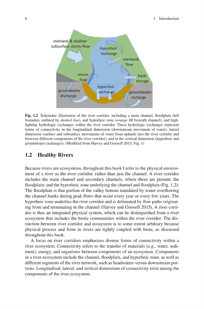
floodplain; and the hyporheic zone underlying the channel and floodplain (Fig. 1.2).
The floodplain is that portion of the valley bottom inundated by water overflowing
the channel banks during peak flows that occur every year or every few years. The
hyporheic zone underlies the river corridor and is delineated by flow paths originating from and terminating in the channel (Harvey and Gooseff 2015). A river corridor is thus an integrated physical system, which can be distinguished from a river
ecosystem that includes the biotic communities within the river corridor. The distinction between river corridor and ecosystem is to some extent arbitrary because
physical process and form in rivers are tightly coupled with biota, as discussed
throughout this book.
A focus on river corridors emphasizes diverse forms of connectivity within a
river ecosystem. Connectivity refers to the transfer of materials (e.g., water, sediment), energy, and organisms between components of an ecosystem. Components
in a river ecosystem include the channel, floodplain, and hyporheic zone, as well as
different segments of the river network, such as headwaters versus downstream portions. Longitudinal, lateral, and vertical dimensions of connectivity exist among the
components of the river ecosystem.
Fig. 1.2 Schematic illustration of the river corridor, including a main channel, floodplain (left
boundary outlined by dashed line), and hyporheic zone (orange fill beneath channel), and highlighting hydrologic exchanges within the river corridor. These hydrologic exchanges represent
forms of connectivity in the longitudinal dimension (downstream movement of water), lateral
dimension (surface and subsurface movements of water from uplands into the river corridor and
between different components of the river corridor), and in the vertical dimension (hyporheic and
groundwater exchanges). (Modified from Harvey and Gooseff 2015, Fig. 1)
1 Introduction
1.2 Healthy Rivers
Because rivers are ecosystems, throughout this book I refer to the physical environment of a river as the river corridor, rather than just the channel. A river corridor
includes the main channel and secondary channels, where these are present; the
floodplain; and the hyporheic zone underlying the channel and floodplain (Fig. 1.2).
The floodplain is that portion of the valley bottom inundated by water overflowing
the channel banks during peak flows that occur every year or every few years. The
hyporheic zone underlies the river corridor and is delineated by flow paths originating from and terminating in the channel (Harvey and Gooseff 2015). A river corridor is thus an integrated physical system, which can be distinguished from a river
ecosystem that includes the biotic communities within the river corridor. The distinction between river corridor and ecosystem is to some extent arbitrary because
physical process and form in rivers are tightly coupled with biota, as discussed
throughout this book.
A focus on river corridors emphasizes diverse forms of connectivity within a
river ecosystem. Connectivity refers to the transfer of materials (e.g., water, sediment), energy, and organisms between components of an ecosystem. Components
in a river ecosystem include the channel, floodplain, and hyporheic zone, as well as
different segments of the river network, such as headwaters versus downstream portions. Longitudinal, lateral, and vertical dimensions of connectivity exist among the
components of the river ecosystem.
Fig. 1.2 Schematic illustration of the river corridor, including a main channel, floodplain (left
boundary outlined by dashed line), and hyporheic zone (orange fill beneath channel), and highlighting hydrologic exchanges within the river corridor. These hydrologic exchanges represent
forms of connectivity in the longitudinal dimension (downstream movement of water), lateral
dimension (surface and subsurface movements of water from uplands into the river corridor and
between different components of the river corridor), and in the vertical dimension (hyporheic and
groundwater exchanges). (Modified from Harvey and Gooseff 2015, Fig. 1)
1 Introduction