

46
covers approximately 3,622 km
2
from Itapuã (Salvador) to the border with Sergipe
state, from the high tide line to the 500 m isobaths (Fig. 3.3). The main characteristic of this PA is a narrow continental shelf, approximately 15 km wide, with average
depths of 50 m (DHN 1995).
Whale-watching vessels departing from the port of Praia do Forte operate within
the North Coast Continental Shelf PA (Fig. 3.4). The vessels depart at different
times during the day, usually between 8 am and 2 pm and typically navigate for 2–3
h. Trips do not normally exceed 4 h in duration and vessels tend to navigate out in a
straight line for a maximum 15 km and then turn north or southwards, depending on
wind conditions, stopping to observe any whale groups spotted on the way, before
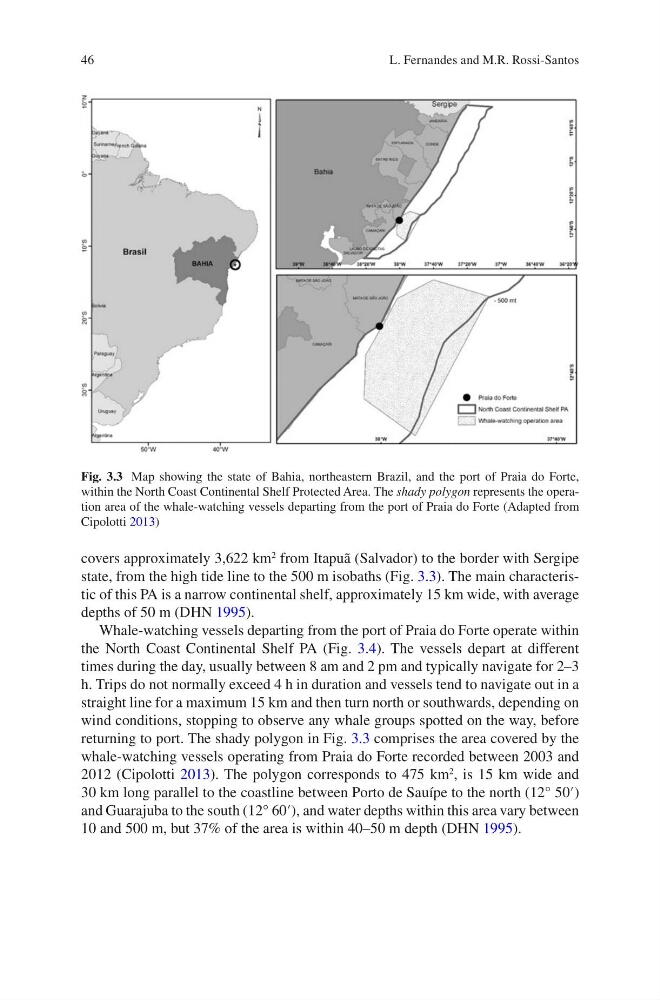
returning to port. The shady polygon in Fig. 3.3 comprises the area covered by the
whale-watching vessels operating from Praia do Forte recorded between 2003 and
2012 (Cipolotti 2013). The polygon corresponds to 475 km
2
, is 15 km wide and
30 km long parallel to the coastline between Porto de Sauípe to the north (12° 50′)
and Guarajuba to the south (12° 60′), and water depths within this area vary between
10 and 500 m, but 37% of the area is within 40–50 m depth (DHN 1995).
Fig. 3.3 Map showing the state of Bahia, northeastern Brazil, and the port of Praia do Forte,
within the North Coast Continental Shelf Protected Area. The shady polygon represents the operation area of the whale-watching vessels departing from the port of Praia do Forte (Adapted from
Cipolotti 2013)
L. Fernandes and M.R. Rossi-Santos
covers approximately 3,622 km
2
from Itapuã (Salvador) to the border with Sergipe
state, from the high tide line to the 500 m isobaths (Fig. 3.3). The main characteristic of this PA is a narrow continental shelf, approximately 15 km wide, with average
depths of 50 m (DHN 1995).
Whale-watching vessels departing from the port of Praia do Forte operate within
the North Coast Continental Shelf PA (Fig. 3.4). The vessels depart at different
times during the day, usually between 8 am and 2 pm and typically navigate for 2–3
h. Trips do not normally exceed 4 h in duration and vessels tend to navigate out in a
straight line for a maximum 15 km and then turn north or southwards, depending on
wind conditions, stopping to observe any whale groups spotted on the way, before
returning to port. The shady polygon in Fig. 3.3 comprises the area covered by the
whale-watching vessels operating from Praia do Forte recorded between 2003 and
2012 (Cipolotti 2013). The polygon corresponds to 475 km
2
, is 15 km wide and
30 km long parallel to the coastline between Porto de Sauípe to the north (12° 50′)
and Guarajuba to the south (12° 60′), and water depths within this area vary between
10 and 500 m, but 37% of the area is within 40–50 m depth (DHN 1995).
Fig. 3.3 Map showing the state of Bahia, northeastern Brazil, and the port of Praia do Forte,
within the North Coast Continental Shelf Protected Area. The shady polygon represents the operation area of the whale-watching vessels departing from the port of Praia do Forte (Adapted from
Cipolotti 2013)
L. Fernandes and M.R. Rossi-Santos