

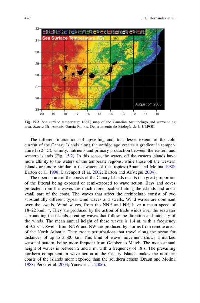
The different interactions of upwelling and, to a lesser extent, of the cold
current of the Canary Islands along the archipelago creates a gradient in temperature (&2 °C), salinity, nutrients and primary production between the eastern and
western islands (Fig. 15.2). In this sense, the waters off the eastern islands have
more affinity to the waters of the temperate regions, while those off the western
islands are more similar to the waters of the tropics (Braun and Molina 1988;
Barton et al. 1998; Davenport et al. 2002; Barton and Arístegui 2004).
The open nature of the coasts of the Canary Islands results in a great proportion
of the littoral being exposed or semi-exposed to wave action. Bays and coves
protected from the waves are much more localized along the islands and are a
small part of the coast. The waves that affect the archipelago consist of two
substantially different types: wind waves and swells. Wind waves are dominant
over the swells. Wind waves, from the NNE and NE, have a mean speed of
18–22 kmh
-1 . They are produced by the action of trade winds over the seawater
surrounding the islands, creating waves that follow the direction and intensity of
the winds. The mean annual height of these waves is 1.4 m, with a frequency
of 9.5 s
-1
. Swells from NNW and NW are produced by storms from remote areas
of the North Atlantic. They create perturbations that travel along the ocean for
distances of up to 3,500 km. This kind of wave movement shows a marked
seasonal pattern, being more frequent from October to March. The mean annual
height of waves is between 2 and 3 m, with a frequency of 18 s. The prevailing
northern component in wave action at the Canary Islands makes the northern
coasts of the islands more exposed than the southern coasts (Braun and Molina
1988; Pérez et al. 2003; Yanes et al. 2006).
Fig. 15.2 Sea surface temperatura (SST) map of the Canarian Arquipelago and surrounding
area. Source Dr. Antonio García Ramos, Departamento de Biología de la ULPGC
476
J. C. Hernández et al.
current of the Canary Islands along the archipelago creates a gradient in temperature (&2 °C), salinity, nutrients and primary production between the eastern and
western islands (Fig. 15.2). In this sense, the waters off the eastern islands have
more affinity to the waters of the temperate regions, while those off the western
islands are more similar to the waters of the tropics (Braun and Molina 1988;
Barton et al. 1998; Davenport et al. 2002; Barton and Arístegui 2004).
The open nature of the coasts of the Canary Islands results in a great proportion
of the littoral being exposed or semi-exposed to wave action. Bays and coves
protected from the waves are much more localized along the islands and are a
small part of the coast. The waves that affect the archipelago consist of two
substantially different types: wind waves and swells. Wind waves are dominant
over the swells. Wind waves, from the NNE and NE, have a mean speed of
18–22 kmh
-1 . They are produced by the action of trade winds over the seawater
surrounding the islands, creating waves that follow the direction and intensity of
the winds. The mean annual height of these waves is 1.4 m, with a frequency
of 9.5 s
-1
. Swells from NNW and NW are produced by storms from remote areas
of the North Atlantic. They create perturbations that travel along the ocean for
distances of up to 3,500 km. This kind of wave movement shows a marked
seasonal pattern, being more frequent from October to March. The mean annual
height of waves is between 2 and 3 m, with a frequency of 18 s. The prevailing
northern component in wave action at the Canary Islands makes the northern
coasts of the islands more exposed than the southern coasts (Braun and Molina
1988; Pérez et al. 2003; Yanes et al. 2006).
Fig. 15.2 Sea surface temperatura (SST) map of the Canarian Arquipelago and surrounding
area. Source Dr. Antonio García Ramos, Departamento de Biología de la ULPGC
476
J. C. Hernández et al.