

geological age of the islands and on the physicochemical characteristics of erupted
materials. The older islands (Fuerteventura, Lanzarote, Gran Canaria, La Gomera)
have been exposed longer to the action of erosive agents (waves, wind, runoff) and
therefore they have a wider platform than the younger islands (Tenerife, La Palma,
El Hierro) (Mitchell et al. 2003). In the case of El Hierro, the youngest island, the
edifice has hardly been remodeled and the insular platform is very small or nonexistent (Fig. 15.1b). Within each island, the extent of the platforms may differ.
They usually show greater development in the northern faces of the islands, which
are areas more highly exposed to erosive agents (Mitchell et al. 2003).
Along with erosion and the creation of offshore platforms, other underwater
structures and events have been recognized, such as rifts and massive landslides
(Urgeles et al. 1999; Masson et al. 2002; Mitchell et al. 2002). Rifts are the growth
axes of the islands that constitute their structural basis since they concentrate the
greatest amount of volcanic activity. Landslides are sudden and intense events that
generate large avalanches, caused by the gravitational effect due to the instability
of the insular edifice or by volcanic eruptions. Landslides detected in the archipelago can extend into the ocean for over 100 km and constitute a volume of more
than 100 km
3 (Watts and Masson 1995). These are not strange phenomena in
oceanic islands, or in the Canary Islands, and they represent typical stages of
consolidation and settlement processes of insular edifices (Gee et al. 2001a, 2001b;
Mitchell et al. 2002).
The morphology of the coastline and the continental shelf is highly variable
throughout the Canarian Archipelago and even in each island. However, several
shapes or substrates are more frequent than others, in relation to the geologic age
and its interaction with environmental factors (waves, currents, wind, etc.). The
coastline on the older islands has been heavily modified. It is homogeneous in
shape and hardly scalloped, representing the typical shape of a backward-stepping
coast. Beaches of organic origin are abundant, but cliffs and cobble beaches are
also frequent. Intertidal platforms, typically of small amplitude, show greater
development in the eastern islands. In contrast, in younger western islands where
the processes of coastal erosion coexist with volcanism, a more complex littoral,
richer in shapes, is found. The coastline is fringed with numerous points and rock
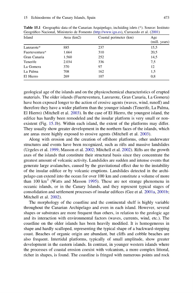
Table 15.1 Geographic data of the Canarian Arquipelago, incluiding islets (*). Source: Instituto
Geográfico Nacional, Ministerio de Fomento (http://www.ign.es), Carracedo et al. (2001)
Island
Area (km2)
Coastal perimeter (km)
Age
(mill. years)
Lanzarote*
885
237
15,5
Fuerteventura*
1.664
310
20,5
Gran Canaria
1.560
252
14,5
Tenerife
2.034
336
7,5
La Gomera
370
97
12
La Palma
708
162
1,5
El Hierro
269
107
0,8
15 Echinoderms of the Canary Islands, Spain
473
materials. The older islands (Fuerteventura, Lanzarote, Gran Canaria, La Gomera)
have been exposed longer to the action of erosive agents (waves, wind, runoff) and
therefore they have a wider platform than the younger islands (Tenerife, La Palma,
El Hierro) (Mitchell et al. 2003). In the case of El Hierro, the youngest island, the
edifice has hardly been remodeled and the insular platform is very small or nonexistent (Fig. 15.1b). Within each island, the extent of the platforms may differ.
They usually show greater development in the northern faces of the islands, which
are areas more highly exposed to erosive agents (Mitchell et al. 2003).
Along with erosion and the creation of offshore platforms, other underwater
structures and events have been recognized, such as rifts and massive landslides
(Urgeles et al. 1999; Masson et al. 2002; Mitchell et al. 2002). Rifts are the growth
axes of the islands that constitute their structural basis since they concentrate the
greatest amount of volcanic activity. Landslides are sudden and intense events that
generate large avalanches, caused by the gravitational effect due to the instability
of the insular edifice or by volcanic eruptions. Landslides detected in the archipelago can extend into the ocean for over 100 km and constitute a volume of more
than 100 km
3 (Watts and Masson 1995). These are not strange phenomena in
oceanic islands, or in the Canary Islands, and they represent typical stages of
consolidation and settlement processes of insular edifices (Gee et al. 2001a, 2001b;
Mitchell et al. 2002).
The morphology of the coastline and the continental shelf is highly variable
throughout the Canarian Archipelago and even in each island. However, several
shapes or substrates are more frequent than others, in relation to the geologic age
and its interaction with environmental factors (waves, currents, wind, etc.). The
coastline on the older islands has been heavily modified. It is homogeneous in
shape and hardly scalloped, representing the typical shape of a backward-stepping
coast. Beaches of organic origin are abundant, but cliffs and cobble beaches are
also frequent. Intertidal platforms, typically of small amplitude, show greater
development in the eastern islands. In contrast, in younger western islands where
the processes of coastal erosion coexist with volcanism, a more complex littoral,
richer in shapes, is found. The coastline is fringed with numerous points and rock
Table 15.1 Geographic data of the Canarian Arquipelago, incluiding islets (*). Source: Instituto
Geográfico Nacional, Ministerio de Fomento (http://www.ign.es), Carracedo et al. (2001)
Island
Area (km2)
Coastal perimeter (km)
Age
(mill. years)
Lanzarote*
885
237
15,5
Fuerteventura*
1.664
310
20,5
Gran Canaria
1.560
252
14,5
Tenerife
2.034
336
7,5
La Gomera
370
97
12
La Palma
708
162
1,5
El Hierro
269
107
0,8
15 Echinoderms of the Canary Islands, Spain
473