

Puerto Rico. The western shelf is broad and shallow, especially in the southwestern portion. Off the western edge of the shelf in the Mona Passage is Isla de
Mona (18°04
0 N–67°52
0 W), located 68 km west from the main island with an area
of 55 km
2 (Frank et al. 1998). The Mona Passage, which is about 120 km wide,
separates Puerto Rico from Hispaniola. The northern coastline is characterized by
a very narrow shelf with high energy and sandy beaches. There are other smaller
islets surrounding Puerto Rico: Monito and Desecheo on the western side, and
Culebrita and Palomino on the eastern side. The coastline of the main island is
580 km. However, if we add the adjacent islands of Vieques and Culebra, the total
shoreline is around 700 km.
14.1.1 Coastal Morphology
Sediment discharge from rivers is greater along the northern and western coasts,
than the eastern and southern coasts. This is due to the higher annual precipitation
levels in the northern and western parts of the island. Abundant sand dunes
characterize the northern and northwestern coast. Parts of these are submerged
while others have fossilized and formed rocky outcrops and beaches (García-Sais
et al. 2005). The eastern coast has sandy deposits with scattered rock formations.
Submarine canyons (Morelock et al. 1977) and mangrove islets characterize the
southern coast. In Culebra, mangroves grow along the southern while sand beaches
dominate the northern side. However, Vieques has an opposite pattern. This is the
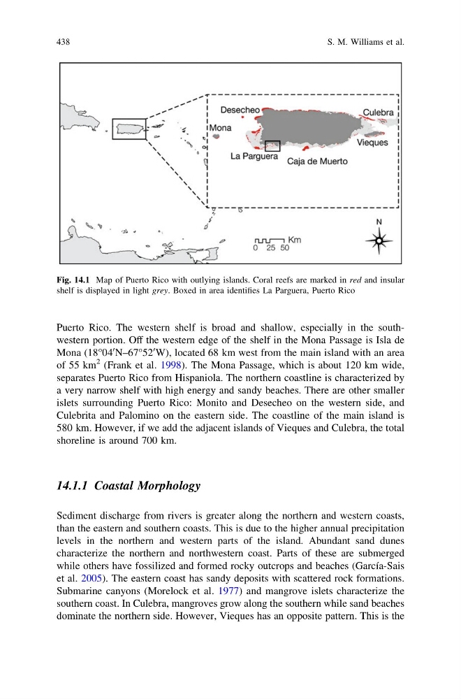
Fig. 14.1 Map of Puerto Rico with outlying islands. Coral reefs are marked in red and insular
shelf is displayed in light grey. Boxed in area identifies La Parguera, Puerto Rico
438
S. M. Williams et al.
Mona (18°04
0 N–67°52
0 W), located 68 km west from the main island with an area
of 55 km
2 (Frank et al. 1998). The Mona Passage, which is about 120 km wide,
separates Puerto Rico from Hispaniola. The northern coastline is characterized by
a very narrow shelf with high energy and sandy beaches. There are other smaller
islets surrounding Puerto Rico: Monito and Desecheo on the western side, and
Culebrita and Palomino on the eastern side. The coastline of the main island is
580 km. However, if we add the adjacent islands of Vieques and Culebra, the total
shoreline is around 700 km.
14.1.1 Coastal Morphology
Sediment discharge from rivers is greater along the northern and western coasts,
than the eastern and southern coasts. This is due to the higher annual precipitation
levels in the northern and western parts of the island. Abundant sand dunes
characterize the northern and northwestern coast. Parts of these are submerged
while others have fossilized and formed rocky outcrops and beaches (García-Sais
et al. 2005). The eastern coast has sandy deposits with scattered rock formations.
Submarine canyons (Morelock et al. 1977) and mangrove islets characterize the
southern coast. In Culebra, mangroves grow along the southern while sand beaches
dominate the northern side. However, Vieques has an opposite pattern. This is the
Fig. 14.1 Map of Puerto Rico with outlying islands. Coral reefs are marked in red and insular
shelf is displayed in light grey. Boxed in area identifies La Parguera, Puerto Rico
438
S. M. Williams et al.