

which continues with slight changes far beyond a depth of 600 m. These deep
mark the geographic limits of the Cuban Archipelago (Claro 2007).
The salinity and nutrient values of the Cuban platform water show comparatively wide seasonal and spatial variation since there is relative isolation of these
oceanic waters, the mean depth is small, and there is a high level of river damming. During the rainy season salinity may drop to an average of 32 % in some
regions and under certain conditions even more. On the other hand, in other sites
of limited exchange with the ocean, salinity may reach more than 50 % during the
dry season (Lluis-Riera 1972, 1977, 1981a, b, 1983, 1984; Alcolado et al. 1998;
Claro 2007).
The water circulation over the Cuban platform seems to be determined mainly
by the wind, the tide, and the influence of sea currents of the adjacent open sea
(Emilsson and Tápanes 1971) whereas the currents system in the oceanic water
that surrounds the Cuban Archipelago is extraordinarily complex and variable
(Sukhovey et al. 1980; García-Díaz et al. 1991; Victoria et al. 1997; Gallegos et al.
1998).
The horizontal distribution of the primary production in the platform is affected
by the hydrologic regime which is highly influenced by the oceanic currents and
winds and by the input of inland water. Changes on any of these factors or other
factors linked to them (e. g. local variation on the biogenic elements content), may
produce local conditions of variable duration resulting in different environmental
conditions for phytoplankton (Claro 2007).
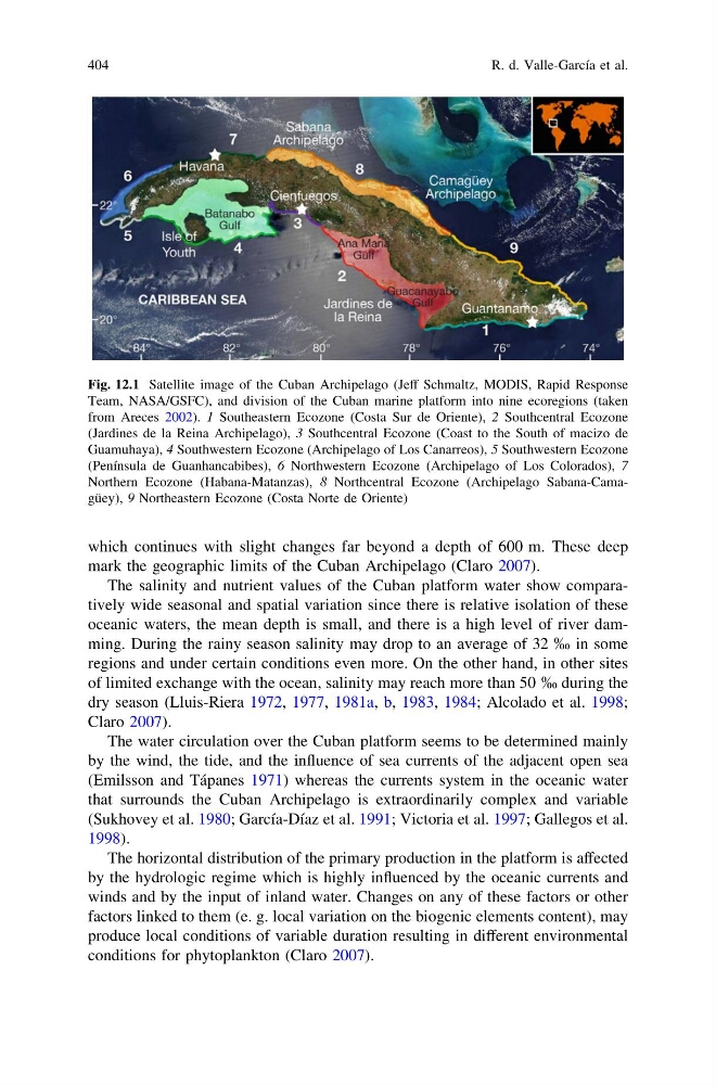
Fig. 12.1 Satellite image of the Cuban Archipelago (Jeff Schmaltz, MODIS, Rapid Response
Team, NASA/GSFC), and division of the Cuban marine platform into nine ecoregions (taken
from Areces 2002). 1 Southeastern Ecozone (Costa Sur de Oriente), 2 Southcentral Ecozone
(Jardines de la Reina Archipelago), 3 Southcentral Ecozone (Coast to the South of macizo de
Guamuhaya), 4 Southwestern Ecozone (Archipelago of Los Canarreos), 5 Southwestern Ecozone
(Península de Guanhancabibes), 6 Northwestern Ecozone (Archipelago of Los Colorados), 7
Northern Ecozone (Habana-Matanzas), 8 Northcentral Ecozone (Archipelago Sabana-Camagüey), 9 Northeastern Ecozone (Costa Norte de Oriente)
404
R. d. Valle-García et al.
mark the geographic limits of the Cuban Archipelago (Claro 2007).
The salinity and nutrient values of the Cuban platform water show comparatively wide seasonal and spatial variation since there is relative isolation of these
oceanic waters, the mean depth is small, and there is a high level of river damming. During the rainy season salinity may drop to an average of 32 % in some
regions and under certain conditions even more. On the other hand, in other sites
of limited exchange with the ocean, salinity may reach more than 50 % during the
dry season (Lluis-Riera 1972, 1977, 1981a, b, 1983, 1984; Alcolado et al. 1998;
Claro 2007).
The water circulation over the Cuban platform seems to be determined mainly
by the wind, the tide, and the influence of sea currents of the adjacent open sea
(Emilsson and Tápanes 1971) whereas the currents system in the oceanic water
that surrounds the Cuban Archipelago is extraordinarily complex and variable
(Sukhovey et al. 1980; García-Díaz et al. 1991; Victoria et al. 1997; Gallegos et al.
1998).
The horizontal distribution of the primary production in the platform is affected
by the hydrologic regime which is highly influenced by the oceanic currents and
winds and by the input of inland water. Changes on any of these factors or other
factors linked to them (e. g. local variation on the biogenic elements content), may
produce local conditions of variable duration resulting in different environmental
conditions for phytoplankton (Claro 2007).
Fig. 12.1 Satellite image of the Cuban Archipelago (Jeff Schmaltz, MODIS, Rapid Response
Team, NASA/GSFC), and division of the Cuban marine platform into nine ecoregions (taken
from Areces 2002). 1 Southeastern Ecozone (Costa Sur de Oriente), 2 Southcentral Ecozone
(Jardines de la Reina Archipelago), 3 Southcentral Ecozone (Coast to the South of macizo de
Guamuhaya), 4 Southwestern Ecozone (Archipelago of Los Canarreos), 5 Southwestern Ecozone
(Península de Guanhancabibes), 6 Northwestern Ecozone (Archipelago of Los Colorados), 7
Northern Ecozone (Habana-Matanzas), 8 Northcentral Ecozone (Archipelago Sabana-Camagüey), 9 Northeastern Ecozone (Costa Norte de Oriente)
404
R. d. Valle-García et al.