

52
The Suez Canal
N
calm
11111111111
weak
~
moderate ~~
s
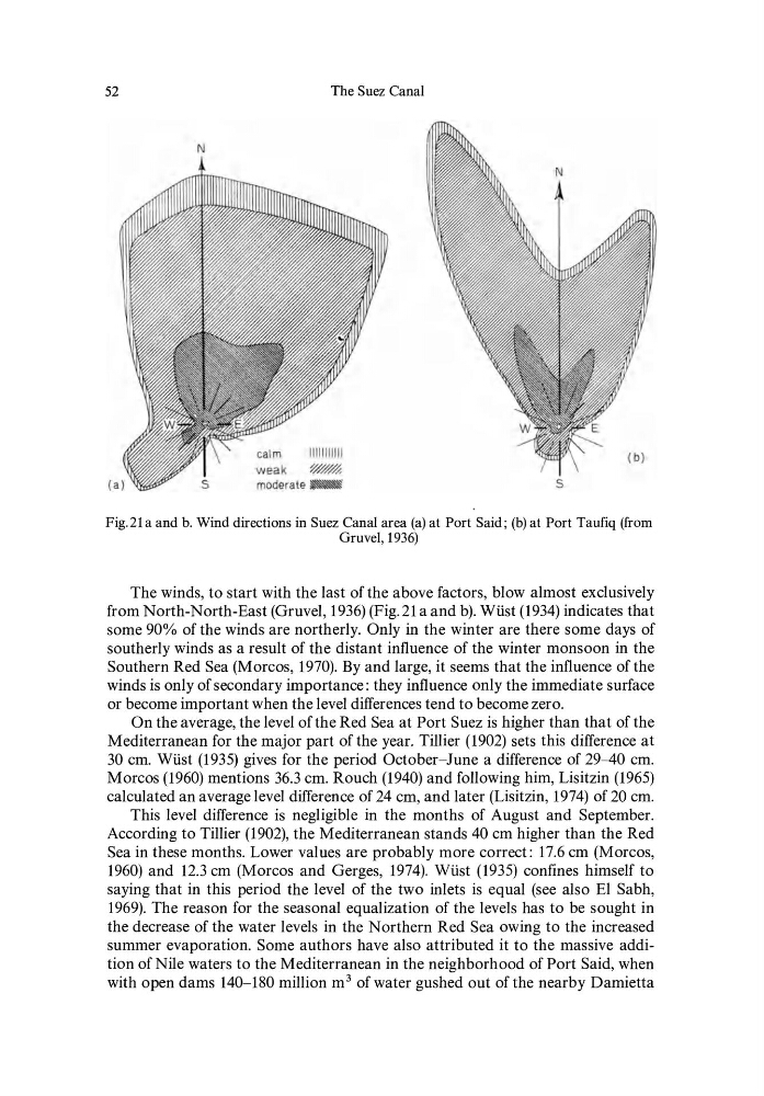
Fig.21 a and b. Wind directions in Suez Canal area (a) at Port Said; (b) at Port Taufiq (from
Gruvel,1936)
The winds, to start with the last of the above factors, blowalmost exclusively
from North-North-East(Gruvel, 1936)(Fig.21 a and b). Wüst(1934) indicates that
some 90% of the winds are northerly. Only in the winter are there some days of
southerly winds as a result of the distant influence of the winter monsoon in the
Southern Red Sea (Morcos, 1970). By and large, it seems that the influence of the
winds is only of secondary importance: they influence only the immediate surface
or become important when the level differences tend to become zero.
On the average, the level ofthe Red Sea at Port Suez is higher than that of the
Mediterranean for the major part of the year. Tillier (1902) sets this difference at
30 cm. Wüst (1935) gives for the period October-June a difference of 29-40 cm.
Morcos (1960) mentions 36.3 cm. Rouch (1940) and following hirn, Lisitzin (1965)
calculated an average level difference of 24 cm, and later (Lisitzin, 1974) of 20 cm.
This level difference is negligible in the months of August and September.
According to Tillier (1902), the Mediterranean stands 40 cm high er than the Red
Sea in these months. Lower values are probably more correct: 17.6 cm (Morcos,
1960) and 12.3 cm (Morcos and Gerges, 1974). Wüst (1935) confines hirnself to
saying that in this period the level of the two inlets is equal (see also EI Sabh,
1969). The reason for the seasonal equalization of the levels has to be sought in
the decrease of the water levels in the Northern Red Sea owing to the increased
summer evaporation. Some authors have also attributed it to the massive addition of Nile waters to the Mediterranean in the neighborhood of Port Said, when
with open dams 140-180 million m 3 ofwater gushed out ofthe nearby Damietta
The Suez Canal
N
calm
11111111111
weak
~
moderate ~~
s
Fig.21 a and b. Wind directions in Suez Canal area (a) at Port Said; (b) at Port Taufiq (from
Gruvel,1936)
The winds, to start with the last of the above factors, blowalmost exclusively
from North-North-East(Gruvel, 1936)(Fig.21 a and b). Wüst(1934) indicates that
some 90% of the winds are northerly. Only in the winter are there some days of
southerly winds as a result of the distant influence of the winter monsoon in the
Southern Red Sea (Morcos, 1970). By and large, it seems that the influence of the
winds is only of secondary importance: they influence only the immediate surface
or become important when the level differences tend to become zero.
On the average, the level ofthe Red Sea at Port Suez is higher than that of the
Mediterranean for the major part of the year. Tillier (1902) sets this difference at
30 cm. Wüst (1935) gives for the period October-June a difference of 29-40 cm.
Morcos (1960) mentions 36.3 cm. Rouch (1940) and following hirn, Lisitzin (1965)
calculated an average level difference of 24 cm, and later (Lisitzin, 1974) of 20 cm.
This level difference is negligible in the months of August and September.
According to Tillier (1902), the Mediterranean stands 40 cm high er than the Red
Sea in these months. Lower values are probably more correct: 17.6 cm (Morcos,
1960) and 12.3 cm (Morcos and Gerges, 1974). Wüst (1935) confines hirnself to
saying that in this period the level of the two inlets is equal (see also EI Sabh,
1969). The reason for the seasonal equalization of the levels has to be sought in
the decrease of the water levels in the Northern Red Sea owing to the increased
summer evaporation. Some authors have also attributed it to the massive addition of Nile waters to the Mediterranean in the neighborhood of Port Said, when
with open dams 140-180 million m 3 ofwater gushed out ofthe nearby Damietta