

108
C. Ronzani and A. Freytet
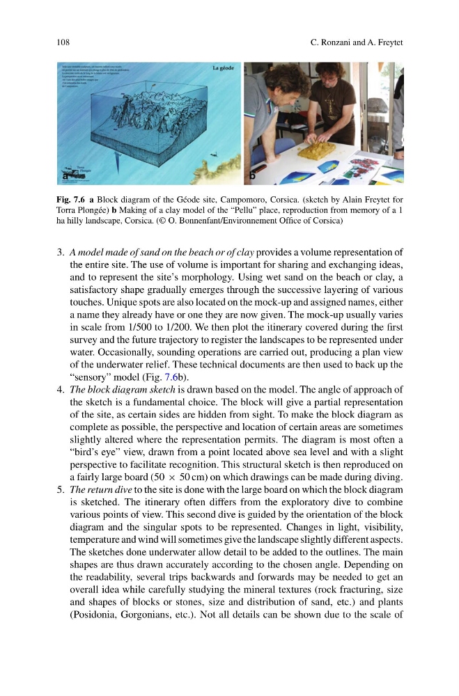
Fig. 7.6 a Block diagram of the Géode site, Campomoro, Corsica. (sketch by Alain Freytet for
Torra Plongée) b Making of a clay model of the “Pellu” place, reproduction from memory of a 1
ha hilly landscape, Corsica. (© O. Bonnenfant/Environnement Office of Corsica)
3. A model made of sand on the beach or of clay provides a volume representation of
the entire site. The use of volume is important for sharing and exchanging ideas,
and to represent the site’s morphology. Using wet sand on the beach or clay, a
satisfactory shape gradually emerges through the successive layering of various
touches. Unique spots are also located on the mock-up and assigned names, either
a name they already have or one they are now given. The mock-up usually varies
in scale from 1/500 to 1/200. We then plot the itinerary covered during the first
survey and the future trajectory to register the landscapes to be represented under
water. Occasionally, sounding operations are carried out, producing a plan view
of the underwater relief. These technical documents are then used to back up the
“sensory” model (Fig. 7.6b).
4. The block diagram sketch is drawn based on the model. The angle of approach of
the sketch is a fundamental choice. The block will give a partial representation
of the site, as certain sides are hidden from sight. To make the block diagram as
complete as possible, the perspective and location of certain areas are sometimes
slightly altered where the representation permits. The diagram is most often a
“bird’s eye” view, drawn from a point located above sea level and with a slight
perspective to facilitate recognition. This structural sketch is then reproduced on
a fairly large board (50 × 50 cm) on which drawings can be made during diving.
5. The return dive to the site is done with the large board on which the block diagram
is sketched. The itinerary often differs from the exploratory dive to combine
various points of view. This second dive is guided by the orientation of the block
diagram and the singular spots to be represented. Changes in light, visibility,
temperature and wind will sometimes give the landscape slightly different aspects.
The sketches done underwater allow detail to be added to the outlines. The main
shapes are thus drawn accurately according to the chosen angle. Depending on
the readability, several trips backwards and forwards may be needed to get an
overall idea while carefully studying the mineral textures (rock fracturing, size
and shapes of blocks or stones, size and distribution of sand, etc.) and plants
(Posidonia, Gorgonians, etc.). Not all details can be shown due to the scale of
C. Ronzani and A. Freytet
Fig. 7.6 a Block diagram of the Géode site, Campomoro, Corsica. (sketch by Alain Freytet for
Torra Plongée) b Making of a clay model of the “Pellu” place, reproduction from memory of a 1
ha hilly landscape, Corsica. (© O. Bonnenfant/Environnement Office of Corsica)
3. A model made of sand on the beach or of clay provides a volume representation of
the entire site. The use of volume is important for sharing and exchanging ideas,
and to represent the site’s morphology. Using wet sand on the beach or clay, a
satisfactory shape gradually emerges through the successive layering of various
touches. Unique spots are also located on the mock-up and assigned names, either
a name they already have or one they are now given. The mock-up usually varies
in scale from 1/500 to 1/200. We then plot the itinerary covered during the first
survey and the future trajectory to register the landscapes to be represented under
water. Occasionally, sounding operations are carried out, producing a plan view
of the underwater relief. These technical documents are then used to back up the
“sensory” model (Fig. 7.6b).
4. The block diagram sketch is drawn based on the model. The angle of approach of
the sketch is a fundamental choice. The block will give a partial representation
of the site, as certain sides are hidden from sight. To make the block diagram as
complete as possible, the perspective and location of certain areas are sometimes
slightly altered where the representation permits. The diagram is most often a
“bird’s eye” view, drawn from a point located above sea level and with a slight
perspective to facilitate recognition. This structural sketch is then reproduced on
a fairly large board (50 × 50 cm) on which drawings can be made during diving.
5. The return dive to the site is done with the large board on which the block diagram
is sketched. The itinerary often differs from the exploratory dive to combine
various points of view. This second dive is guided by the orientation of the block
diagram and the singular spots to be represented. Changes in light, visibility,
temperature and wind will sometimes give the landscape slightly different aspects.
The sketches done underwater allow detail to be added to the outlines. The main
shapes are thus drawn accurately according to the chosen angle. Depending on
the readability, several trips backwards and forwards may be needed to get an
overall idea while carefully studying the mineral textures (rock fracturing, size
and shapes of blocks or stones, size and distribution of sand, etc.) and plants
(Posidonia, Gorgonians, etc.). Not all details can be shown due to the scale of