

Chapter 15 Remote Sensing of Seagrasses
349
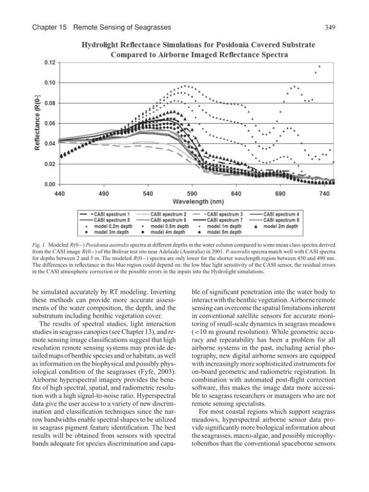
Fig. 1. Modeled R(0−) Posidonia australis spectra at different depths in the water column compared to some mean class spectra derived
from the CASI image R(0−) of the Bolivar test site near Adelaide (Australia) in 2001. P. australis spectra match well with CASI spectra
for depths between 2 and 5 m. The modeled R(0−) spectra are only lower for the shorter wavelength region between 450 and 490 nm.
The differences in reflectance in this blue region could depend on: the low blue light sensitivity of the CASI sensor, the residual errors
in the CASI atmospheric correction or the possible errors in the inputs into the Hydrolight simulations.
be simulated accurately by RT modeling. Inverting
these methods can provide more accurate assessments of the water composition, the depth, and the
substratum including benthic vegetation cover.
The results of spectral studies, light interaction
studies in seagrass canopies (see Chapter 13), and remote sensing image classifications suggest that high
resolution remote sensing systems may provide detailed maps of benthic species and/or habitats, as well
as information on the biophysical and possibly physiological condition of the seagrasses (Fyfe, 2003).
Airborne hyperspectral imagery provides the benefits of high spectral, spatial, and radiometric resolution with a high signal-to-noise ratio. Hyperspectral
data give the user access to a variety of new discrimination and classification techniques since the narrow bandwidths enable spectral shapes to be utilized
in seagrass pigment feature identification. The best
results will be obtained from sensors with spectral
bands adequate for species discrimination and capable of significant penetration into the water body to
interact with the benthic vegetation. Airborne remote
sensing can overcome the spatial limitations inherent
in conventional satellite sensors for accurate monitoring of small-scale dynamics in seagrass meadows
(<10 m ground resolution). While geometric accuracy and repeatability has been a problem for all
airborne systems in the past, including aerial photography, new digital airborne sensors are equipped
with increasingly more sophisticated instruments for
on-board geometric and radiometric registration. In
combination with automated post-flight correction
software, this makes the image data more accessible to seagrass researchers or managers who are not
remote sensing specialists.
For most coastal regions which support seagrass
meadows, hyperspectral airborne sensor data provide significantly more biological information about
the seagrasses, macro-algae, and possibly microphytobenthos than the conventional spaceborne sensors
349
Fig. 1. Modeled R(0−) Posidonia australis spectra at different depths in the water column compared to some mean class spectra derived
from the CASI image R(0−) of the Bolivar test site near Adelaide (Australia) in 2001. P. australis spectra match well with CASI spectra
for depths between 2 and 5 m. The modeled R(0−) spectra are only lower for the shorter wavelength region between 450 and 490 nm.
The differences in reflectance in this blue region could depend on: the low blue light sensitivity of the CASI sensor, the residual errors
in the CASI atmospheric correction or the possible errors in the inputs into the Hydrolight simulations.
be simulated accurately by RT modeling. Inverting
these methods can provide more accurate assessments of the water composition, the depth, and the
substratum including benthic vegetation cover.
The results of spectral studies, light interaction
studies in seagrass canopies (see Chapter 13), and remote sensing image classifications suggest that high
resolution remote sensing systems may provide detailed maps of benthic species and/or habitats, as well
as information on the biophysical and possibly physiological condition of the seagrasses (Fyfe, 2003).
Airborne hyperspectral imagery provides the benefits of high spectral, spatial, and radiometric resolution with a high signal-to-noise ratio. Hyperspectral
data give the user access to a variety of new discrimination and classification techniques since the narrow bandwidths enable spectral shapes to be utilized
in seagrass pigment feature identification. The best
results will be obtained from sensors with spectral
bands adequate for species discrimination and capable of significant penetration into the water body to
interact with the benthic vegetation. Airborne remote
sensing can overcome the spatial limitations inherent
in conventional satellite sensors for accurate monitoring of small-scale dynamics in seagrass meadows
(<10 m ground resolution). While geometric accuracy and repeatability has been a problem for all
airborne systems in the past, including aerial photography, new digital airborne sensors are equipped
with increasingly more sophisticated instruments for
on-board geometric and radiometric registration. In
combination with automated post-flight correction
software, this makes the image data more accessible to seagrass researchers or managers who are not
remote sensing specialists.
For most coastal regions which support seagrass
meadows, hyperspectral airborne sensor data provide significantly more biological information about
the seagrasses, macro-algae, and possibly microphytobenthos than the conventional spaceborne sensors