

266
2°30'N
42°N
2. RIA OF AROSA
3. RIA OF PONTEVEDRA
F.X. Niell et al.
1. CAPE PENAS
50° ~~~.----=~~
----~~~_==il_+_----=--'5°30 N CANTABRICSEA
43°30'N
4. RIA OF VIGO
River Lim"a
6. CANARY ISLANDS
17W
15 W
29 N
\) c7T~erif' jJ
\)
28 N
(J
"
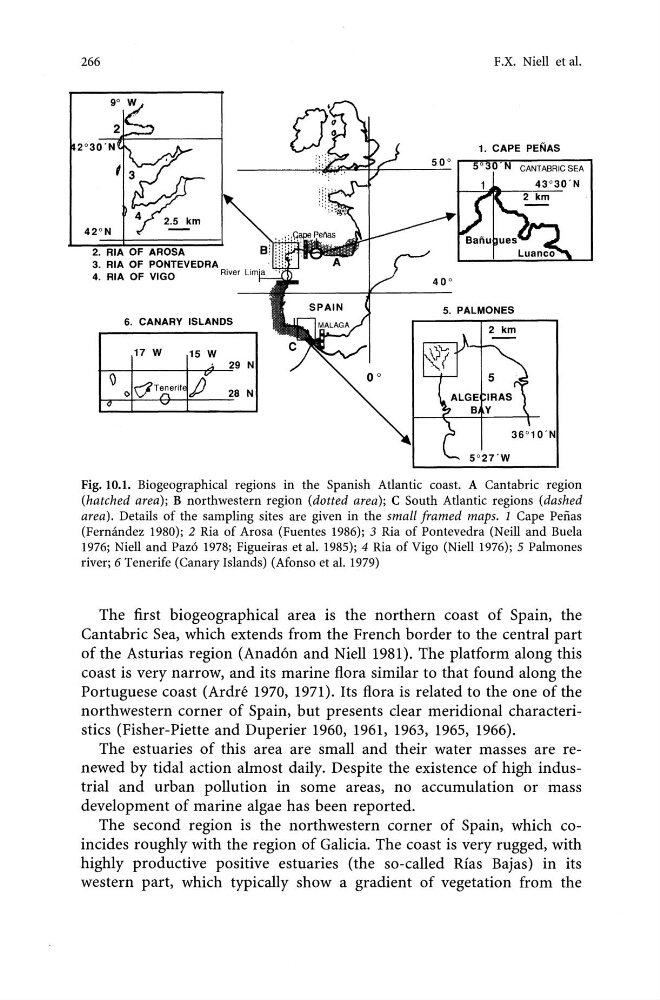
Fig. 10.1. Biogeographical regions in the Spanish Atlantic coast. A Cantabric region
(hatched area); B northwestern region (dotted area); C South Atlantic regions (dashed
area). Details of the sampling sites are given in the small framed maps. 1 Cape Pefias
(Fermmdez 1980); 2 Ria of Arosa (Fuentes 1986); 3 Ria of Pontevedra (Neill and Buela
1976; Niell and Paz6 1978; Figueiras et al. 1985); 4 Ria of Vigo (Niell 1976); 5 Palmones
river; 6 Tenerife (Canary Islands) (Afonso et al. 1979)
The first biogeographical area is the northern coast of Spain, the
Cantabric Sea, which extends from the French border to the central part
of the Asturias region (Anad6n and NielI1981). The platform along this
coast is very narrow, and its marine flora similar to that found along the
Portuguese coast (Ardre 1970, 1971). Its flora is related to the one of the
northwestern corner of Spain, but presents clear meridional characteristics (Fisher-Piette and Duperier 1960, 1961, 1963, 1965, 1966).
The estuaries of this area are small and their water masses are renewed by tidal action almost daily. Despite the existence of high industrial and urban pollution in some areas, no accumulation or mass
development of marine algae has been reported.
The second region is the northwestern corner of Spain, which coincides roughly with the region of Galicia. The coast is very rugged, with
highly productive positive estuaries (the so-called Rias Bajas) in its
western part, which typically show a gradient of vegetation from the
2°30'N
42°N
2. RIA OF AROSA
3. RIA OF PONTEVEDRA
F.X. Niell et al.
1. CAPE PENAS
50° ~~~.----=~~
----~~~_==il_+_----=--'5°30 N CANTABRICSEA
43°30'N
4. RIA OF VIGO
River Lim"a
6. CANARY ISLANDS
17W
15 W
29 N
\) c7T~erif' jJ
\)
28 N
(J
"
Fig. 10.1. Biogeographical regions in the Spanish Atlantic coast. A Cantabric region
(hatched area); B northwestern region (dotted area); C South Atlantic regions (dashed
area). Details of the sampling sites are given in the small framed maps. 1 Cape Pefias
(Fermmdez 1980); 2 Ria of Arosa (Fuentes 1986); 3 Ria of Pontevedra (Neill and Buela
1976; Niell and Paz6 1978; Figueiras et al. 1985); 4 Ria of Vigo (Niell 1976); 5 Palmones
river; 6 Tenerife (Canary Islands) (Afonso et al. 1979)
The first biogeographical area is the northern coast of Spain, the
Cantabric Sea, which extends from the French border to the central part
of the Asturias region (Anad6n and NielI1981). The platform along this
coast is very narrow, and its marine flora similar to that found along the
Portuguese coast (Ardre 1970, 1971). Its flora is related to the one of the
northwestern corner of Spain, but presents clear meridional characteristics (Fisher-Piette and Duperier 1960, 1961, 1963, 1965, 1966).
The estuaries of this area are small and their water masses are renewed by tidal action almost daily. Despite the existence of high industrial and urban pollution in some areas, no accumulation or mass
development of marine algae has been reported.
The second region is the northwestern corner of Spain, which coincides roughly with the region of Galicia. The coast is very rugged, with
highly productive positive estuaries (the so-called Rias Bajas) in its
western part, which typically show a gradient of vegetation from the